

Festus
-
Posts
599 -
Joined
-
Last visited
Content Type
Profiles
Blogs
Forums
American Weather
Media Demo
Store
Gallery
Posts posted by Festus
-
-
Well there’s a WWA both north and south but zippo here. I know it won’t change what actually will happen but you’d giving folks a heads up on upcoming hazardous weather would be prudent. Isn’t that one of the NWS primary functions?
Maybe we can start a petition down this way to secede from CTP and join Mount Holly. At least they have their shit together. (Aside - can you imagine going door to door with such a petition? I’d venture 99% of folks would have absolutely no idea what you are talking about, lol.)Edit: WWA issued! All is well in the world once again.
-
13 minutes ago, canderson said:
48 in HBG. WIndows open.
Aye, 48 in February feels a heck of a lot warmer than 48 in October.
-
 2
2
-
-
Sure was nice to get outside today. Hit some golf balls in the backyard for the first time in awhile. Comical to watch the ball bounce 10' in the air after landing on the rock hard frozen ground. Lots 'o winter remaining but getting twitchy for spring.
-
1
-
-
2 minutes ago, canderson said:
His Twitter account shows him livid and dying in even individual model run. So he’s just another rando who likes weather.
And his "Weather Discussion" is a Facebook page so count me out.
-
Well, this is exciting...not.

-
 1
1
-
-
My official observation so far would be “not much”. Maybe an inch but tough to tell with the wind.
If we calculate Total Forum Storm Accumulation / Total Forum Storm Posts, I think this has to be one of the lowest ratios ever.
As Mag said, still a ways to go so here’s hoping.
-
2 minutes ago, Itstrainingtime said:
"Itstrainingtime"
- I am a HUGE steam train fan
- I do a lot of regulatory compliance and personal development training at work
- It's also a nod to "training" storms
I combined 3 passions that all had synergy in one name.
Dude, that's awesome! We had a selfie party with the 611 this past season. Holy shit, was that thing cool! Anyway, back to weather.
-
1 minute ago, Itstrainingtime said:
Some areas went from 40" to 12" in 6 hours in the hours leading up to kickoff.
Most in our thread are to get .01" of QPF.
And now to go completely off topic, you used to be maytownpawx. Did you lose a bet or something? Sorry I'm new here and don't know the story.
-
 1
1
-
-
3 minutes ago, Itstrainingtime said:
Get ready for a weenie implosion in thread to our NE - the latest Euro is coming in significantly east of prior runs...
itsrainingtime +1. Just scrolled the last 2 pages. Dumpster fire now in progress. This hobby can be brutal.
-
1
-
-
2 - 5" now from WGAL is quite the upgrade from this morning's coating to 1". Savona seems to be slacking. We need Matt to get back in there and right the ship.
-
1
-
-
Yea, that had to be the fastest WWA ever reported. I was literally on CTP's site checking out the LWX version when Cashtown posted. The county hadn't even changed color yet! But even 1-3" tonight combined with temps in the teens with winds gusting upper 30's tomorrow should make it interesting here.
And it has never actually stopped snowing here so far although what has fallen has melted. Temp 31. Must be a sun angle thing
 .
.
-
26 accidents showing on Lancaster County's live incident list
 .
.
-
2
-
-
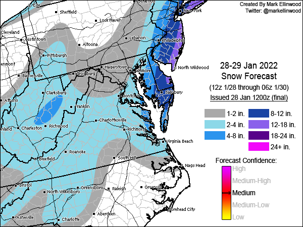
Updated map from Mark...
-
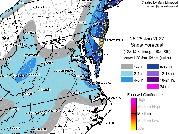
Lifted from MA. This guy is pretty good.
-
12Z NAM...

-
Bottomed at 7.2 this morning second to the 5.5 recorded on 1/16 and 4th single digit low so far this year.
-
1
-
-
Priceless AFD from Mount Holly. So you want to be an NWS forecaster...uh, well,
SHORT TERM /FRIDAY THROUGH SATURDAY NIGHT/... ...Major winter storm possible for much of the region Friday night and Saturday... It has been a live-or-die-by-every-model-timestep sort of night here at the office. And what the models give, they also take away, which basically describes the model variability we have seen the past couple of days with the potential winter storm for our region Friday night and Saturday. The 00z suite has made a notable consensus shift westward with the low tracking just off the coast, but the high volatility/variability remains. The 00z GFS is a far-east outlier solution and basically brings little snow to the CWA for the whole event. Meanwhile, the 00z NAM returned the snow to our area, in a large return of departure from the 18z NAM no-show (no-snow) event. The 00z CMC brings a blockbuster storm to the area, with widespread warning criteria south and east of the Fall Line; the 00z ECMWF is only somewhat drier than its 12z predecessor run. The 00z UKMET went sharply west, with meaningful QPF/snow for much of the area. The model volatility with this system has been something to behold. Such run-to-run spread is typical/expected for these types of events, given the highly complicated interdependent phenomena involved. However, simple analysis of the spread in the National Blend of Models is enlightening; the 04z NBM V4.0 (V4.1) 50th percentile storm total snow for the Philly area was around 1.5 (1) inch(es). The 75th percentile storm total snow was around 8 (10) inches, or roughly an order-of-magnitude difference between the median and the upper quartile. Bottom line here: the storm total snow forecast remains highly uncertain and subject to large changes in subsequent forecasts. Observation-wise, it will be critical to assess three regions/phenomena as the event unfolds: (1) the strength/depth, orientation, and speed of a northern-stream digging vort max through the Midwest on Friday morning, (2) the orientation and speed of a southern-stream vort max in the southern Plains around this same time, and (3) the low-level response to the phasing trough near/off the Southeast coast Friday night (e.g., the 850-mb heights and winds). The progressive solutions have a more compact and faster northern-stream vort max and a slower southern-stream vort max, which results in upper low development farther east (and generally too far east for our region to see substantive snow); the snowier solutions acquire phasing and neutral to negative tilt of the large- scale trough more quickly (and thus, farther west). Trends in the low-level response are obvious Friday night -- the NAM/CMC (aside from the errant 18z NAM simulation) are positioning the 850-mb low/trough farther southwest. The GFS is much noisier, exhibiting little trend. Notably, the 00z GEFS featured unusually low spread, which makes me wholly suspicious of the deterministic and ensemble output from its suite. With the model camps making the GFS more and more of an outlier, tonight`s forecast is generally a non-GFS consensus blend. This preserves a considerable amount of continuity to fields of importance such as PoPs, QPF, and snow amounts. The main changes were to sharpen the gradient of snow totals near/northwest of the I- 95 corridor, with 1-3 inch totals northwest of the Fall Line, 3-6 inch totals in the urban corridor and immediately adjacent areas, and 6-12 inch totals roughly from Easton, MD, to New Brunswick, NJ. Again, there is enormous uncertainty with these forecast totals. If the more progressive solutions pan out, very little snow may occur in a large chunk of the area. If the slower/stronger solutions pan out, heavier totals would occur at least to the Fall Line. Continue to monitor the forecasts, as large changes may occur leading up to the event. Based on the forecast totals, we have issued a winter storm watch for all of Delmarva, far southeastern Pennsylvania, and most of central and southern New Jersey from 7 pm Friday to 7 pm Saturday. Will fine-tune the timing once warnings/advisories are issued, but this is the general time window of concern for our area.-
1
-
-
Looking at 50's next week so if anything would fall, it won't be here long.
-
06Z Euro gives low end warning around these parts so we'll go with that. And the beaches...zoinks! We rent a place in Lewes in August. Hope everything is melted by then.
-
Attempt #2

-
1 minute ago, anotherman said:
That’s 12ZPoof. Thanks. Too many windows open at once.
-
Here's this mornings Mount Holly AFD regarding the weekend storm. It's a shame we're stuck with CTP.
All eyes remain on the late week period with the potential for a strong coastal storm to affect portions of the Eastern Seaboard. In short, there has not been much change to the forecast philosophy nor the gridded forecast. Overnight guidance, minus the 0z EC, generally favored a further offshore and less impactful evolution from this storm versus yesterday`s 12z runs. But at this stage, it is difficult to say whether these runs are any more reliable than those of yesterday, which generally showed a higher impact event. The storm threat remains, and we will be continuing to monitor. In terms of the technicals, it is pretty remarkable the sensitivity that operational guidance is showing to what the placement of a shortwave trough moving out of western Canada will be come late Thursday. There are other factors in play, and it will be a complex evolution, but that shortwave is the big one. It will be somewhere over the Southwest US by Thursday evening, but how far west it is will determine whether that shortwave gets left behind, or whether it phases with additional energy downstream. Much of the 24.12z guidance was more aggressive in ejecting that shortwave faster and further east, resulting in an earlier phase and major winter weather impacts for the mid-Atlantic. But the trend in most of the 24.18z and 25.00z guidance was for that shortwave to hang back more, resulting in an incomplete phase or a phase too late for much impact. The 25.0z EC was an exception, and shows what could happen in a faster phase scenario. These sort of fluctuations are common at this lead time, and will likely continue today. I hesitate to speculate too much on which outcome is more likely. However, will reiterate that the pattern does have similarities to past events where models displayed a right of track bias in the 3-5 day range. So if nothing else am definitely not inclined to write it off based on some of the more eastward 0z runs. Think we will probably start to see model solutions stabilize and converge towards tonight or tomorrow as shortwave energy is better sampled. For now, more generic messaging remains prudent. -
On 1/23/2022 at 2:00 PM, Festus said:
As has been the case here recently, blue overhead on radar, slate gray sky ... and ... bupkis. DP is 16 so sure looks like bupkis will continue for quite a bit longer.
Same shit...different day. Except DP is 19 now. Too funny. Is anyone getting anything from this so far? What's moving through Pittsburg right now doesn't look too bad.
-
Bupkis has been replaced by light snow. Temp 33. Nice to look at but that's about it for now.
Central PA - Winter 2021/2022
in Upstate New York/Pennsylvania
Posted
I don't think CTP sucks per se, but when I look at the output of LWX, PHI and BGM, they all are superior in terms of discussion, explanations and timeliness. Now who is most accurate? Beats me and of course that's where the rubber hits the road for Joe Public. And as Atomic stated earlier, it's only us weenies would be having this type of discussion.