Festus
-
Posts
656 -
Joined
-
Last visited
Content Type
Profiles
Blogs
Forums
American Weather
Media Demo
Store
Gallery
Everything posted by Festus
-
Central PA Winter 2022/2023
Festus replied to Blizzard of 93's topic in Upstate New York/Pennsylvania
As I'm fond of noting, today is the earliest sunset around these parts. By the time we get to the solstice, sunset will be about 3.5 minutes later. The latest sunrise will not occur until January 4th. And to really be the life of the party, next Wednesday, the 14th, is as close solar noon (sun at daily zenith) and clock noon come to coinciding. The difference will only be a few seconds. During Daylight Savings Time, solar noon occurs around +/- 1:00 PM. So if we eliminate Standard Time, next Wednesday will be the last time the two will ever coincide. -
NYZ010-011-171630- /O.CON.KBUF.LE.W.0005.221118T0000Z-221120T1800Z/ Northern Erie-Genesee- Including the cities of Buffalo and Batavia 328 AM EST Thu Nov 17 2022 ...LAKE EFFECT SNOW WARNING REMAINS IN EFFECT FROM 7 PM THIS EVENING TO 1 PM EST SUNDAY... * WHAT...Heavy lake effect snow expected. Total snow accumulations of 2 to 4 feet in the most persistent lake snows. The heaviest snow is expected late this evening through Friday night when snowfall rates could exceed 3 inches per hour. Winds gusting as high as 35 mph with produce patchy blowing snow. Now I love a good blizzard but I'm afraid I'd have to pass on this one.
-
Radar looks feisty. Any first flake reports out there?
-
The place was absolutely packed. Tough to find parking but what a sight. So I had on a drag racing shirt and this older dude wanders up and starts chatting about racing. He had on jeans and a denim shirt with 611 on it. I'm thinking this guy is hard core. Next thing I know, he was in the drivers seat! What a thrill it must be to operate something like that. And to keep the post relevant, what an absolutely wonderful weather day. Was there for 3 hours and never needed the coat.
-
For anyone interested, the 611 steam locomotive is running at Strasburg today. I believe it is the second largest operational steam locomotive in the country. It is certainly a site to behold. And who knows, maybe a guest appearance by our resident train expert Itstrainingtime.
-
Didn’t see it posted but total lunar eclipse tomorrow morning. Starts at 3:02AM, peak at 5:59AM, done at 6:49AM. Viewing conditions look good.
-
Millersville October 4th record officially set for lowest max temperature. Ironically enough. October 5th of last year was the record highest min temperature for the date. https://www.atmos.millersville.edu/~wic/climo/monthly-extremes/october.pdf
-
High of 49 so far. That is one ugly record to break for October 4th.
-
Record low max temperature at Millersville for the 4th is 52. Might have a shot at it.
-
So I'm watching Cantore and Abrams basically in the eyewall doing live shots. The NHC is showing max sustained winds of 150 mph. There's no way any person (and most structures) could withstand 150. So where exactly does the 150 reference to? Flight level?
-
So my local WU site says 84/72 for an index of 94. My NWS site says 82/72 for an index of 87. Plugging both sets of numbers into the NWS calculator shows the WU index is way too high (should be 90). Any idea why that is the case?
-
Now that we are officially in the humidity soup for awhile, what's the highest dewpoints y'all have ever recorded? A Philadelphia site says their highest was 82 in 1995 while a site named Cumberland Valley Weather says their highest was 85 in 2016.
-
Saw a graphic on WHTM that the average low temperature for July in Harrisburg is the 3rd highest on record. A little surprised as that is usually indicative of high dewpoints and it has not seemed particularly oppressive. Or maybe I'm just getting used to it.
-
86/73 here. Watch seems a little ambitious. Upstream radar has zippo. Here's hoping though, lawn is looking a bit parched. Need to get above Harrisburg to even get to D-0 on the Drought Monitor though.
-
Thanks for asking. Cars were in the garage so all good there. Did a drive around today and lots more carnage to be seen. Road still closed near Roots Market with huge trees across the road. Just one of those deals where folks a few miles away were like "what storm?" while those of us in the in the core saw substantial damage. Power was out for 6 hours but back now. Don't think it was tornadic given the wide swath of damage but again, worst I've seen in the 22 years here.
-
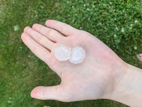
Neighbors on both sides lost trees. Hail pic was about 10 minutes afterward. Fortunately, the largest hail fell after the wind blast so no siding damage. Got a crap ton of clean up to do.
-
Got lambasted. Branches down, quarter size hail, house collapse nearby. Worst i have seen in the 22 years in our current house. Power out so will post hail pics later.
-
Another Tornado Warning north of Bel Air MD moving northeast. Might wander into southern Lancaster County. Edit: Just dropped, thank goodness.
-
Watch issued down this way. It is a rare day when a Tornado Warning is issued without a Watch in place prior to.
-
Todays high of 50 in Millersville would be the record low high temp if it were yesterday or tomorrow. But alas, today record low high temp is 46 so no soup there. But good lawd, it is butt ugly outside (I believe that is the official term). 3.29" storm total so far.
-
Millersville was close to a record low maximum temperature for the day. Record is 44 set in 2003, today reached 46. Gotta think there are a few record low maxes out there somewhere.
-
SPC has most of us in the Slight Risk zone for tomorrow: Farther north across the Mid-Atlantic, the severe threat should increase along and ahead of the cold front, which is expected to move through during the late afternoon and evening. Modest instability should develop ahead of the front amid filtered daytime heating and cooling mid-level temperatures. Low to mid-level flow across this region will remain strong. The resulting combination of modest buoyancy and robust vertical shear should result in the development of isolated strong to severe storms. Damaging winds are the primary threat, but low-level vertical shear is strong enough to support a tornado or two. Some marginally severe hail may also occur.
-
WWA was extended down this way but temp is 36. DP is 17 so some cooling is likely. Gonna be close.
-
Looking at all time monthly temperature record high/low for Harrisburg, the largest range is: 1. January - 95 degrees (high = 73, low = -22) 2. February - 92 degrees (high = 79, low = -13) 3. March - 88 degrees (high = 87, low = -1) If we throw in wind chill this AM, we're probably looking at 60 degrees this WEEK (low wind chill today = 10, high temp Thursday = 70). March indeed.
-
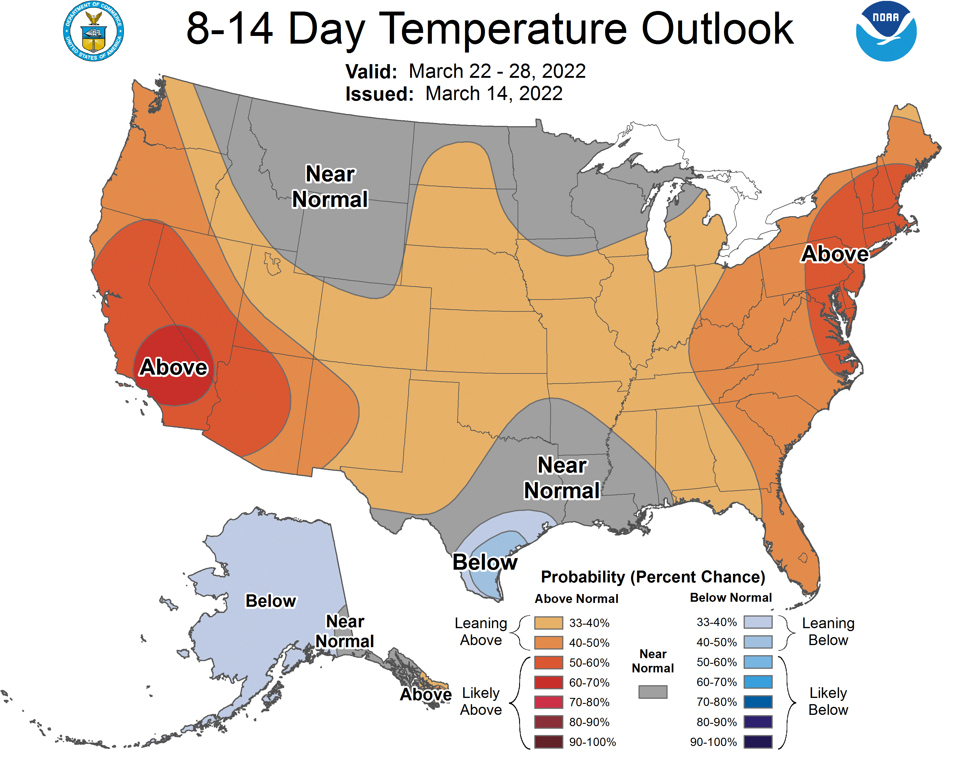
Latest CPC 8-14 day issued today has us a bit on the warm side.