

Festus
-
Posts
689 -
Joined
-
Last visited
Content Type
Profiles
Blogs
Forums
American Weather
Media Demo
Store
Gallery
Everything posted by Festus
-
Updated map from Mark...
-
Lifted from MA. This guy is pretty good.
-
12Z NAM...
-
Bottomed at 7.2 this morning second to the 5.5 recorded on 1/16 and 4th single digit low so far this year.
-
Priceless AFD from Mount Holly. So you want to be an NWS forecaster...uh, well, SHORT TERM /FRIDAY THROUGH SATURDAY NIGHT/... ...Major winter storm possible for much of the region Friday night and Saturday... It has been a live-or-die-by-every-model-timestep sort of night here at the office. And what the models give, they also take away, which basically describes the model variability we have seen the past couple of days with the potential winter storm for our region Friday night and Saturday. The 00z suite has made a notable consensus shift westward with the low tracking just off the coast, but the high volatility/variability remains. The 00z GFS is a far-east outlier solution and basically brings little snow to the CWA for the whole event. Meanwhile, the 00z NAM returned the snow to our area, in a large return of departure from the 18z NAM no-show (no-snow) event. The 00z CMC brings a blockbuster storm to the area, with widespread warning criteria south and east of the Fall Line; the 00z ECMWF is only somewhat drier than its 12z predecessor run. The 00z UKMET went sharply west, with meaningful QPF/snow for much of the area. The model volatility with this system has been something to behold. Such run-to-run spread is typical/expected for these types of events, given the highly complicated interdependent phenomena involved. However, simple analysis of the spread in the National Blend of Models is enlightening; the 04z NBM V4.0 (V4.1) 50th percentile storm total snow for the Philly area was around 1.5 (1) inch(es). The 75th percentile storm total snow was around 8 (10) inches, or roughly an order-of-magnitude difference between the median and the upper quartile. Bottom line here: the storm total snow forecast remains highly uncertain and subject to large changes in subsequent forecasts. Observation-wise, it will be critical to assess three regions/phenomena as the event unfolds: (1) the strength/depth, orientation, and speed of a northern-stream digging vort max through the Midwest on Friday morning, (2) the orientation and speed of a southern-stream vort max in the southern Plains around this same time, and (3) the low-level response to the phasing trough near/off the Southeast coast Friday night (e.g., the 850-mb heights and winds). The progressive solutions have a more compact and faster northern-stream vort max and a slower southern-stream vort max, which results in upper low development farther east (and generally too far east for our region to see substantive snow); the snowier solutions acquire phasing and neutral to negative tilt of the large- scale trough more quickly (and thus, farther west). Trends in the low-level response are obvious Friday night -- the NAM/CMC (aside from the errant 18z NAM simulation) are positioning the 850-mb low/trough farther southwest. The GFS is much noisier, exhibiting little trend. Notably, the 00z GEFS featured unusually low spread, which makes me wholly suspicious of the deterministic and ensemble output from its suite. With the model camps making the GFS more and more of an outlier, tonight`s forecast is generally a non-GFS consensus blend. This preserves a considerable amount of continuity to fields of importance such as PoPs, QPF, and snow amounts. The main changes were to sharpen the gradient of snow totals near/northwest of the I- 95 corridor, with 1-3 inch totals northwest of the Fall Line, 3-6 inch totals in the urban corridor and immediately adjacent areas, and 6-12 inch totals roughly from Easton, MD, to New Brunswick, NJ. Again, there is enormous uncertainty with these forecast totals. If the more progressive solutions pan out, very little snow may occur in a large chunk of the area. If the slower/stronger solutions pan out, heavier totals would occur at least to the Fall Line. Continue to monitor the forecasts, as large changes may occur leading up to the event. Based on the forecast totals, we have issued a winter storm watch for all of Delmarva, far southeastern Pennsylvania, and most of central and southern New Jersey from 7 pm Friday to 7 pm Saturday. Will fine-tune the timing once warnings/advisories are issued, but this is the general time window of concern for our area.
-
Looking at 50's next week so if anything would fall, it won't be here long.
-
06Z Euro gives low end warning around these parts so we'll go with that. And the beaches...zoinks! We rent a place in Lewes in August. Hope everything is melted by then.
-
Attempt #2
-
Poof. Thanks. Too many windows open at once.
-
Here's this mornings Mount Holly AFD regarding the weekend storm. It's a shame we're stuck with CTP. All eyes remain on the late week period with the potential for a strong coastal storm to affect portions of the Eastern Seaboard. In short, there has not been much change to the forecast philosophy nor the gridded forecast. Overnight guidance, minus the 0z EC, generally favored a further offshore and less impactful evolution from this storm versus yesterday`s 12z runs. But at this stage, it is difficult to say whether these runs are any more reliable than those of yesterday, which generally showed a higher impact event. The storm threat remains, and we will be continuing to monitor. In terms of the technicals, it is pretty remarkable the sensitivity that operational guidance is showing to what the placement of a shortwave trough moving out of western Canada will be come late Thursday. There are other factors in play, and it will be a complex evolution, but that shortwave is the big one. It will be somewhere over the Southwest US by Thursday evening, but how far west it is will determine whether that shortwave gets left behind, or whether it phases with additional energy downstream. Much of the 24.12z guidance was more aggressive in ejecting that shortwave faster and further east, resulting in an earlier phase and major winter weather impacts for the mid-Atlantic. But the trend in most of the 24.18z and 25.00z guidance was for that shortwave to hang back more, resulting in an incomplete phase or a phase too late for much impact. The 25.0z EC was an exception, and shows what could happen in a faster phase scenario. These sort of fluctuations are common at this lead time, and will likely continue today. I hesitate to speculate too much on which outcome is more likely. However, will reiterate that the pattern does have similarities to past events where models displayed a right of track bias in the 3-5 day range. So if nothing else am definitely not inclined to write it off based on some of the more eastward 0z runs. Think we will probably start to see model solutions stabilize and converge towards tonight or tomorrow as shortwave energy is better sampled. For now, more generic messaging remains prudent.
-
Same shit...different day. Except DP is 19 now. Too funny. Is anyone getting anything from this so far? What's moving through Pittsburg right now doesn't look too bad.
-
Bupkis has been replaced by light snow. Temp 33. Nice to look at but that's about it for now.
-
As has been the case here recently, blue overhead on radar, slate gray sky ... and ... bupkis. DP is 16 so sure looks like bupkis will continue for quite a bit longer.
-
If modeled snow actually happened…Reality…
-
Heating that 0 dewpoint air to 70 gives an RH of a whopping 6% Probably the thing I detest the most is the feeling of moisture getting wicked away from every nook and cranny. And for today's interesting fact, the global highest temperature in the past 24 hours was 115 in Australia. And the coldest was -66 in Russia. In fact, the top 15 coldest past 24 hour readings were all from Russia. No wonder they want to invade Ukraine. At least it's a little warmer there.
-
Climate Prediction Center long range forecast released yesterday shows way below average temperatures for the next 6 - 10 days, average for days 8 - 14 and a February torch for their 1 month outlook.
-
Yep. CTP southeast counties just added.
-
WWA issued for Berks and Chester counties down this way. ...WINTER WEATHER ADVISORY IN EFFECT FROM 3 AM TO 11 AM EST THURSDAY... * WHAT...Snow expected. Total snow accumulations of up to 2 inches, with local amounts up to 3 inches possible. * WHERE...Portions of northern New Jersey and eastern Pennsylvania.
-
All this long range eye candy is making me giddy. Since it takes a little over a month for air to traverse the globe, maybe the southern storm can come back around a little more tucked next month. Now we just need to lobby for a 768 GFS panel. And how does Accuweather manage those daily forecasts 3 months out anyway? Calling for a little rain on Easter Sunday (April 17th). Bummer. But at least the high will be 66.
-
Thackara just forecasted 2 - 3" for York and Lancaster and less N & W based on "updated guidance". Therefore, max will be a coating lol.
-
Well this sucks. No model showing anything. Anyone have access to the GRAPES model (Chinese)? That's gotta show a MECS to at least induce some panic.
-
Agree on early January and cold leading up to event so no surface temp or sun angle shenanigans. Would need some kind of bomb and stall or crawl scenario. At least 60 - 72 hour duration. Thundersnow in the evening for max effect (Cantore doing live feed and chasing the lightning would be icing on the cake). Also agree on not too much wind as power outages not cool. 30 - 40" for most. Want to get right on the edge but not risk structural collapse. Probably pressing that a bit at 3' though. So max snow but minimal damage to life and property.
-
As we debate the various X-ECS, riddle me this. If you could design the perfect winter storm for PA, how would it evolve, what features would be where and when, etc. Must use parameters that are in the realm of possibility.
-
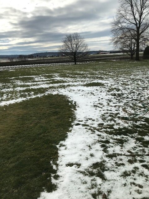
The literal "in my backyard" pic. Sure hope most of you folks are a little whiter. And what's up with Wednesday night? All of a sudden I have a Snow Likely in my grid forecast.
-
39/37 with grass showing through and some spots bare already. With DP above freezing, my "snow pack" is on life support. Meh, next.


