Festus
-
Posts
689 -
Joined
-
Last visited
Content Type
Profiles
Blogs
Forums
American Weather
Media Demo
Store
Gallery
Everything posted by Festus
-
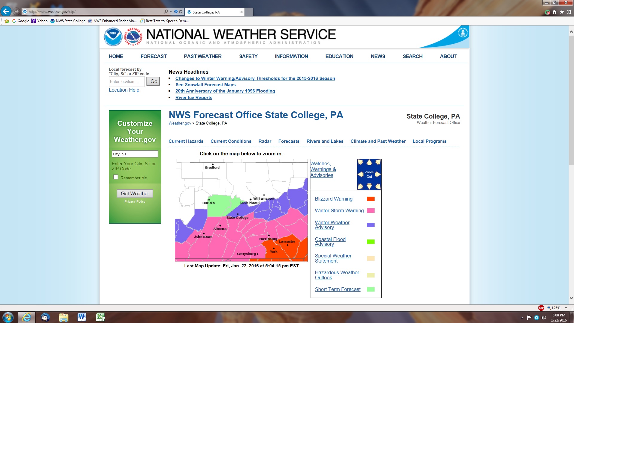
Cumulative GFS 200+ hr so far this season (not sure if Kuchera or 10:1 )
-
LWX downgraded the Maryland border counties to a WWA. 2-4". Not a great sign for any last minute northern creep.
-
Looking over CTP winter event history, the most recent significant ice storm around these parts was January 1, 2021. January 1st 2021 Ice Storm
-
Traffic accident extravaganza down this way this morning. 14 right now on the 911 Incident list. Be careful out there.
-
Forecast for Punxsutawney tomorrow is cloudy. Looks like you and Mitch are going pretty far out on a limb in using models versus a rodent.
-
Central PA Banter (Banter Less?) Thread
Festus replied to Itstrainingtime's topic in Upstate New York/Pennsylvania
In less than 24 hours, great to see POTUS has already found the root cause that being DEI. The bottom is calling asking if we're there yet. -
Wind Advisory hoisted for most of us. Gusting to 50 or maybe 60 at Canderson's wind tunnel.
-
With our epic cold snap now in the rearview mirror, the AVERAGE coldest day of the year for Harrisburg is January 29th. Interesting that the coldest day is pretty much in December for western USA and late January or even early February in eastern USA. Interactive map: Coldest day of the year across the United States | NOAA Climate.gov
-
Last 6 morning lows starting on the 20th: 2.1 -0.4 -7.1 -1.7 3.6 1.9
-
Looking at Millersville daily records, there's 2 days in 2014 and 1 day in 2018 with record lows just below zero. The Millersville low maximum for today is 12. So yes, at least in Millersville, this is the coldest outbreak since 1994.
-
-6 First time I can remember my geothermal system had to kick into auxiliary mode. And it's 5 above in International Falls at this hour. "Icebox of America" - not.
-
This is the 2016 Warning.
-
January 2016, saved for posterity...
-
5.6" total here. 2.3 low this morning. No chance at record cold this week as this is the same stretch of days as the epic 1994 event. Three straight days of -10 or greater lows and the only day in Millersville weather history where the high failed to reach above zero (-2). So when the youngsters go off on how cold it is, you have the "well, back in the day" at your disposal.
-
And not a flake yet a Lincoln Field. A little bumming about that.
-
Bailing here or as Eli Stolzfus would say, "it's makin daawn naw". Temp 28, visibility < 1/4 mile.
-
Considering how much of PA is covered by an Extreme Cold Watch, I can't say I recall that product being used before. Upon further review. as of October 1st: Wind Chill Watches will be renamed to an Extreme Cold Watch Wind Chill Warnings will be renamed to an Extreme Cold Warning Wind Chill Advisory will be renamed a Cold Weather Advisory
-
And then there's this - Project 2025 also said the National Weather Service should become a “performance-based organization” held accountable for achieving specific results, even if the head of the agency must “deviate from government rules” to achieve those results. Sounds like they'll be breaking out the retroactive Sharpie on the GFS maps.
-
Not to beat a dead horse but the phrase snow showers is defined as: "Snow falling at varying intensities for brief periods of time. Some accumulation is possible." At least in my neck of the woods, an 8 hour event depositing 4-8" is not brief and exceeds "some". But as mentioned, 4-8" of flurries, snow showers or blizzard is still 4-8". But alas, I remain amused by the terminology chosen is this case.
-
Agreed but Joe Q Public sees snow showers and thinks what we got yesterday. But then again, does Joe Q Public actually read NWS verbiage?
-
I mean this really is priceless - A slight chance of snow before 7am, then snow showers, mainly after 7am. High near 33. North wind 8 to 13 mph, with gusts as high as 20 mph. Chance of precipitation is 80%. New snow accumulation of 4 to 8 inches possible.
-
I see Trump's inauguration has been moved indoors. Guess he didn't want to pull a Harrison. At least there will be no crowd size disputes.
-
Soft commodities (wheat, corn, soybeans, etc.) are one place very weather dependent where markets are very liquid. Energy markets are another but they are pretty schizophrenic. I actually did pretty good at coffee futures using weather in Brazil like 15 years ago. It's gotten much more sophisticated nowadays but the principle stands.
-
Mood flakes here. Can still see the grass. Should have mowed lower on that last cut of the season. At this point, I'd say the Total Storm Posts / Total Storm Accumulation ratio is pretty high for this one. We need a bigger denominator!
-
Yes indeed! I'd plow my way along in my 1970 Chevy Impala. It would get stuck on like a 0.1% grade so the trick was to keep moving at any cost. Drivers nowadays have it too darn easy with front wheel drive, all wheel drive, traction control, ABS, blah, blah, blah. With that said, it's amazing how crappy some folks still manage to do when conditions are poor.