Festus
-
Posts
689 -
Joined
-
Last visited
Content Type
Profiles
Blogs
Forums
American Weather
Media Demo
Store
Gallery
Everything posted by Festus
-
Central PA Winter 25/26 Discussion and Obs
Festus replied to MAG5035's topic in Upstate New York/Pennsylvania
Watch hoisted for the whole forum. More than 48 hours in advance - might be a new record for CTP. Heavy mixed precipitation possible. Total snow and sleet accumulations up to two inches and ice accumulations between one tenth and three tenths of an inch possible. -
Central PA Winter 25/26 Discussion and Obs
Festus replied to MAG5035's topic in Upstate New York/Pennsylvania
Per Millersville archive, we received 3.5" on December 26, 1947. Geez, getting fringed even way back then. -
Central PA Winter 25/26 Discussion and Obs
Festus replied to MAG5035's topic in Upstate New York/Pennsylvania
5"+ for Lanco. Definitions, Thresholds, Criteria for Warnings, Watches and Advisories -
Central PA Fall Discussions and Obs
Festus replied to ChescoWx's topic in Upstate New York/Pennsylvania
As I'm fond of noting, today is the earliest sunset. It's another month or so for the latest sunrise. The discrepancy is the difference between true solar time and the chronological time we use. -
Central PA Fall Discussions and Obs
Festus replied to ChescoWx's topic in Upstate New York/Pennsylvania
Flurries at the moment. Temp 32.4. The only thing caved so far is expectations. -
Central PA Fall Discussions and Obs
Festus replied to ChescoWx's topic in Upstate New York/Pennsylvania
When was the last time it snowed in Central Pennsylvania on Thanksgiving? To find the last measurable snowfall, we have to go back over 35 years. According to the National Weather Service out of State College, the last measurable snow in the Harrisburg region occurred on Thanksgiving 1989 when 1.2 inches of snow fell. The maximum snowfall the Harrisburg area received on Thanksgiving in the last 50 years occurred in 1971. That was when 2.8 inches fell on Thanksgiving. That same year also set a record with the most snow on the ground during Thanksgiving, which was six inches. -
Central PA Fall Discussions and Obs
Festus replied to ChescoWx's topic in Upstate New York/Pennsylvania
The Chinook is absolutely correct. The write up is as follows: "A downslope chinook wind event pushed the temperature at the town of Loma from -54°F at 9 am on January 14, 1972, to 49°F by 8 am on January 15th. The 103°F (57.2°C) rise is the greatest change in temperature ever officially measured on earth within a 24-hour period." Can you imagine? According to AI , the Lancaster daily range record is 57 degrees set on December 23, 2022. -
Central PA Fall Discussions and Obs
Festus replied to ChescoWx's topic in Upstate New York/Pennsylvania
While a 92 degree difference is impressive, the national (and world) record for 24 hour temperature change IN ONE LOCATION is 103 degrees in Loma, Montana. Temp went from -54 to 49 on January 14/15 1972. -
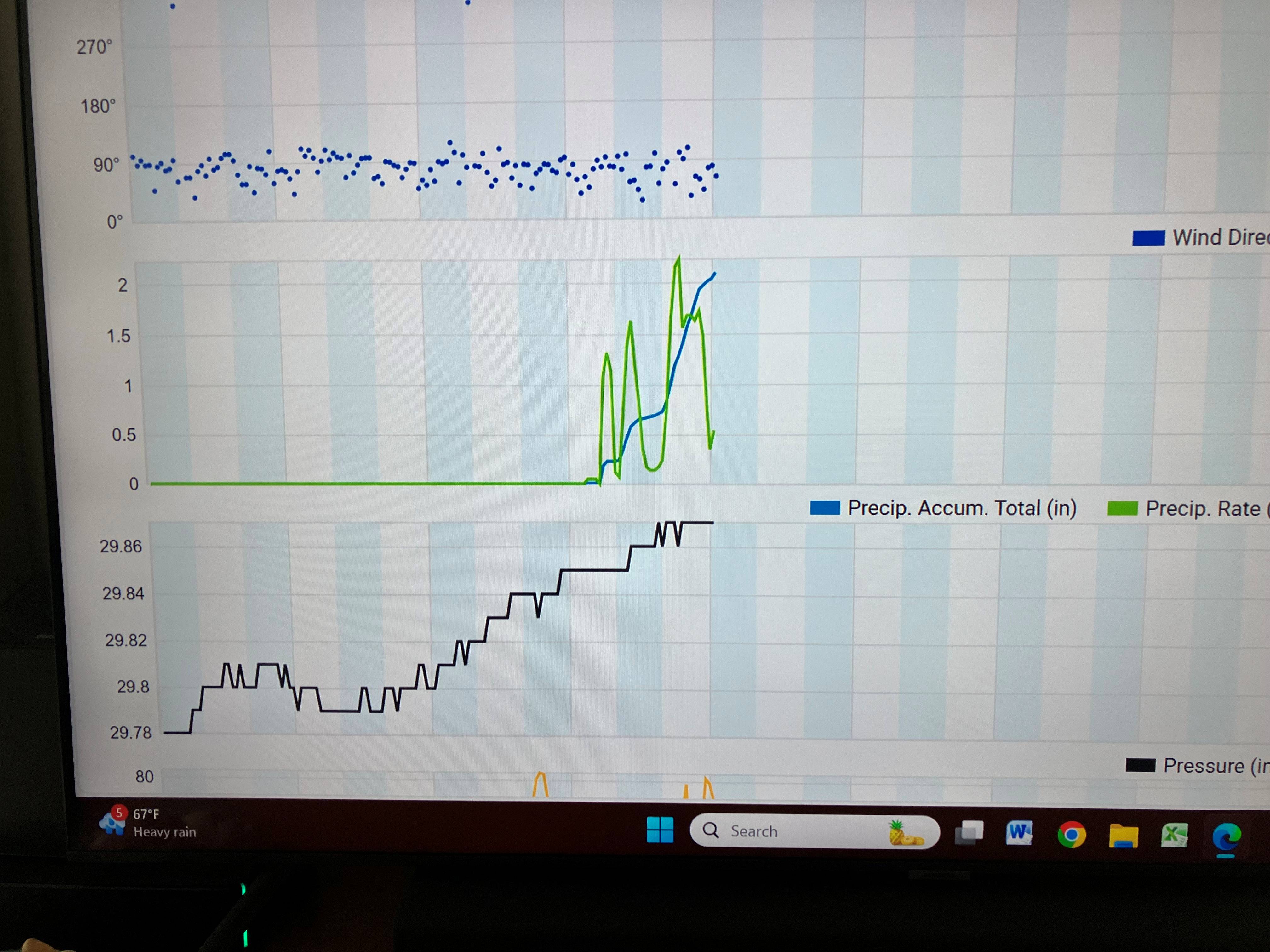
4.99" yesterday + 0.21" since midnight = 5.20" for East Petersburg. Holy f-bomb Batman.
-
3.87" so far today. Upstream (literally, lol) radar continues to fill in so maybe shot at 5". Absolutely unreal. So what's the mechanism for this mesoscale training over such a relatively small area?
-
From the station about 100 yards away...

-
Holy moly - Just under 2" in the last 1.5 hours and still raining hard. Local roads passable (at least where I am) but need to drive down the middle. Didn't see this coming.
-
Another Millersville record low max temperature set yesterday. High was 56 breaking the old record of 57. That's two record low max temps set 6 days apart from two different systems with data going back over 100 years. Remarkable.
-
Millersville high yesterday was 56 breaking the low max temperature record by 4 degrees.
-
Just missed the Millersville record low maximum temperature yesterday. Record was 56, was 57 just after midnight. Today's record low max is a relatively balmy 60. Should have no problem breaking that one, unfortunately.
-
Absolutely agree. We have an open southern exposure and I cannot recall such a sustained event. Next door neighbor's large willow was toppled a few hours ago. KLNS reported a 52 gust but I'm sure I've had stronger than that here.
-
Daylight Savings Time begins on the second Sunday in March and ends on the first Sunday in November. So the earliest it could ever change in March is the 8th.
-
it's mid February, so I do my usual check in here to catch up on the latest winter threats. I see a page of geography. Not a good sign.
-
Slow day so here's the list of most prolific regular posters in our forum. Apologies if I missed anyone. In thousands rounded to the nearest hundred: 1 Bubbler86 29.6 2 mitchnick 26.1 3 Canderson 23.3 4 Itstrainingtime 19.1 5 Sauss06 13.3 6 Voyager 12.0 7 Blizzard of 93 11.6 8 Paweather 11.4 9 Pasnownut 9.5 10 ChescoWx 8.9 11 MAG5035 5.9 12 WmsptWx 5.5 13 DDweatherman 5.2 14 Jns2183 4.7 15 mahantango#1 3.9 16 Mount Joy Snowman 3.8 17 Superstorm 3.8
-
Nothing compared to some of you but my upwind neighbor has a bunch of locust trees. I now have several thousand of those big ass seed pods covering my yard. Man I hate those trees.
-
Yeah, I agree with that but holy shit, just slow the eff down. It's not THAT hard.
-
I swear Lancaster County has the worst drivers on Earth. 32 accidents on the 911 list, 3 with entrapment. Wtf?
-
When it comes to forecasts, most locals I talk to or overhear usually cite output from WGAL or WHTM (and rarely, the NWS, sadly). I'm guessing most of our family, friends, coworkers, etc know we're weather weenies and look to us as "being in the know". So when you provide the latest to them, what's your method? Average the latest model runs in your head and customize a forecast? Weight output from the NWS a little heavier? A favorite source here or elsewhere? Don't touch the subject with a ten foot pole?
-
Didn't Accuweather have forums at one point? I seem to recall they were a train wreck but don't remember the specifics.
-
Micro flakes here but flakes nonetheless.