

jaxjagman
-
Posts
8,285 -
Joined
-
Last visited
Content Type
Profiles
Blogs
Forums
American Weather
Media Demo
Store
Gallery
Posts posted by jaxjagman
-
-
Tornado emergency
-
 1
1
-
-
1 minute ago, BYG Jacob said:
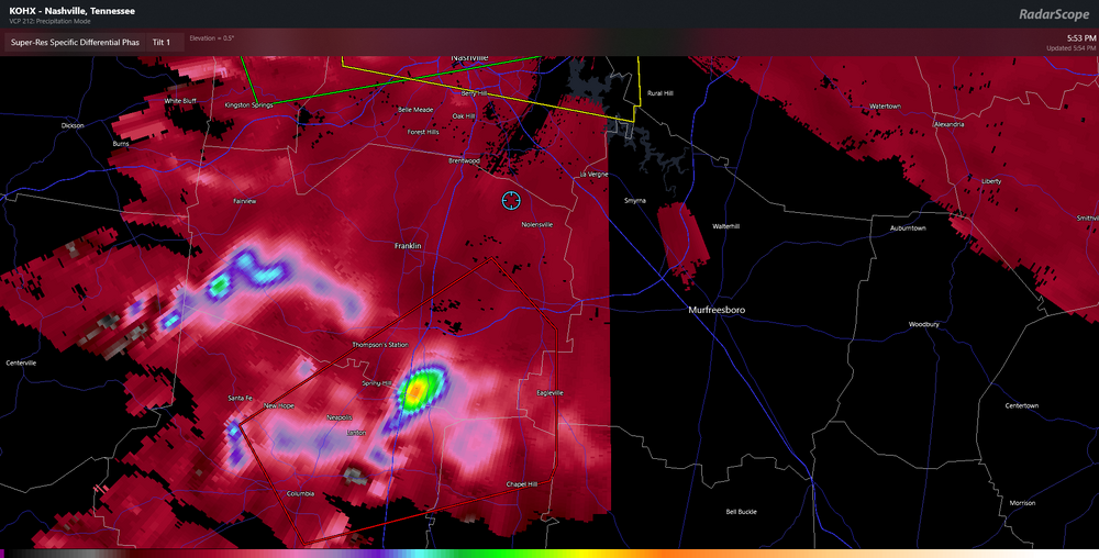
That Columbia tornado looks bad
Its PDS now
-
1
-
-
11 minutes ago, Matthew70 said:
We are lucky so far today. Brief touchdowns so far.
See what happens soon,we havent been touched today
-
1
-
-
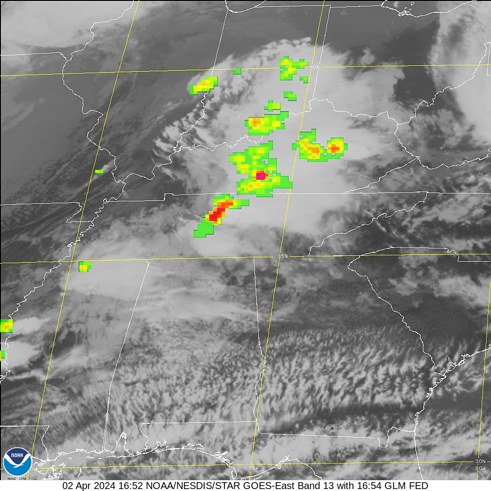
Holenwald better look out that cell looks violent
-
Possibly Clifton around there might be next
-
Cell around Perryville might go torwarn soon
-
HRRR has been showing a stronger cap compared to the RAP,dunno who is gonna be right
National Weather Service Nashville TN
914 AM CDT Wed May 8 2024

...New MESOSCALE UPDATE...

.MESOSCALE UPDATE...
Issued at 856 AM CDT Wed May 8 2024

Warm front has become stationary close to I-40. Showers with very
heavy rainfall and thunderstorms continue to move eastward along
and just north of the boundary. Very heavy rainfall continues to
feed the flood threat across our far north.

To the south, the southern half of the mid state will receive a
break with some capping now noted into the early afternoon.
However, SPC parameters indicate additional destabilization as the
day wears on. Primary push of pre frontal initial energy appears
to be mid to late afternoon. At that time...cape values of up to
4000 j/kg will be in place across our south with MLLR`s of 7C to 7
1/2C. Some clearing is already noted in our southwest....not
good. 0-1km Helicity values will be in the 100-200 M(2) S(-2)
range. Severe out break round 1 will likely occur across the
central and south as we move into the mid to late afternoon. All
forms of severe weather will be possible.

Activity now firing across central Mo. This will represent the
energy later in association with the primary frontal boundary.
This round 2 activity looks like sometime between 6 PM and
midnight for all of the mid state. Again, all forms of severe
weather will be possible.
-
Smith Co tornado yesterday was a confirmed EF-1
-
2
-
 1
1
-
-
National Weather Service Nashville TN
210 AM CDT Tue May 7 2024

...New SHORT TERM, LONG TERM...

.SHORT TERM...
(Today through Tonight)
Issued at 202 AM CDT Tue May 7 2024

Radar is clear at forecast time. Same goes for the satellite.
With small to almost zero dew point depressions, fog has already
started to develop in many areas across Middle TN. Right now, only
a couple of spots are showing anything dense, but this may change
over the next couple of hours. Winds at about 1kft are 20 kts off
the OHX VAD profiler and this may be enough to keep us from
getting widespread dense stuff, but an advisory may become
necessary in the next couple of hours.

Well, I`m glad I bumped PoPs from what the NBM gave me yesterday
morning. However, storms WAY overperformed yesterday afternoon from
what I was seeing in the models at this time yesterday morning. CAPE
was near 2000 J/Kg as expected, but even with meager shear, storms
were able to produce large hail, damaging wind and from the look of
it, possibly a couple tornadoes. That does not bode well for the
next couple of days because forecast soundings over the next 72
hours look much more severe than yesterday.

Let`s start with today. Remnants of yesterday`s High Risk area over
the Plains merged into a QLCS last night, which is now wreaking
havoc over western Missouri. This QLCS feature will continue pushing
eastward through the morning hours and while latest CAMs have it
falling apart upstream from us late this morning, the residual
outflows from this system may very well provide us with the lift I
thought we may be missing today. Forecast soundings are healthy.
2500+ CAPE values, lapse rates similar to yesterday and much better
shear values than I was seeing for yesterday`s storms. For these
reasons, while I think damaging wind gusts (60+ mph) and large hail
will be the main threats, any storms that develop will likely be
rotating, so while lower on the totem pole, I can`t rule out a
tornado threat. In addition, with the amount of rain we`ve received
over the last couple of days and PWs in the 90th percentile this
afternoon, localized flash flooding is also possible. Please don`t
sleep on the flash flood threat and heed any warnings that may be
issued. Ok. That`s just the afternoon. Almost across the board, CAMs
are showing additional development tonight as another wave passes
through the region. While we lose some of the heating of the day,
CAPE values only fall into the 1000-1500 J/Kg range. This means
we`ll hold onto plenty of instability during the overnight hours.
Deep layer shear holds steady around 40 kts and helicities are such
to sustain updrafts. This means we`ll hold an overnight severe
threat, as well, with any additional storms that develop. It also
means that we`re going to be dealing with overnight severe potential
two nights in a row.

&&

.LONG TERM...
(Wednesday through next Tuesday)
Issued at 202 AM CDT Tue May 7 2024

While today and tonight`s severe threat is healthy, that might make
Wednesday`s severe potential super human. In fact, with the forecast
soundings I`m seeing I am becoming a little worried. As tonight`s
storms wane towards daybreak, the boundary created by them is
actually being picked up in some of our models. This is unusual and
may serve as a quasi-warm front that is expected to slowly lift back
to the north during the late morning and early afternoon hours on
Wednesday. As it lifts, there is some signal of convection
developing along this boundary. With forecast soundings showing
3000+ CAPE south of the boundary, plenty of shear and mid-level
lapse rates closing in on 7.0 deg/km, there is some concern of
discrete supercell development Wednesday afternoon. Supercell
composites closing in on 10.0 and STP values nearing 2.0 suggest a
fairly decent chance of tornado development. In addition, lapse
rates only get worse through the afternoon. This means large hail
(1.5 inches or larger) is going to be possible. While the afternoon
potential for severe weather is more on the isolated to scattered
level, yet another round of much more widespread storms is still
expected Wednesday night. Again, this is an all-mode severe weather
threat overnight Wednesday into early Thursday morning, with
damaging wind gusts, large hail, tornadoes and flash flooding all
possible.

The next 48-60 hours is going to be VERY active across Middle TN.
This is not a time to fret, however. Take this morning and review
your safety plan for you and your family. Know where you need to go
for shelter if you go under a warning. Wherever that shelter may
be, have essential items in there waiting for you. Phone chargers,
NOAA Weather Radios, helmets for the kiddos, just to name a few.
If you need additional support for making a plan, please visit
ready.gov/plan to help you put one together. Don`t wait until you
go under a warning. Be prepared. Especially with overnight severe
threats for the next two nights. Don`t go to bed without having
your phone fully charged and the volume turned up so you can wake
up and get to shelter.

Once we get through early Thursday morning, I think the severe
threat is over. There is an outlier signal from the NAM that the
front may not get all the way through Middle TN on Thursday and we
could see additional storms Thursday night across our south, but
let`s deal with that once we get through the next two days. By
Friday, temperatures relax back into the 70s and while the GFS is
suggesting some showers and storms on Saturday, most models do not,
so hopefully we can remain dry for several days after Thursday
morning.
-
1
-
 1
1
-
-
On 5/4/2024 at 4:56 PM, Matthew70 said:
Looks like multi days of all modes of severe wx this week. SPC has pretty strong wording. Spreading into middle TN late Tuesday into Wednesday.
Flooding rains looks very likely.Best day of severe right now seems to be Tues/Wed like you said,low level shear picks up Tuesday into Wed,other wise looks more wind and possibly severe hail.But i agree flooding could be a issue with training cells.Pollen has been pretty brutal here,its good to get some rain
-
1
-
-
On 5/2/2024 at 2:08 PM, nrgjeff said:
I expect parts of the Mid-South and Midwest to join the SPC Day 4-8 day outlook in the next day or two; so, look Friday or Saturday.
It's wild how the Great Plains could get whacked Monday, then get quiet. Then the trough slows down to gradually work through the Mid-South and Midwest (IL/IN/OH). Each day a wave slides around the base and ejects out. LLJ responds. Kentucky could get clipped next week.
Feels late in the season but it's not. Early May is still the heart of the season. Most of those states peak in May too.
Like freaking bombs...lol
-
2
-
-
Geeze !!
-
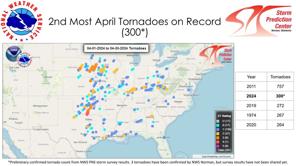
Pretty active April,not much of anything in Tn
-
2
-
-
.SHORT TERM...
(Today through Tuesday)
Issued at 220 AM CDT Mon Apr 15 2024

Record highs are possible today as a strong ridge axis extending
from the Gulf of Mexico to the Upper Midwest builds eastward
across Tennessee. Highs yesterday climbed well above all guidance
values. The warming and enhanced wind gusts occurred as full
sunshine and dry air allowed very deep vertical mixing. Mixing may
not be quite as strong today, but we should still meet or exceed
yesterday`s highs. Wind speeds will be much lower today as the
high pressure builds across the area.

BNA climate data for today:
Normal high 73
Forecast 87
Record 87 from 1936

BNA climate data for Tuesday:
Normal high 73
Forecast 87
Record 88 from 1955

The warm conditions will continue tonight and Tuesday under the
strong ridge. Winds will pick up again Tuesday, with gusts as high
as 30 mph in the afternoon.
-
Maybe starting to recycle
-
-
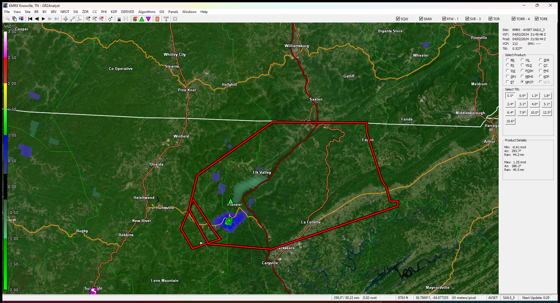
Moving fast,looks like maybe south of Pioneer
-
see it wiped out a funeral home of all places
-
2
-
-
26 minutes ago, Holston_River_Rambler said:
Tornado warning north of me near Sunbright.
Says thats a confirmed tornado
-
1
-
-
Cells seem to be moving pretty quick now than earlier
-
Some decent rotation starting to show west of Fairview
-
3 minutes ago, Runman292 said:
Here's a funny gaffe. 10 news was posting about the Tornado watch that was issued for Southeastern KY, but their graphic says tornado warning.
Big tornado

-
 1
1
-
-
Nice thunderstorm,power got knocked off for a few min,wish it was at night,some intense lightning
-
2
-
-
3 minutes ago, Runman292 said:
Is it just me, or does it seem like this system is going to arrive in East TN faster than the 6 PM time frame that the local Mets are saying?
RAP and HRR shows more that will develop later on so we'll see
-
1
-
1
-


Tn Valley Severe Weather
in Tennessee Valley
Posted
Confirmed deaths in Columbia