

dendrite
-
Posts
63,285 -
Joined
Content Type
Profiles
Blogs
Forums
American Weather
Media Demo
Store
Gallery
Posts posted by dendrite
-
-
Euro caves quite a bit.
-
This thing is still east of the Delmarva and it's getting written off. All I'm saying. It's heading due north right now. Not northeast.
I'm only posting what the GFS is showing. I'm not saying I buy it or the RGEM. I can't imagine the Euro busting that badly in 1 run at T minus 0. I'm enjoying the model mayhem...it keeps met jobs.
-
b**ch and whine whether its cold and dry or a blizzard. I think I need a break. It's no fun
Easy to say when you're in one of the perfect spots for this. Many on here were under 24-36" and are in danger of getting the rug pulled out under them. lol
-
Hey kids...so you wanna be a meteorologist?
Still a good hit for ENE, but my condolences to WNE.
-
I think the euro is going to cave harder than we think tonight.
-
GFS going pretty far east from 18z.
-
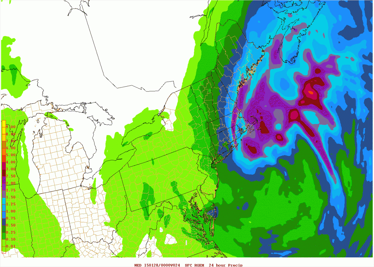
Does Kev get his RGEM wish? lol
Ray FTW

-
You have a map for the rest of the region?
-
TTN went from >2.00" QPF to 0.25" on the 4km NAM. Ouch.
-
NYC already has up to 6" from earlier today, so another 12" would bring some to 18" by itself, and that's doable with 12-1 ratios and 1" liquid. Obviously anywhere east of there is still in for a crushing regardless.
Well aware. NYC was in that meso band for awhile. I'm talking more south of the city into E NJ.
-
I mean it's a region wide blizzard. NYC is on the fence, LI gets crushed, CT, MA, RI, Boston, PVD, Portsmouth. The SW edge is a toss up...but everywhere else it's stay the course...feet of snow.
Horrible run-to-run consistency. Every run crushes CT/S NH/MA/RI, but those on the edge are getting flip flopped between 2ft and 6-10".
-
lol...the model is so horrible. Nice hit here, but does it even matter?
-
Well when I do it I pretty much just look at the early hours. Anything past 6hr...meh.There is literally no point yet. RPM looks clueless. Honestly, euro looks pretty good so far with its 12z run.
-
epicMake that .6F, now 30.3F
Obs thread though James.
-
22z HRRR comes west a bit. Analyzing these hourly models blows.
-
euro had about 0.15" QPF in the 18-00z period in the NYC area. Precip totals since 18z so far...Definitely beginning to see the pivot taking place, radar is also filling in. I am still surprised by the fact that the returns down there are that far east of the NJ shoreline at this stage. I anticipated the back edge of the broken precip would have started essentially right on the beaches per the Euro. We're 40 minutes from verification - again rough glance but it all looks a little east to me and not fast enough up near the Cape with this first band.
LGA 0.20"
EWR 0.12"
JFK 0.11"
Of course some of that is a meso weenie band.
-
The meltdowns would be epic. I wouldn't cheer that on, but I would find a way to take sick pleasure out of that.Can't imagine this verifying. From 5pm onwards

-
22z RAP not looking as favorable for NYC as 21z did.
-
How much since 1pm when the GFS initialized?GFS was already wrong for NYC. NYC reporting 4.5" as of 5:00
-
I was thinking a tick SE of the ecens.I think the RGEM is too far east also...but I think the Euro might be too far west by a little...I am still envisioning some sort of compromise.
I think Kev may have gottenmore from the NAM...lol
-
I can't buy the 12z euro op/ens losing that badly to the 18z RGEM. I've tossed the RGEM.
-
Wow and Eek are the tech guys. I just pass along what I can.Thanks Dendrite
And thanks to you and Wow and Eell keeping this running
-
EPS mean for the weens. I'm pulling this in a few mins.
-
Nice to see the 4k NAM cave towards it's lower res brother. Night and day from 12z.
Forecast/storm discussions and part II Manitoba Mauler
in New England
Posted
Nice hit for E NH, E MA, and ME though.