dendrite
-
Posts
73,493 -
Joined
Content Type
Profiles
Blogs
Forums
American Weather
Media Demo
Store
Gallery
Everything posted by dendrite
-
GFS 2m fantasy like when it gives us 113° in July
-

January 2026 regional war/obs/disco thread
dendrite replied to Baroclinic Zone's topic in New England
24” for Wilmington and 11” for Methuen when all is said and done? -
January 2026 regional war/obs/disco thread
dendrite replied to Baroclinic Zone's topic in New England
Way too early to be worrying about coastal front exhaust. -
January 2026 regional war/obs/disco thread
dendrite replied to Baroclinic Zone's topic in New England
At least his 9.7 beat Scott’s 9.4 -
January 2026 regional war/obs/disco thread
dendrite replied to Baroclinic Zone's topic in New England
Ray is already shook from a 1/2” less on a d6 prog -
January 2026 regional war/obs/disco thread
dendrite replied to Baroclinic Zone's topic in New England
I could make a lot of money from metfan with this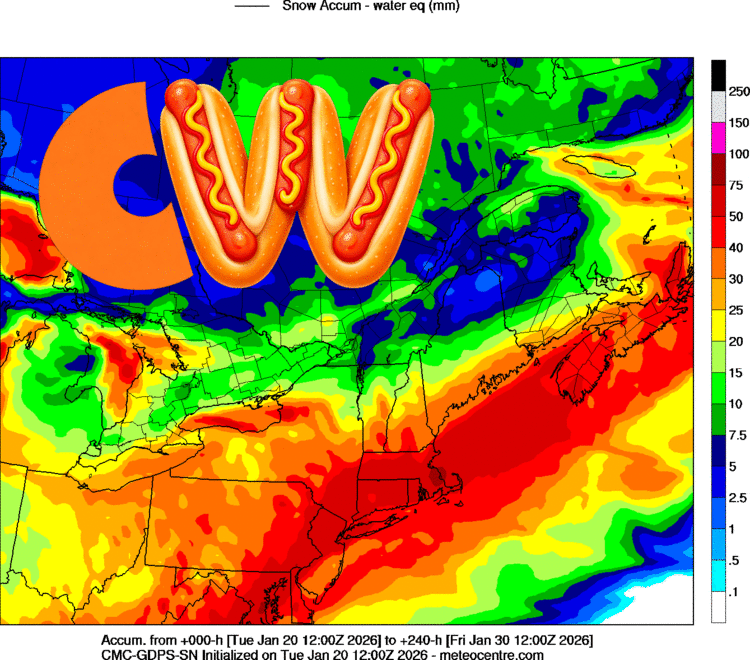
-
January 2026 regional war/obs/disco thread
dendrite replied to Baroclinic Zone's topic in New England
We’ve had Amex shows after the move from Eastern. But Randy only hosts shows when they get big events in DC so shows are like unicorns now. -
January 2026 regional war/obs/disco thread
dendrite replied to Baroclinic Zone's topic in New England
Stay up and make a 5th? -
January 2026 regional war/obs/disco thread
dendrite replied to Baroclinic Zone's topic in New England
Randy hosted them all -
January 2026 regional war/obs/disco thread
dendrite replied to Baroclinic Zone's topic in New England
I will facetime but it’s $100 the first minute and $50 for each additional minute. 1-900-WEENIES -
January 2026 regional war/obs/disco thread
dendrite replied to Baroclinic Zone's topic in New England
Hopefully they make us the 11th province. -
January 2026 regional war/obs/disco thread
dendrite replied to Baroclinic Zone's topic in New England
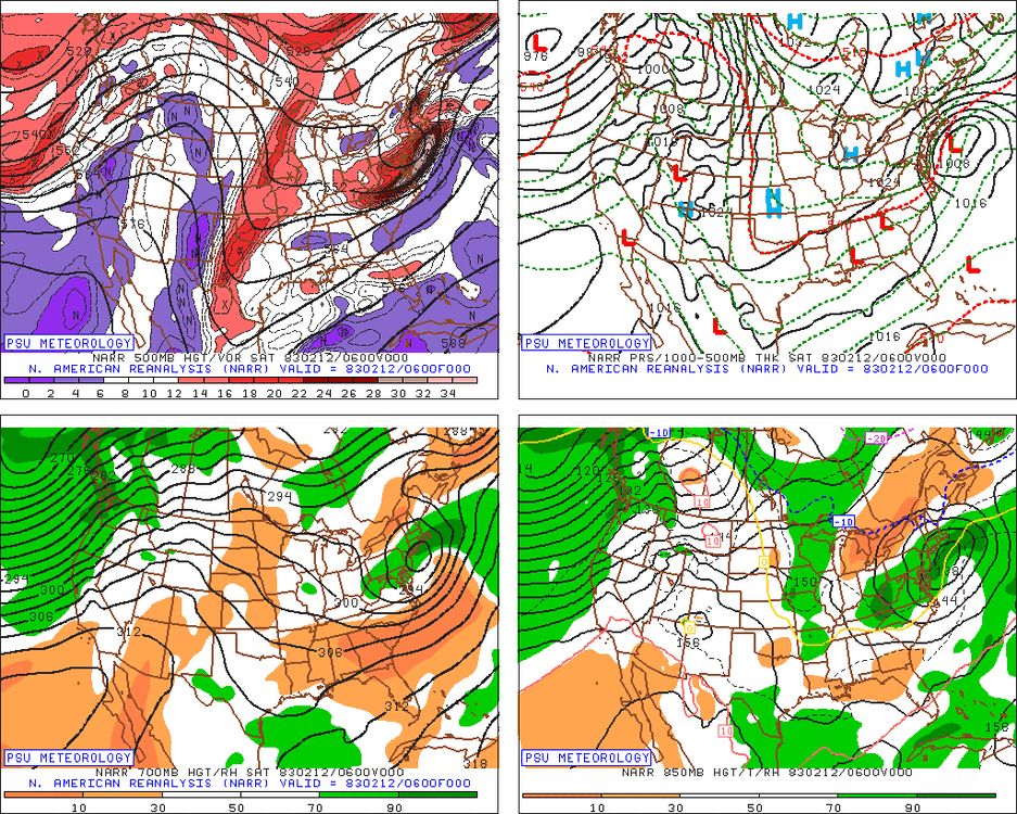
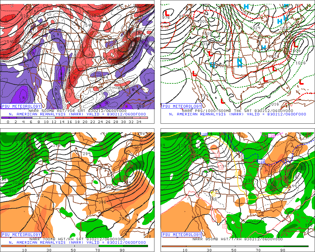
That upper level look screams sig event despite what the sfc reflection is. Still a lot to iron out, but just keep H5 looking like that. -
January 2026 regional war/obs/disco thread
dendrite replied to Baroclinic Zone's topic in New England
Not Titans Jan 04 cold but that would’ve been up there in the top 5 or 10 I would think. -
January 2026 regional war/obs/disco thread
dendrite replied to Baroclinic Zone's topic in New England
Too bad the Pats didn’t get the 1 seed. That would’ve been a cold game Sunday. -
January 2026 regional war/obs/disco thread
dendrite replied to Baroclinic Zone's topic in New England
Mark Mancuso was still hitting 2-5” in the interior at 630am that morning. I ended up with 18” (no clearing) in Auburn, NH. -
January 2026 regional war/obs/disco thread
dendrite replied to Baroclinic Zone's topic in New England
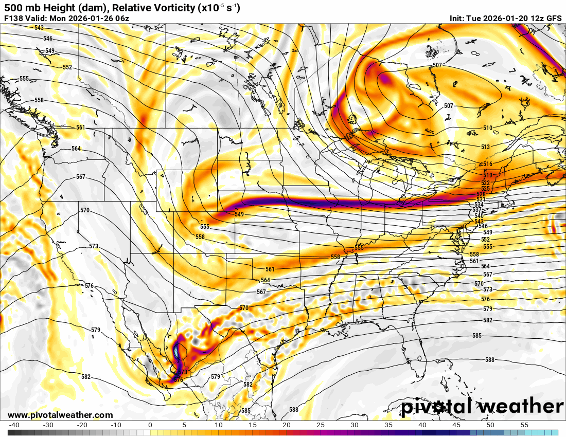
It’s like the purple teletubby waving to him offshore. -
January 2026 regional war/obs/disco thread
dendrite replied to Baroclinic Zone's topic in New England
Pump those heights
-
January 2026 regional war/obs/disco thread
dendrite replied to Baroclinic Zone's topic in New England
Yeah good bump N on the goofus -
Yeah. A reasonable estimate is better than accepting obviously bad data. Just take an avg of cocorahs ratios in the area and apply it to the accepted snow total for the site. It isn’t difficult.
-
January 2026 regional war/obs/disco thread
dendrite replied to Baroclinic Zone's topic in New England
Let’s get it to Quebec -
Nevermind…Jan 22 I assume. Yeah it’s likely undercatch from wind.
-
Which event is this?
-
January 2026 regional war/obs/disco thread
dendrite replied to Baroclinic Zone's topic in New England
That euro suite is definitely intriguing…a lot more ridging in the northeast. -
January 2026 regional war/obs/disco thread
dendrite replied to Baroclinic Zone's topic in New England
4th straight morning clearing snow…0.2” 6.7° -
January 2026 regional war/obs/disco thread
dendrite replied to Baroclinic Zone's topic in New England
Pretty good vortmax on that sucker despite the gph field looking meh