dendrite
-
Posts
72,992 -
Joined
Content Type
Profiles
Blogs
Forums
American Weather
Media Demo
Store
Gallery
Everything posted by dendrite
-

September vibes - Last 90s for some, 1st frost for others
dendrite replied to tamarack's topic in New England
43.9° here -
September vibes - Last 90s for some, 1st frost for others
dendrite replied to tamarack's topic in New England
How is Mark Morgarbage’s record weak arctic PV going? -
September vibes - Last 90s for some, 1st frost for others
dendrite replied to tamarack's topic in New England
No they all did -
September vibes - Last 90s for some, 1st frost for others
dendrite replied to tamarack's topic in New England
Guidance really lost that BD idea. What a stretch for late season warm weather enthusiasts incoming. -
September vibes - Last 90s for some, 1st frost for others
dendrite replied to tamarack's topic in New England
Potted plant season is coming to an end. Stein is just not phased by the dryness in fall like he is in spring. -
September vibes - Last 90s for some, 1st frost for others
dendrite replied to tamarack's topic in New England
Why not places where people work, play, and live? -
September vibes - Last 90s for some, 1st frost for others
dendrite replied to tamarack's topic in New England
He hasn’t been above 78° since 8/28. -
14th Lawn and Garden Thread P Allen Smith 2024
dendrite replied to Damage In Tolland's topic in New England
Not sure what you were expecting when you got these
-
14th Lawn and Garden Thread P Allen Smith 2024
dendrite replied to Damage In Tolland's topic in New England
MPMGW Letting the grass and natives grow now means you let your roof cave in. -
September vibes - Last 90s for some, 1st frost for others
dendrite replied to tamarack's topic in New England
DJF even better -
14th Lawn and Garden Thread P Allen Smith 2024
dendrite replied to Damage In Tolland's topic in New England
Haven’t thought about it. The peaches on that tree suck anyway. I only get fruit set about once every 5 years. -
14th Lawn and Garden Thread P Allen Smith 2024
dendrite replied to Damage In Tolland's topic in New England
Yeah they got all of mine too. -
September vibes - Last 90s for some, 1st frost for others
dendrite replied to tamarack's topic in New England
Could be a little chilly to start next week…especially ENE…if we get that BD. -
September vibes - Last 90s for some, 1st frost for others
dendrite replied to tamarack's topic in New England
Yeah I'm not adding a forum-wide reaction to something that only our subregion understands. Anyway...finally up to 60F. 60/41 -
September vibes - Last 90s for some, 1st frost for others
dendrite replied to tamarack's topic in New England
Requires a forum software upgrade and that's all John. -
September vibes - Last 90s for some, 1st frost for others
dendrite replied to tamarack's topic in New England
Mr Hanky will probably get abused and I'll have to drop it, but the Ray Combs X may stay. -
September vibes - Last 90s for some, 1st frost for others
dendrite replied to tamarack's topic in New England
What I do understand is that everyone bitches about their lawn every year whether it's wet or dry. -
September vibes - Last 90s for some, 1st frost for others
dendrite replied to tamarack's topic in New England
Yeah walking out to 48° with wind this morning was a shock. 30° and -FZDZ on the Rockpile. -
September vibes - Last 90s for some, 1st frost for others
dendrite replied to tamarack's topic in New England
I wish we could turn off that Labrador current nonsense. -
September vibes - Last 90s for some, 1st frost for others
dendrite replied to tamarack's topic in New England
0.38” here last night and we’re waterlogged. Soil moisture is 18cb. Highest of the warm season. -
September vibes - Last 90s for some, 1st frost for others
dendrite replied to tamarack's topic in New England
Stay safe -
September vibes - Last 90s for some, 1st frost for others
dendrite replied to tamarack's topic in New England
Still some heat taint on models in the extended but like I said yesterday…we just bounce around from WAN to AN. It’ll be interesting to see our fall weather once we start getting ice free arctic summers. We’ll probably extend avg first freezes out another 2-3 weeks from where we are now. -
September vibes - Last 90s for some, 1st frost for others
dendrite replied to tamarack's topic in New England
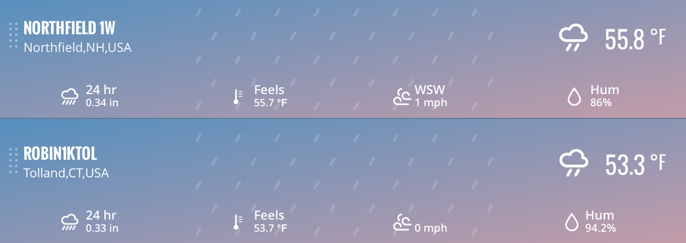
You had 0.33” last night. Not too bad. -
September vibes - Last 90s for some, 1st frost for others
dendrite replied to tamarack's topic in New England
It’s September. Not as big of a deal as MJJ. Had 3/8” up here though…glad we here. -
September vibes - Last 90s for some, 1st frost for others
dendrite replied to tamarack's topic in New England
+0.01