SACRUS
-
Posts
16,111 -
Joined
-
Last visited
Content Type
Profiles
Blogs
Forums
American Weather
Media Demo
Store
Gallery
Everything posted by SACRUS
-
Extreme Cold, Snow & Sleet: SECS 1/24 - 1/26
SACRUS replied to TriPol's topic in New York City Metro
-
Extreme Cold, Snow & Sleet: SECS 1/24 - 1/26
SACRUS replied to TriPol's topic in New York City Metro
RGM -
Extreme Cold, Snow & Sleet: SECS 1/24 - 1/26
SACRUS replied to TriPol's topic in New York City Metro
-
Extreme Cold, Snow & Sleet: SECS 1/24 - 1/26
SACRUS replied to TriPol's topic in New York City Metro
1/24 00z RGEM -
-
Extreme Cold, Snow & Sleet: SECS 1/24 - 1/26
SACRUS replied to TriPol's topic in New York City Metro
Cold push -
Extreme Cold, Snow & Sleet: SECS 1/24 - 1/26
SACRUS replied to TriPol's topic in New York City Metro
The soon to replace NAM (q2?) RRFS - Rapid Refresh Forecast System 1/24 00z -
Extreme Cold, Snow & Sleet: SECS 1/24 - 1/26
SACRUS replied to TriPol's topic in New York City Metro
Updated -
Extreme Cold, Snow & Sleet: SECS 1/24 - 1/26
SACRUS replied to TriPol's topic in New York City Metro
1/24 00z ICON total storm QPF Total snow / Frz (10:1) -
Extreme Cold, Snow & Sleet: SECS 1/24 - 1/26
SACRUS replied to TriPol's topic in New York City Metro
-
Extreme Cold, Snow & Sleet: SECS 1/24 - 1/26
SACRUS replied to TriPol's topic in New York City Metro
-
Extreme Cold, Snow & Sleet: SECS 1/24 - 1/26
SACRUS replied to TriPol's topic in New York City Metro
1/24 00z ICON run v -
Extreme Cold, Snow & Sleet: SECS 1/24 - 1/26
SACRUS replied to TriPol's topic in New York City Metro
1/24 00Z NYC QPF / Snow (Frz) SREF (mean): 1.3 / 9.7 NAM: 1.2 / 4.7 ICON: 1.4 / 8.1 RGEM: 1.2 / 9.5 GFS: 1/3 / 11.1 GFS AI AIGFS: 1.1 / 9.8 GEFS: 1.5 / 10.3 UKMET: 0.9 / 7.4 GGEM: 1.3 / 9.1 Euro : 1.2 / 10.2 Euro AI AIFS: 1,2 / 11.0 -
Extreme Cold, Snow & Sleet: SECS 1/24 - 1/26
SACRUS replied to TriPol's topic in New York City Metro
1/24 00z NAM total QPF storm Total snow / sleet (10:1) -
Extreme Cold, Snow & Sleet: SECS 1/24 - 1/26
SACRUS replied to TriPol's topic in New York City Metro
-
Extreme Cold, Snow & Sleet: SECS 1/24 - 1/26
SACRUS replied to TriPol's topic in New York City Metro
GRAF refers to an AI-based global weather forecasting model developed by NOAA (GSL) and collaborators, and the name stands for: GRAF = Global Regression AI Forecast model It’s part of the new generation of machine-learning weather models, similar in spirit to GraphCast or Pangu, but developed inside the NOAA ecosystem. What is the GRAF model? GRAF is a pure machine-learning global forecast model that: Learns atmospheric evolution from historical reanalysis data Produces global forecasts without explicitly solving physical equations Uses regression-based deep learning to predict future atmospheric states Think of it as: “AI learning how the atmosphere usually evolves, then extrapolating forward.” Key characteristics Global coverage AI / ML-based (no traditional physics core) Predicts large-scale fields (e.g., 500 mb heights, winds, temps, MSLP) Extremely fast compared to physics models Designed primarily for pattern and flow prediction What GRAF is good at Large-scale synoptic pattern recognition Jet stream placement Ridge / trough evolution Medium-range guidance (Days 3–7) This makes it useful for: Pattern forecasting Ensemble support Early signal detection What GRAF is NOT good at Precipitation amounts Snowfall totals Precipitation type Mesoscale features (banding, fronts) Boundary-layer processes -
Extreme Cold, Snow & Sleet: SECS 1/24 - 1/26
SACRUS replied to TriPol's topic in New York City Metro
-
Extreme Cold, Snow & Sleet: SECS 1/24 - 1/26
SACRUS replied to TriPol's topic in New York City Metro
-
Extreme Cold, Snow & Sleet: SECS 1/24 - 1/26
SACRUS replied to TriPol's topic in New York City Metro
-
Extreme Cold, Snow & Sleet: SECS 1/24 - 1/26
SACRUS replied to TriPol's topic in New York City Metro
1/24 00z NAM -
Extreme Cold, Snow & Sleet: SECS 1/24 - 1/26
SACRUS replied to TriPol's topic in New York City Metro
And total QPF -
Records: Highs: EWR: 62 (2018) NYC: 63 (1874) LGA: 62 (1967) JFK: 56 (1967) Lows: EWR: -4 (1936) NYC: -3 (1936) LGA: 3 (1976) JFK: 2 (1976) Historical: 1780 - The coldest day of the coldest month of record in the northeastern U.S. A British Army thermometer in New York City registered a reading of 16 degrees below zero. During that infamous hard winter the harbor was frozen solid for five weeks, and the port was cut off from sea supply. (David Ludlum) 1916: Browning, Montana, saw the temperature plummet 100 degrees in 24 hours on January 23-24, from a relatively mild 44 to a bone-chilling 56 degrees below zero. 1969: An F4 tornado cut a 120-mile long path from Jefferson through Copiah, Simpson, Smith, Scott, and Newton Counties in Mississippi, killing 32 and injuring 241 others. Property damage was estimated at $2 million. An inbound Delta Airlines aircraft reported a hook echo on its scope with this storm. 1971 - The temperature at Prospect Creek, AK, plunged to 80 degrees below zero, the coldest reading of record for the United States. (David Ludlum) 1971: Alaska, and the US, lowest official temp, -80F (-62.2C), was set at Prospect Creek, a Trans-Alaska Oil Pipeline construction camp. Fun fact: the low was initially recorded as -79F but adjusted after thermometer calibration 1987 - Strong winds ushered bitterly cold air into the north central U.S., and produced snow squalls in the Great Lakes Region. Snowfall totals in northwest Lower Michigan ranged up to 17 inches in Leelanau County. Wind chill temperatures reached 70 degrees below zero at Sault Ste Marie MI and Hibbing MN. (National Weather Summary) (Storm Data) 1988 - Northeastern Colorado experienced its most severe windstorm in years. A wind gust to 92 mph was recorded at Boulder CO before the anenometer blew away, and in the mountains, a wind gust to 120 mph was reported at Mines Peak. The high winds blew down a partially constructed viaduct east of Boulder, as nine unanchored concrete girders, each weighing forty-five tons, were blown off their supports. (National Weather Summary) (Storm Data) 1989 - Low pressure brought heavy snow to Wyoming, with 18 inches reported at the Shoshone National Forest, and 17 inches in the Yellowstone Park area. Gunnison CO, with a low of 19 degrees below zero, was the cold spot in the nation for the twelfth day in a row. (National Weather Summary) (Storm Data) 1990 - A Pacific cold front brought strong and gusty winds to the northwestern U.S. Winds in southeastern Idaho gusted to 62 mph at Burley. Strong winds also prevailed along the eastern slopes of the northern and central Rockies. Winds in Wyoming gusted to 74 mph in Goshen County. (National Weather Summary) (Storm Data)
-
32/ -1 and dropping. Cold settling in - storm Sunday - Mon - Icebox through the ground hogs day festivities (at least). Looks to be sub freezing the next 180 hours or more. Storm chances in the 1/31 - Ground hogs day period. Moderation beyond feb 5.
-
Extreme Cold, Snow & Sleet: SECS 1/24 - 1/26
SACRUS replied to TriPol's topic in New York City Metro
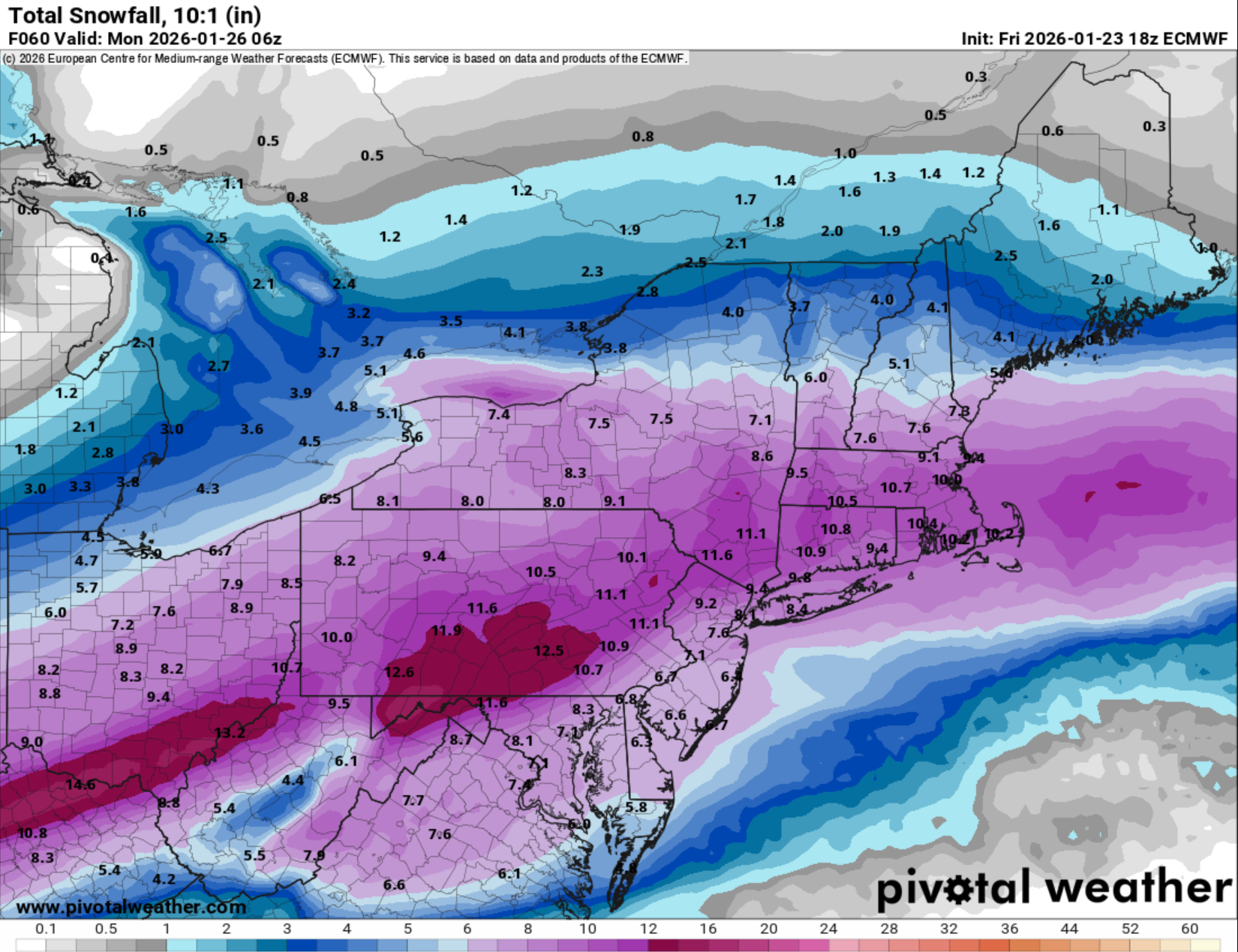
1/23 18Z Euro Snowfall (10:1)
-
Extreme Cold, Snow & Sleet: SECS 1/24 - 1/26
SACRUS replied to TriPol's topic in New York City Metro
1/23 18z Euro AI AIFS otal QPF storm Total snow / sleet f (10:1)