

SACRUS
-
Posts
16,202 -
Joined
-
Last visited
Content Type
Profiles
Blogs
Forums
American Weather
Media Demo
Store
Gallery
Posts posted by SACRUS
-
-
Dep through the 14th
NYC: -3.6
LGA: -3.5
EWR: -2.2
JFK: -1.0 -
Records:
Highs:
EWR: 68 (2015)
NYC: 68 (2015)
LGA: 67 (2008)
JFK: 64 (2015)
Lows:
EWR: 12 (2005)
NYC: 8 (1874)
LGA: 15 (1962)
JFK: 15 (1962)Historical:
1924 - The temperature at Helena, MT, plunged 79 degrees in 24 hours, and 88 degrees in 34 hours. The mercury plummeted from 63 above to 25 below zero. At Fairfield MT the temperature plunged 84 degrees in just 12 hours, from 63 at Noon to 21 below zero at midnight. (David Ludlum)
1987 - A powerful storm spread heavy snow from the Southern High Plains to the Middle Mississippi Valley, and produced severe thunderstorms in the Lower Mississippi Valley. During the evening a tornado hit West Memphis TN killing six persons and injuring two hundred others. The tornado left 1500 persons homeless, and left all of the residents of Crittendon County without electricity. Kansas City MO was blanketed with 10.8 inches of snow, a 24 hour record for December, and snowfall totals in the Oklahoma panhandle ranged up to 14 inches. Strong winds, gusting to 63 mph at Austin TX, ushered arctic cold into the Great Plains, and caused considerable blowing and drifting of snow. (Storm Data) (The National Weather Summary)
1988 - Blowing snow was reported in western Kansas, as snow and gusty winds plagued the Central Rockies and Central High Plains. Colorado Springs CO reported thirteen inches of snow. Low pressure in Wisconsin brought heavy snow to the Lake Superior snowbelt area, with 22 inches reported at Marquette MI. (Storm Data) (The National Weather Summary)
1989 - High winds and heavy snow prevailed from Montana to Colorado. Snowfall totals in Wyoming ranged up to 20 inches at Burgess Junction, leaving up to 48 inches on the ground in the northeast sections of the state. Wind gusts in Colorado reached 87 mph south of the town of Rollinsville. Strong northwesterly winds continued to produce heavy snow squalls in the Great Lakes Region. Totals in northeastern Lower Michigan ranged up to 29 inches at Hubbard Lake, with 28 inches reported at Posen. Two day totals in northeastern Wisconsin ranged up to thirty inches. (Storm Data) (The National Weather Summary)
2006 - The Hanukkah Eve Wind Storm of 2006 caused storm to hurricane-force wind gusts and heavy rainfall hit the Pacific Northwest and southern British Columbia. Damage estimates in Washington and Oregon totaled $220 million. Over 1.8 million residences and businesses without power. 18 people were killed, most of whom died of carbon monoxide poisoning in the days following the storm because of improper use of barbecue cookers and generators indoors.
2010 - A rare tornado struck the small town of Aumsville, Oregon, tearing roofs off buildings, hurling objects into vehicles and homes and uprooting trees. No one was injured but the destruction left behind was severe. The National Weather Service classified the tornado as an EF2 with wind speeds of 110-120 mph and they said the tornado's damage trail was five miles long and 150 yards wide. 50 houses in Aumsville and the surrounding county area were affected, with 10 of them being unsuitable for occupancy. (KATU)
-
27 / 16 mostly cloudy a drone or two, off a low of 19. Warmer/wetter the next 5 days. Rain later Sun/Mon and Wed with another 050 - 1.00 for the area. Trough comes in by the end of this week and much colder Saturday through about Christmas. Rebound warmer to close the month overall.
-
 1
1
-
-
As we march towards the winter solstice and continue to lose daylight (from later sunrises), the sunset is a minute later from the 4:28 PM low and is now 4:29.
-
1
-
-
30 minutes ago, the_other_guy said:
when was the last time we had a below normal December?
That’s an impressive on its own right. Looks like a lock now
2019, 2017
EWR:
Dec dep
2023: +6.3
2022: +.03
2021: + 6.5
2020: 0
2019: - 0.4
2018: +1.4
2017: - 3.7-
 1
1
-
-
Another inch or so of rain in the next week mainly Sun/Mon and Wed.

-
1
-
-
NYC
2013: 5 inches of snow mixed with and changed to heavy rain. Total liquid 1.46 inches. -
Records:
Highs:
EWR: 67 (2015)
NYC: 67 (2015)
LGA: 64 (2015)
JFK: 61 (2015)
Lows:
EWR: 11 (2005)
NYC: 12 (1976)
LGA: 12 (1976)
JFK: 12 (1976)
Historical:1924 - The temperature at Helena, MT, plunged 79 degrees in 24 hours, and 88 degrees in 34 hours. The mercury plummeted from 63 above to 25 below zero. At Fairfield MT the temperature plunged 84 degrees in just 12 hours, from 63 at Noon to 21 below zero at midnight. (David Ludlum)
1952: Trace of snow or sleet at or near Pensacola, Crestview, DeFuniak Springs, Quincy, Carrabelle, Tallahassee, St. Marks, Monticello, Madison, Mayo, Live Oak, Lake City, Glen St. Mary, and Hilliard in Florida. Frozen precipitation occurred before noon at most points, but happened in the afternoon at Mayo and Lake City and near Hilliard. Temperatures were above freezing and snow or sleet melted as it fell.
1987 - A powerful storm spread heavy snow from the Southern High Plains to the Middle Mississippi Valley, and produced severe thunderstorms in the Lower Mississippi Valley. During the evening a tornado hit West Memphis TN killing six persons and injuring two hundred others. The tornado left 1500 persons homeless, and left all of the residents of Crittendon County without electricity. Kansas City MO was blanketed with 10.8 inches of snow, a 24 hour record for December, and snowfall totals in the Oklahoma panhandle ranged up to 14 inches. Strong winds, gusting to 63 mph at Austin TX, ushered arctic cold into the Great Plains, and caused considerable blowing and drifting of snow. (Storm Data) (The National Weather Summary)
1988 - Blowing snow was reported in western Kansas, as snow and gusty winds plagued the Central Rockies and Central High Plains. Colorado Springs CO reported thirteen inches of snow. Low pressure in Wisconsin brought heavy snow to the Lake Superior snowbelt area, with 22 inches reported at Marquette MI. (Storm Data) (The National Weather Summary)
1989 - High winds and heavy snow prevailed from Montana to Colorado. Snowfall totals in Wyoming ranged up to 20 inches at Burgess Junction, leaving up to 48 inches on the ground in the northeast sections of the state. Wind gusts in Colorado reached 87 mph south of the town of Rollinsville. Strong northwesterly winds continued to produce heavy snow squalls in the Great Lakes Region. Totals in northeastern Lower Michigan ranged up to 29 inches at Hubbard Lake, with 28 inches reported at Posen. Two day totals in northeastern Wisconsin ranged up to thirty inches. (Storm Data) (The National Weather Summary)
1997:Central Mississippi and western Alabama saw significant snowfall of 4 to 8 inches on this day. In Mississippi, this was one of the heavier snowfalls to occur since 1929. The weight of the snow caused limbs of trees to break, which knocked down power lines.
2006 - The Hanukkah Eve Wind Storm of 2006 caused storm to hurricane-force wind gusts and heavy rainfall hit the Pacific Northwest and southern British Columbia. Damage estimates in Washington and Oregon totaled $220 million. Over 1.8 million residences and businesses without power. 18 people were killed, most of whom died of carbon monoxide poisoning in the days following the storm because of improper use of barbecue cookers and generators indoors.
2010 - A rare tornado struck the small town of Aumsville, Oregon, tearing roofs off buildings, hurling objects into vehicles and homes and uprooting trees. No one was injured but the destruction left behind was severe. The National Weather Service classified the tornado as an EF2 with wind speeds of 110-120 mph and they said the tornado's damage trail was five miles long and 150 yards wide. 50 houses in Aumsville and the surrounding county area were affected, with 10 of them being unsuitable for occupancy. (KATU)
-
26 / 11 off a low of 16 (coldest since Feb 18th/19) and a clear night for the star and drone gazers. Colder than normal one more day - stuck in near 40 / mid-upper 30s. Warmer / wetter Sun - Tue AM 0.25 - 0.50. Much warmer Tue near / low 60s. Additional rainfall Wed with near to above normal through Friday. Colder Sat and through about Christmas. Should see a rebound to warmer ahead of quick colder period to balance our overall near to slightly above normal to close the month.
-
Just now, BobbyHolikWillFindYou said:
The OCD in me loves this.
Thats a rarity for sure
-
Departures through 12/12
NYC: -2.5
LGA: -2.4
EWR: -1.1
JFK: 0.1
-
Records:
Highs:
EWR: 68 (2015) first of many record highs that month / season
NYC: 67 (2015)
LGA: 63 (1946)
JFK: 70 (2015)
Lows:
EWR: 8 (1960)
NYC: 8 (1960)
LGA: 8 (1960)
JFK: 8 (1960)Historical:
1915 - A heavy snowstorm kicked off the snowiest winter in modern records for western New England. (The Weather Channel)
1962 - A severe Florida freeze occurred. Morning lows reached 35 degrees at Miami, 18 degrees at Tampa, and 12 degrees at Jacksonville. It was the coldest December weather of the 20th century and caused millions of dollars damage to crops and foliage. In Georgia, the morning low of 9 degrees below zero at Blairsville established a state record for the month of December. (David Ludlum) (The Weather Channel)
1987 - A major winter storm produced high winds and heavy snow in the Southern Rockies and the Southern High Plains. Snowfall totals in New Mexico ranged up to 25 inches at Cedar Crest, with up to three feet of snow reported in the higher elevations. Winds of 75 mph, with gusts to 124 mph, were reported northeast of Albuquerque NM. El Paso TX was buried under 22.4 inches of snow, including a single storm record of 16.8 inches in 24 hours. The snowfall total surpassed their previous record for an entire winter season of 18.4 inches. Record cold was experienced the next three nights as readings dipped into the single numbers. High winds ushering unseasonably cold air into the southwestern U.S. gusted to 100 mph at Grapevine CA. (The National Weather Summary) (Storm Data)
1988 - Low pressure off the Atlantic coast produced up to a foot of snow in eastern Nassau County and western Suffolk County of southeastern New York State. Mild weather prevailed across the western half of the country. Nine cities reported record high temperatures for the date, including Goodland KS with a reading of 74 degrees. (The National Weather Summary) (Storm Data)
1989 - Strong northwesterly winds, ushering bitterly cold arctic air into the central U.S., produced squalls with heavy snow in the Great Lakes Region. Snowfall totals in Upper Michigan ranged up to 24 inches at Manistique. Nine cities in Arkansas and Texas reported record low temperatures for the date, including Calico Rock AR with a reading of 4 degrees above zero. (Storm Data) (The National Weather Summary)
2002 - A powerful Pacific storm system plowed into the western United States during the 13th-16th, producing high winds, heavy rains, significant mountain snowfall and causing 9 deaths (Associated Press). Rainfall amounts exceeding 10 inches occurred in parts of California, and wind gusts over 45 mph produced up to 1.9 million power outages during the period (Pacific Gas & Electric).
-
30 / 7 off a low of 22 here. Cold the next 36 hours. Warmer wetter replay of the last week Sun - Tue up to 0.75. colder period by next sunday 21st and into /through Christmas with big WC ridge. Storms and each storm's potential should be interesting to track. Beyond Christmas near / warmer than normal rebound by the close of the month.

-
1
-
-
Records:
Highs:
EWR: 68 (1931)
NYC: 68 (1931)
LGA: 66 (2015)
JFK: 64 (2015)
Lows:
EWR: 6 (1988)
NYC: 5 (1988)
LGA: 8 (1988)
JFK: 7 (1988)
Historical:
1882 - Portland, OR, was drenched with 7.66 inches of rain, a record 24 hour total for that location. (12th-13th) (The Weather Channel)
1960 - The first of three Middle Atlantic snowstorms produced a foot of snow at Baltimore MD. A pre-winter blizzard struck the northeastern U.S. producing wind gusts as high as 51 mph, along with 16 inches of snow at Nantucket MA, and 20 inches at Newark NJ. (David Ludlum)
1969 - The worst tornado of record for western Washington State tracked south of Seattle, traveling five miles, from Des Moines to Kent. The tornado, 50 to 200 yards in width, began as a waterspout over Puget Sound. One person was injured and the tornado caused half a million dollars damage. (The Weather Channel)
1987 - While a developing winter storm began to spread snow across New Mexico into Colorado, high winds ushered unseasonably cold air into the southwestern states. Winds in California gusted to 60 mph in the Sacramento River Delta, and in the San Bernardino Valley. (The National Weather Summary)
1988 - Cold arctic air spread from the Great Lakes Region to the Appalachian Region. Twenty-five cities, mostly in the northeastern U.S., reported record low temperatures for the date. The low of 12 degrees below zero at Albany NY was their coldest reading of record for so early in the season. Saranac Lake NY was the cold spot in the nation with a low of 28 degrees below zero. (The National Weather Summary)
1989 - A winter storm produced snow from northern Mississippi to the Middle Atlantic Coast, with 10.5 inches reported at Powhatan VA. Heavy snow whitened the Black Hills of South Dakota, with 36 inches reported at Deer Mountain. Thirteen cities in the north central U.S., from Minnesota to Texas, reported record low temperatures for the date, including Duluth MN and Yankton SD with morning lows of 22 degrees below zero. (The National Weather Summary) (Storm Data)
1995 - A severe coastal storm is blamed for five deaths and loss of power to over one million people in Oregon and Washington. Winds at Sea Lion Caves near Florence topped out at 119 mph before problems developed with the anemometer. In Newport, a gust of 107 mph occurred downtown, while Astoria and Cape Blanco also had gusts of over 100 mph. Astoria's air pressure dropped as low as 28.53 inches, an all-time record (and comparable to the central pressure of a Category 2 hurricane!). Gusts in the Willamette Valley exceeded 60 mph.
2008 - A significant ice storm wreaked havoc across New York and New England on December 12, disrupting electricity and leaving over 1 million homes and businesses without power. New Hampshire alone had as many as 320,000 residents without power, which according to reports it was described as the worst outages in 30 years (Reuters). Four fatalities were reported and parts of Massachusetts, New Hampshire, New York, and Maine declared a state of emergency (BBC News).
-
Rainfall Tue/Wed:
LGA: 1.12
NYC: 1.11
JFK: 1.01
EWR: 0.92
-
1
-
-
40 / 20 sunny and windy Gusts to 22MPH here. 0.87 in the bucket Tue/Wed and 1.01 for the week. Colder today - Sat then warmer Sun - next Friday. Additional rainfall next week eating away the deficit 0.25 - 0.50. All eyes on the 12/21 - 12/31 period. Close warm- normal and wet, colder and drier , or christmas snows.
-
1
-
-
1960: 15.2 inches of snow NYC and the largest early snowfall.
-
2
-
-
Records:
Highs:
EWR: 69 (2021)
NYC: 66 (2021)
LGA: 67 (2021)
JFK: 67 (1971)
Lows:
EWR: 11 (1977)
NYC: 6 (1880)
LGA: 14 (1988)
JFK: 13 (1988)Historical:
1932 - Very cold weather prevailed along the West Coast. San Francisco received 0.8 inch of snow, and at the airport the temperature dipped to 20 degrees. At Sacramento CA, the mercury dipped to 17 degrees to establish an all-time record low for that location. Morning lows were below freezing from the 9th to the 15th at Sacramento, and the high on the 11th was just 34 degrees. The cold wave dealt severe damage to truck crops and orange groves in the Sacramento Valley. (David Ludlum) (The Weather Channel)
1987 - Low pressure over southwestern Ontario, Canada, brought snow and gusty winds to the North Central U.S. Winds gusted to 62 mph at Riverton WY. Snow and high winds in eastern North Dakota reduced visibilities to less than one hundred feet at times. Warm weather prevailed across the Southern Plains Region. Half a dozen cities reported record high temperatures for the date, including Del Rio TX with a reading of 89 degrees. Laredo TX and Kingsville TX tied for honors as hot spot in the nation with afternoon highs of 92 degrees. (The National Weather Summary)
1988 - Arctic cold invaded the central and eastern U.S. Sault Ste Marie MI reported a record low of 14 degrees below zero, and International Falls MN was the cold spot in the nation with a low of 25 degrees below zero. Temperatures remained below zero all day over parts of eastern Upper Michigan and northern New England. (The National Weather Summary)
1989 - Strong Santa Ana winds developed across southern California and parts of central California. Winds in Kern County of central California gusted to 100 mph near Grapevine. The high winds reduced visibilities to near zero in the desert areas, closing major interstate highways east of Ontario CA. (Storm Data) (The National Weather Summary)
1992:A complex storm system moved eastward from the Gulf Coast of Texas to eastern Georgia on December 9 and 10th. In the next 24 hours, the low-pressure system moved to the Chesapeake Bay and rapidly intensified. This system produced gale force winds with gusts exceeding hurricane force affected not only the Mid-Atlantic coastline but also as far southwest as the southern Appalachians where trees were downed and roofs damaged. This storm also produced 20 to 30-foot waves in Massachusetts on December 12 and 13th. Precipitation amounts varied considerably. Rainfall amounts of 8 inches occurred in southeastern Massachusetts, while several areas in New York, Massachusetts, Pennsylvania, and Maryland recorded more than 30 inches of snow. Precipitation ended during the evening hours on the 12th. Ten deaths resulted from the storm with insured losses totaling near $850 million and non-insured losses near $2 billion.
2008 - A rare snowstorm swept across parts of south Louisiana and Mississippi, blanketing the area with snow. Nearly 8 inches of snow fell over parts of Louisiana. These conditions caused schools and bridges to close and left thousands of residents without power (Associated Press). (NCDC)
2010 - The "Pineapple Express" - a meteorological event where southwest winds bring warm, moist air to the U.S. West Coast - produced record rainfall to the Pacific Northwest during December 11th-12th. Seattle experienced record daily rainfall two days in a row. The Seattle-Tacoma International Airport recorded 1.42 inches of rain on the 11th, breaking the old daily record of 1.32 inches set in 1955. The next day, 2.19 inches fell, breaking the daily record of 1.70 inches set in 1966. The Stillaguamish River in western Washington state reached 21.06 feet at Arlington, tying the record set in November 2006. Flood stage for the river is 14 feet. The storm system also brought record warmth to the area. On December 14th, the temperature at Seattle-Tacoma International Airport reached 57, breaking the old daily record of 55 set in 2004. (NCDC)
-
EC warmest ahead of front and trough
-
65 / 61 cloudy and some light rain. 0.23 in the bucket and another 1 - 1.5 inches potentially to come. Breezy with a southerly wind. Colder Thu - Sat before more rain warmer Sun - Tue. Overall near to slightly above normal into mid month and a bit beyond.
-
1
-
-
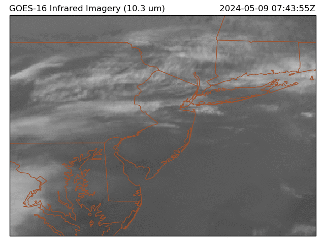
leading area of Rain pushing into E PA
-
-
2
-
1
-
-
Records:
Highs:
EWR: 72 (1946)
NYC: 70 (1946)
LGA: 70 (1946)
JFK: 59 (2015)
Lows;EWR: 8 (1968)
NYC: 3 (1876)
LGA: 9 (1968)
JFK: 9 (1968)
Historical:1699 - A severe ice storm hit Boston, MA, causing much damage to orchards. (The Weather Channel)
1946 - The temperature at New York City soared to 70 degrees. (David Ludlum)
1949 - The barometric pressure at Las Vegas, NV, reached a record low reading of 29.17 inches (987.8 millibars). (The Weather Channel)
1987 - A cold front brought high winds to the eastern slopes of the Northern and Central Rockies. Winds gusted to 97 mph at Mines Peak CO. In Wyoming, up to a foot of snow blanketed the Teton Village Ski Resort, northwest of Jackson. Strong chinook winds in the Central High Plains Region, gusting to 61 mph at Scottsbluff NE, warmed temperatures to near 70 degrees. (Storm Data) (The National Weather Summary)
1988 - Squalls produced heavy snow in the Lower Great Lakes Region. Totals in northeastern Ohio ranged up to 14 inches at Harpersfield, and totals in western New York State ranged up to 14 inches at Sodus. In the snowbelt of Upper Michigan, the Ontonogon area reported two feet of snow in two days. (Storm Data) (The National Weather Summary)
1989 - Heavy snow fell across the northern and central mountains of Colorado, with 24 inches reported at Steamboat Springs. Six to twelve inches of snow fell in the Denver and Boulder area delaying plane flights and snarling traffic. Heavy snow also spread across the Central Plains into the Mississippi Valley. Winner SD received 11 inches of snow, and more than ten inches of snow was reported north of Sioux City IA. (The National Weather Summary) (Storm Data)
1992 - A slow-moving Nor'easter storm batters the northeast U.S. coast killing 19 people.
-
Wet coasts
-
2
-

December 2024
in New York City Metro
Posted
The period 12/21 - 12/24 looks cold and like it could have negative departures -8 to -12 or more daily, more than yesterday and any of the opening 6 days this month which peaked at -10 in NYC and EWR.