


Caveman
-
Posts
219 -
Joined
-
Last visited
Content Type
Profiles
Blogs
Forums
American Weather
Media Demo
Store
Gallery
Everything posted by Caveman
-

Central PA - Jan 31 to Feb 2 Winter Storm
Caveman replied to MAG5035's topic in Upstate New York/Pennsylvania
5.1" new snow; 4.8" on ground at 7:00 am; 0.46" Liquid equivalent...Etters, N York County, PA -
Central PA - Jan 31 to Feb 2 Winter Storm
Caveman replied to MAG5035's topic in Upstate New York/Pennsylvania
SPC (Storm Prediction Center) website; mesoanalysis, upper air... https://www.spc.noaa.gov/exper/mesoanalysis/new/viewsector.php?sector=17# -
Central PA - Jan 31 to Feb 2 Winter Storm
Caveman replied to MAG5035's topic in Upstate New York/Pennsylvania
Even if 25% verified, will be some heartache with high water Super Bowl weekend when temps spike with another 1" of precip... -
Central PA - Jan 31 to Feb 2 Winter Storm
Caveman replied to MAG5035's topic in Upstate New York/Pennsylvania
Central PA...NYC is spit away and here is the screenshot from the model output...
-
Central PA - Jan 31 to Feb 2 Winter Storm
Caveman replied to MAG5035's topic in Upstate New York/Pennsylvania
-
Central PA - Jan 31 to Feb 2 Winter Storm
Caveman replied to MAG5035's topic in Upstate New York/Pennsylvania
Looks like the NAM told DeBlasio the atmosphere will not cooperate with his charge to re-open NYC this week!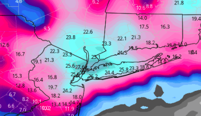
-
Central PA - Jan 31 to Feb 2 Winter Storm
Caveman replied to MAG5035's topic in Upstate New York/Pennsylvania
The "B" in Miller B represents "bitch" of a prognostication... -
Central PA - Jan 31 to Feb 2 Winter Storm
Caveman replied to MAG5035's topic in Upstate New York/Pennsylvania
Way too far in time and space...HRRR is excellent with convection within 6 hours of initialization...not with synoptic physics of the atmosphere...IMHO -
I was just up to Towanda yesterday and there was very little to no ice in the river. Ice dams should not be a concern. Obviously they do have quite a snowpack up in that region however which is not good with these high dew points and mild temps!
-
That greater radar reflectivity could indicate sleet mixing in which is the time frame of that most likely occurring...still likely one for the books!
-
Hello all...I was wondering if anyone knows about the MAD WEATHER Teleconnections website? Has it been moved to a different web address or has it been discontinued? It was very helpful and one I often looked to during the cold season. Any insights would be greatly appreciated!

