
Caveman
-
Posts
219 -
Joined
-
Last visited
Content Type
Profiles
Blogs
Forums
American Weather
Media Demo
Store
Gallery
Everything posted by Caveman
-
Central PA Winter 25/26 Discussion and Obs
Caveman replied to MAG5035's topic in Upstate New York/Pennsylvania
That is an excellent point concerning the skew of the 15 analog means by the 2 "outliers". It would be very interesting to be able to produce a map that does show the top 15 w/out the 2 "outliers"...but that is above my pay grade! -
Central PA Winter 25/26 Discussion and Obs
Caveman replied to MAG5035's topic in Upstate New York/Pennsylvania
This is from the CIPS website...kinda fun to peruse... https://www.eas.slu.edu/CIPS/ANALOG/analog.php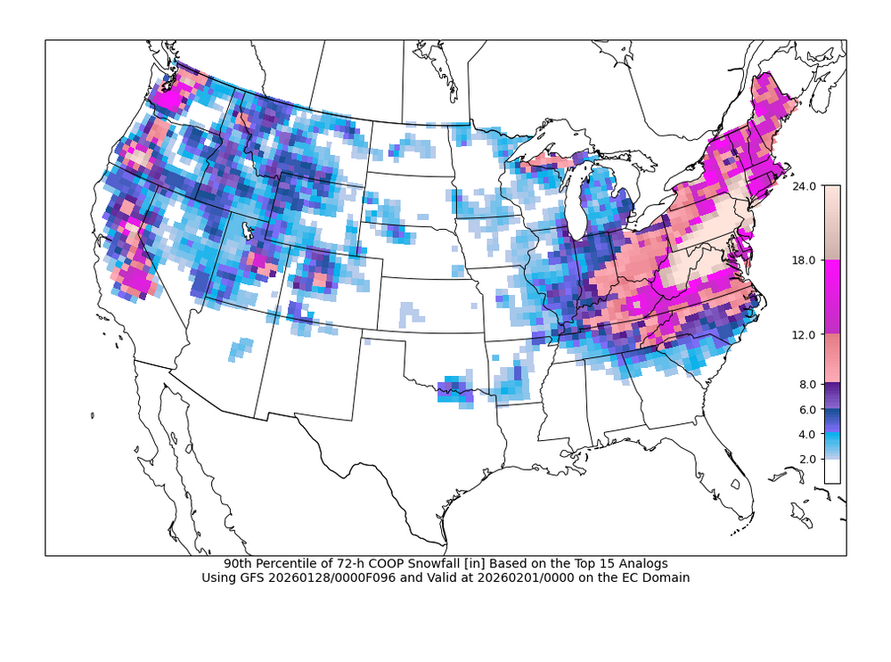
-
Central PA Winter 25/26 Discussion and Obs
Caveman replied to MAG5035's topic in Upstate New York/Pennsylvania
Same here in Valley Green, northern York County. -
Central PA Winter 25/26 Discussion and Obs
Caveman replied to MAG5035's topic in Upstate New York/Pennsylvania
As of 10 am, had 6.1" with a 0.54" liquid. Still about 0.25 mi visibility. -
Central PA Winter 25/26 Discussion and Obs
Caveman replied to MAG5035's topic in Upstate New York/Pennsylvania
Snow began ~3:30 am. 2.9" snow with 0.26 liquid. 11°F with 0.25 mi visibility at time of observation. 11.5 SLR to this point in the event. Valley Green, northern York County. -
Central PA Winter 25/26 Discussion and Obs
Caveman replied to MAG5035's topic in Upstate New York/Pennsylvania
Thoughts? I have many... -
Central PA Winter 25/26 Discussion and Obs
Caveman replied to MAG5035's topic in Upstate New York/Pennsylvania
That was the I-78 Lebanon County fiasco! -
Central PA Winter 25/26 Discussion and Obs
Caveman replied to MAG5035's topic in Upstate New York/Pennsylvania
-
Central PA Winter 25/26 Discussion and Obs
Caveman replied to MAG5035's topic in Upstate New York/Pennsylvania
From the National Weather Service... Blizzard Warning A Blizzard Warning means that the following conditions are occurring or expected within the next 12 to 18 hours. 1) Snow and/or blowing snow reducing visibility to 1/4 mile or less for 3 hours or longer AND 2) Sustained winds of 35 mph or greater or frequent gusts to 35 mph or greater. There is no temperature requirement that must be met to achieve blizzard conditions. -
Central PA Winter 25/26 Discussion and Obs
Caveman replied to MAG5035's topic in Upstate New York/Pennsylvania
Read the timestamps...kinda simple... -
Central PA Winter 25/26 Discussion and Obs
Caveman replied to MAG5035's topic in Upstate New York/Pennsylvania
That last sentence is truthful and hilarious...! -
Central PA Winter 25/26 Discussion and Obs
Caveman replied to MAG5035's topic in Upstate New York/Pennsylvania
Interesting...even from a slide rule old fart! -
Central PA Winter 25/26 Discussion and Obs
Caveman replied to MAG5035's topic in Upstate New York/Pennsylvania
That’s very cool! The communication of the numerical guidance in one succinct graphic! Awesome! -
Central PA Winter 25/26 Discussion and Obs
Caveman replied to MAG5035's topic in Upstate New York/Pennsylvania
Remember it well…sleet and heavy snow complete with lightning and thunder in the midday of the height of the 1993 March nor’easter! -
Central PA Winter 25/26 Discussion and Obs
Caveman replied to MAG5035's topic in Upstate New York/Pennsylvania
Nearly identical observations for the Saturday and Sunday light snow events from Valley Green, northern York County: Saturday: 1.5" of snow with a liquid eq. of 0.08" Sunday: 1.4" of snow with a liquid eq. of 0.07" Snow on snow is always kinda nice; NFL officials playing such a huge role in any and all games, well, not so much! -
Central PA Winter 25/26 Discussion and Obs
Caveman replied to MAG5035's topic in Upstate New York/Pennsylvania
If he was truly being advised to better his chances in the NFL, he should stay on at PSU (as a backup), learn under the new HC and OC and their 5th year QB, then play one or two years at PSU and take it from there... -
Central PA Winter 25/26 Discussion and Obs
Caveman replied to MAG5035's topic in Upstate New York/Pennsylvania
0.29" liquid and 0.25" ice accretion. Roads might be fine (not so much here off the beaten path), but the driveway is solid ice and as the melting commences, that liquid is an excellent lubricant. Pretty bad ice storm for these parts in my opinion! -
Central PA Winter 25/26 Discussion and Obs
Caveman replied to MAG5035's topic in Upstate New York/Pennsylvania
The cold definitely held serve with this "occluded confusion"...my drive from KMDT to Newberrytown was a real treat; 65 minutes vs a "normal" 25 minutes... -
Central PA Winter 25/26 Discussion and Obs
Caveman replied to MAG5035's topic in Upstate New York/Pennsylvania
.19" liquid for an eye-popping 24:1 ratio -
Central PA Winter 25/26 Discussion and Obs
Caveman replied to MAG5035's topic in Upstate New York/Pennsylvania
4.3" and done snowing...didn't melt the tube yet...Valley Green, Etters, PA -
Central PA Winter 25/26 Discussion and Obs
Caveman replied to MAG5035's topic in Upstate New York/Pennsylvania
So much to think about...it's only a clipper...but the mid-level vorticity is potent...but the antecedent air mass was bone dry...but the height falls are impressive...but the surface high is too far south...but the low level winds are from the warm ocean advecting moisture...at the least, this will be an interesting winter event; if it were mild, we say we need this ~0.30 " of precip and go on our ways! Love the wx and the meteo! -
Central PA Winter 25/26 Discussion and Obs
Caveman replied to MAG5035's topic in Upstate New York/Pennsylvania
It's a shame it would not come a bit sooner...especially to help decide is it better in winter conditions to have ships and sailors or tanks and militia...? Just sayin'... -
Central PA Fall Discussions and Obs
Caveman replied to ChescoWx's topic in Upstate New York/Pennsylvania
1.2" here in Etters, but now a definite mix of liquid, ice pellets, and a few dendrites falling from the sky... -
Not a fan of March winters as a former high school spring sports coach! Baseball in PIAA should be in the fall, but there's no way with king football. Track and field is ok...but often damp, cold and windy for both the runner and throwers! Love the 4 seasons!
-
Thanks for sharing that PNS!


