

mercurydime
-
Posts
341 -
Joined
-
Last visited
Content Type
Profiles
Blogs
Forums
American Weather
Media Demo
Store
Gallery
Everything posted by mercurydime
-

2023-2024 Fall/Winter Mountain Thread
mercurydime replied to The Alchemist's topic in Southeastern States
Looks about right to me, too. That's a juicy system. I also wonder if the school delays and closings have as much to do with the forecasted winds and how they might coincide with bus travel. Soggy soil and high profile busses on windy roads seem a bit of a liability. -
2023-2024 Fall/Winter Mountain Thread
mercurydime replied to The Alchemist's topic in Southeastern States
Anybody got a weather radio recommendation? I have on old Archer Radio Shack model my father had given me many moons ago...and it's seen better days (kinda like Radio Shack). Still works...somewhat, but the broadcast from Mt. Pisgah WXL56 is really garbled. -
2023-2024 Fall/Winter Mountain Thread
mercurydime replied to The Alchemist's topic in Southeastern States
I might do my "Old Man Yells At Clouds" impersonation. -
Jan 8/9 Super Cutter - Rain, Severe, and Strong Winds
mercurydime replied to eyewall's topic in Southeastern States
-
Jan 8/9 Super Cutter - Rain, Severe, and Strong Winds
mercurydime replied to eyewall's topic in Southeastern States
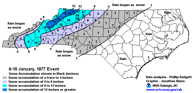
I do recall January '77 being a very snowy month. I was a freshman at Wake Forest. I think that was the only time in my four years there that classes were canceled. Maybe twice during the month? I had a suitemate from Haywood County (Canton, to be precise) whose younger sister did not attend school the entire month of January. I'll have to see if I can find NOAA records for that winter. -
2023-2024 Fall/Winter Mountain Thread
mercurydime replied to The Alchemist's topic in Southeastern States
1.04 here and currently 33.3. -
2023-2024 Fall/Winter Mountain Thread
mercurydime replied to The Alchemist's topic in Southeastern States
32.2/32 here just after 8a. .63 in the guage. Some icing. Just enough to make my 'indicator' jack pine droop from the top a bit. -
2023-2024 Fall/Winter Mountain Thread
mercurydime replied to The Alchemist's topic in Southeastern States
19 for me this morning. Just shy of 46 for the high today. -
2023-2024 Fall/Winter Mountain Thread
mercurydime replied to The Alchemist's topic in Southeastern States
I remain fascinated about the consistent temp difference between @wncsnowand me. We're only a very short distance apart, and I'm probably 300'+ in elevation difference. I've crept up to 35 in the last hour. He was at 29 when I was ~33. -
2023-2024 Fall/Winter Mountain Thread
mercurydime replied to The Alchemist's topic in Southeastern States
Currently 35.4/22.5 here in PG. -
2023-2024 Fall/Winter Mountain Thread
mercurydime replied to The Alchemist's topic in Southeastern States
Been a minute for me, too. I think it was during the Eastern days when I joined. I was still teaching then (gone now 13 years). I was (and remain) fascinated by the weather; especially winter weather. I was the "snow guy" at my high school. Not a better resource than this community to up your weather street cred. Appreciate y'all. -
2023-2024 Fall/Winter Mountain Thread
mercurydime replied to The Alchemist's topic in Southeastern States
I am fond of electricity. -
2023-2024 Fall/Winter Mountain Thread
mercurydime replied to The Alchemist's topic in Southeastern States
You'll have to squint. There wasn't much, for sure. Real light stuff blowing in on the wind. -
2023-2024 Fall/Winter Mountain Thread
mercurydime replied to The Alchemist's topic in Southeastern States
Flurries (very light) here in Pleasant Gardens...but at least there's some snow... -
2023-2024 Fall/Winter Mountain Thread
mercurydime replied to The Alchemist's topic in Southeastern States
10.16 for the month. That's a drought buster. -
2023-2024 Fall/Winter Mountain Thread
mercurydime replied to The Alchemist's topic in Southeastern States
4.96 here with 2.74 of that today. -
2023-2024 Fall/Winter Mountain Thread
mercurydime replied to The Alchemist's topic in Southeastern States
25.9 for my low...above you. When it's cold and windy, that's my least favorite combination. -
2023-2024 Fall/Winter Mountain Thread
mercurydime replied to The Alchemist's topic in Southeastern States
I do. I'm at like ~1650'. I've noticed you tend to run a little lower temp than I do fairly consistently. Not sure if my direct proximity to the escarpment has anything to do with it. Elevation doubles directly to my west in mile or so. -
2023-2024 Fall/Winter Mountain Thread
mercurydime replied to The Alchemist's topic in Southeastern States
19.3 to your NNW. Colder in Bostic than Pleasant Gardens. Micro climates are fascinating. BTW, Bostic's mayor and I, while not terribly close, have known each other since elementary school. -
2023-2024 Fall/Winter Mountain Thread
mercurydime replied to The Alchemist's topic in Southeastern States
3.23 inches of rain for the event here in Pleasant Gardens. Didn't see any flakes last night up to around midnight. We surely needed that rain. I'll stay tuned here for any positive changes in the snow forecast during the weeks ahead. 'Preciate y'all. -
2023-2024 Fall/Winter Mountain Thread
mercurydime replied to The Alchemist's topic in Southeastern States
From the latest news report I can find on the McDowell wild fires (WLOS): "Officials report as of Friday afternoon, the Locust Cove #2 Fire is 10% contained and the Clear Creek Fire is 0% contained." And: "A spokesperson with the U.S. Forest Service (USFS) says the Locust Cove #2 Fire is currently estimated at 150-200 acres, while the Clear Creek Fire is estimated at 124 acres, as of Friday." -
2023-2024 Fall/Winter Mountain Thread
mercurydime replied to The Alchemist's topic in Southeastern States
I have not heard/read a thing. They are basically separated by ridges. We know it wasn't lightning. I'm hoping arson isn't involved. Haven't caught up with it today, though. Surely this little bit of rain has helped. Only .11 here at the house, however. -
2023-2024 Fall/Winter Mountain Thread
mercurydime replied to The Alchemist's topic in Southeastern States
That Clear Creek fire is a little too close for comfort. -
2023 Mountains Spring/Summer Thread
mercurydime replied to Tyler Penland's topic in Southeastern States
9.22" for the week. -
2023 Mountains Spring/Summer Thread
mercurydime replied to Tyler Penland's topic in Southeastern States
Right where I am, the elevation doubles (from ~1700 to ~3400) within a mile or so west. That's bound to play into these comparatively exaggerated amounts of rain we get here sometimes.


