

pasnownut
-
Posts
9,519 -
Joined
-
Last visited
Content Type
Profiles
Blogs
Forums
American Weather
Media Demo
Store
Gallery
Posts posted by pasnownut
-
-
10 hours ago, Jns2183 said:
Here we go

Sent from my SM-G970U1 using Tapatalk
hoping it keeps heading west a bit more, before making the turn north. Should wring out much of the "extratropicalness" by the time it gets back to the east.
(my cool new word for the day)
-
 3
3
-
-
14 hours ago, Itstrainingtime said:
I'm approaching 25" since May 1st.
its just crazy. What a difference a year makes.
-
 1
1
-
-
18 hours ago, canderson said:
I had bad experiences with corrugated in Texas and got a bid for standing seam …. $44,000. Nah I’m good lol
Yeah standing seam is a tad bit rediculous. I got thicker guage corrugated and have been rather pleased. Good luck w/ your new roof.
-
1
-
-
2 hours ago, TimB said:
I was just trying to help him correct his data.
right or wrong, you troll him....and others, and its always a 1 -2 punch w/ you and your TC warmie pal. You guys sit in same chair?? asking for friends.
No matter....its old, and poor form.
-
31 minutes ago, canderson said:
I signed a contract for a new roof so it can stop raining for 3 o4 so weeks so it can get put on kthnx
Also anyone want to gift me cash? Ha!
just did mine 2 years ago, and we went w/ corrugated tin....
Yeah that check hurt to write. Hoping the extra jingles paid will be justified in long run. We do like the look.
-
in last 2 days I got .77 tues and .6ish last night
as others have stated (here in Lanco), its as lush as I've seen in some time for mid July. Nice to see the grass recovering from last couple years of dry periods that have wreaked havoc on my areas w/ shallow rock beds below.
Happy mid summer to all.
-
2
-
-
22 minutes ago, TheClimateChanger said:
What? It never gets above 90F on Mount Chesco!
Hey everyone......looky who stopped in...the wondertwins.
Now do the forum a favor.....and deactivate.
(many old timers will get this)
He offers far more credible info than you guys ever will.
-
22 minutes ago, Itstrainingtime said:
I have an appointment tomorrow with a lung specialist. A recent test showed something of concern (non-cancerous, they believe) so I'll have a better idea of what's happening soon. Current thought is that the chest infection that started all of this back in April might have caused permanent damage. Right now there's just too much unknown for me to really say more. I'll update when I'm able to.
Overall, I feel better than I have in years, ironically.
Keeping you in my thoughts n prayers for a good outcome. Health scares even without a diagnosis, can lead to healthier habits, or better self awareness, so that in itself is a good thing.
-
 1
1
-
-
1 minute ago, Itstrainingtime said:
I'm sitting at 30.88" YTD - you have; however, doubled my rainfall total since Saturday that really narrowed the gap. I really "cleaned up" during May.
Good to hear from you during your hibernation. A lot of us are certainly at the point of crying "uncle".
Of course, we'll probably flip a switch and enter a prolonged dry spell over the 2nd half of summer. It would be nice if we could ration all of this out, ya know?
Hangin in and hangin on....
The weather and cooko for cocco puff light and sound show last night, coupled w/ the monsoonal rains, scared my arse right outta my cave....so here i am.
hell...i'll say it.....UNCLE! What a diff a year makes. Not sure which evil is better, but like my wife always says, too much is better than not enough, so I'll go w/ that, and see how tonight goes.
Hope you are doing well/better.
and hope the rest of you blokes are well also.
-
2
-
1
-
-
2 minutes ago, Jns2183 said:
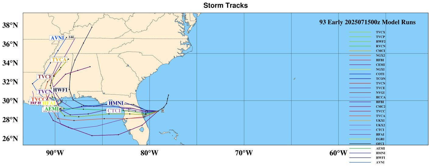
The NAM forecast soundings are not pretty
2:00 PM (Second Image)
Thermodynamics:
Moisture has deepened significantly through the low-mid troposphere.
CAPE increasing. Inversion breaking down.
CIN: Nearly eliminated.
Wind: Weak veering. Still light but flow is organizing.
Interpretation:
This is the convective initiation (CI) window.
Expect first storms around or after this point, especially if boundaries are present.
Tall, narrow CAPE profile supports efficient rainfall.
--- 5:00 PM (Third Image)
Thermodynamics:
CAPE is strong, with tall and narrow shape: classic flash flood profile.
Fully saturated up to ~500 mb.
Wind:
Still weak steering, slight veering.
Winds supportive of parallel cell orientation, a key factor in training/banding.
Interpretation:
This is the high risk time for backbuilding storms.
Low LCLs + tall moist layer = efficient rain production.
Very favorable for anchored convection with heavy rain.
--- 8:00 PM (Bottom Image)
Thermodynamics:
CAPE remains robust.
Deep warm-cloud layer (melting level) = high rainfall efficiency.
Winds:
Very weak aloft → poor storm motion → cells likely to stall.
Shear drops significantly.
Interpretation:
Flash flood risk peaks if convection sustains.
Weak outflow winds suggest training, merging cores, or cell regeneration.
Sent from my SM-G970U1 using Tapatalk
Nice work pal. Enjoyed the read. Thanks for the insight.
-
1
-
-
6 hours ago, pawatch said:
Hope everyone is safe and nobody gets flooded, These kind of storms are deceiving on the yearly totals. Mostly all run off
while thats often the case, we are waterlogged down here and runoff is largely cause soil cant hold anymore. NWS suggested that in their recent disco for today's possible "fun". I passed 3 stranded cars on way to work, and 2 were in pretty deep (etown rd and near my home in akron).
Good luck to all who got hammered yesterday and may get it again today. that graph above is ominous for us southers.
-
3
-
-
38 minutes ago, Mount Joy Snowman said:
Did you see this week's update where they basically removed everything?
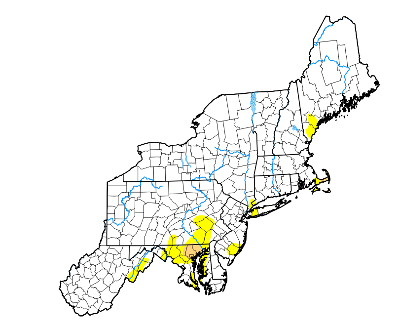
i did not, but when i read the 5/28?? update, a footnote suggested that more area were likely to be reduced moving forward. My question was that we already had most of the rain in the bucket, and wasnt sure why the 5/28 map wasnt reflective of that. Again, that's showing the limits of what I know about drought/precip maps and the criteria used to make em. Thats all. Regarless, the map you posted is a much better looking one. Hoping further reductions are warrented, and not further increases. Been there...did that.
Have a good one gang.
-
1
-
-
12 hours ago, Blizzard of 93 said:
Don’t let the warm trolls bother you.
We get 2 days of seasonal warmth & out they come.
At least we don’t need to suffer through all of the “Drought” maps anymore.
I looked at the drought map "update" last week and was surprised to see what i saw. While we've recieved a bunch, I'm wondering if lower level ground soil content is still lacking. Dunno, but that's the only solution my limited brain could muster up. No matter, still in a much better place than were we were.
-
2
-
-
11 hours ago, Blizzard of 93 said:
Thank you for this…
I am already done with Summer & we are just getting started.
We are getting a new HVAC system installed later next week. In the meantime, I am squeezing out what little chill is left in the old system, which isn’t much. I have it set at 72 & we have been hovering near 80 in the house today.
lol My old and underpowered system was not working last night. Gave the condenser a once over and i'm cool again. Needed a little more tlc than what I did in april. New condenser likely on the short list of "to do".
I just roll w/ the summer now. Used to despise it, but I've learned to take the best outta everything life gives me. Keeps me happier that way.
With that said, happy summer all.
-
6
-
-
18 hours ago, ChalkHillSnowNut said:
I’m pretty sure it’s the same dude with 2 accounts
said that for years. Cant imagine having enough time to post and counterpost my ramblings in support of myself.....

-
 1
1
-
1
-
-
14 minutes ago, Itstrainingtime said:
I was wondering where you were. Good to hear from you.
I browse every so often, but as stated a while back, thought it a good time to "get to work", as things were slow and in truth thought it a good time for a break in addtion to my usual sprint/summer board break.
I'll stop in ever so often. Sounds like your getting answers to your health riddles. Fingers crossed for you pal.
TTFN
-
1
-
1
-
-
56 minutes ago, mahantango#1 said:
That better than girls gone wild?
56 minutes ago, mahantango#1 said:That better than girls gone wild?
How bout girls doin weed, then goin wild?? J/K but i bet that would get some views.
Just havin fun and responding to comments, as like Chandler Bing...sometimes I just cant control myself from commenting, and for the record...this was no attack on any that identify as girls....or do weed. Just connecting dots.
Miss yas. Happy Spring.
Nut
-
1
-
2
-
 1
1
-
-
I miss snow already.
Got a feeling that I'll be cave dwelling this spring/summer. Warmth is more enjoyable than it used to be, but I find little joy in searching for it, as its always around the corner. I'll just be outside enjoying whatever comes my way. I hope everyone here can do the same. Good food for the soul.
Also as we've historically seen the 1 sided slander, and it's going to be hard to just "sit back" and take it (like many of us have over the years), so out of respect, I'll just step away as well. My work is surely suffering (and it was expected), so it's probably best that I type less and work more.
I just hope we can all agree that something needed done, and there were always going to be winners and losers no matter how it is done. I feel for those affected, and hope that as good ones are displaced, that the private sector snatches them up and their worth is realized. As I've helped to run a business, sat on a board of directors for 7 yrs., hired and fired, I now am a fully commission based employee. Every month my numbers (report) is shared with all senior management....and while I may be in the cave this spring/summer....I surely can't hide in there, as it wont feed me and mine. I can understand the gravity of making difficult decisions... I've made them, and saw how it affected people. It's never taken lightly.
Ground truth is that facts and feelings don't always jive when the word "work" is being discussed.
My best friend always says to our crew...especially the kids (mine included)...."they call it work for a reason....its your job". Timely and really resonates...
No matter where you sit, y'all are extended family to me, and welcome at my table.
TTFN
-
4
-
1
-
-
12 minutes ago, Itstrainingtime said:
DT calling people stupid...
Virginia had a snowstorm last week. Interestingly, I was following along in the Richmond-specific thread and the posters were sharing what the local forecasters were calling for...most were in the 3-6" ballpark for Richmond proper. DT was calling for 9-12" and was calling out the local forecasters for their "lack of understanding of what was about to happen."
Richmond's final official tally: 4"
Its a shame that his posting style is what it is....
I'll take 10 JB's over 1 DT. at least jb admits when he busts.
DT goes down scorched earth in a blaze if fire/smoke and just hammers peeps who call him out.
-
1
-
1
-
-
53 minutes ago, Mount Joy Snowman said:
Haha yes that's him. I remember that avatar as well. I don't recall getting any type of confirmation but I could be wrong. I think you mentioned something vaguely about him posting in some forums but not sure. In any case, I can finally let this rest ha.
All good man. All good.
If the pic shared is correct, I was wrong about his photo. Just remember darkish theme.
-
1
-
-
3 hours ago, Mount Joy Snowman said:
Yes, and I am still looking for someone to confirm the existence of a poster named UndertakersSon (went by UTS) from some far-flung weather board from many moons ago

Thought we covered that. Yes, you are correct. If memory serves his screen pic had some dark hooded grim reaperish kinda thing going on. I remember him.
-
6 minutes ago, sauss06 said:
we never met in person, but i am a excellent judge of character, my intuition has NEVER been wrong. You're a solid dude Mike!
whattdya think of me......???
Dont answer that.....
-
3
-
-
18 minutes ago, Itstrainingtime said:
Thank you. I went against what I always do when I'm around other people. I learned (very painfully) years ago that jokes tend to hurt others while humor is often self-inflicted. I have zero problems making fun of myself. None. In fact, I think that most who sit in my development classes respect me because of that. I like to make myself small in order to make others feel big. "A Day In The Life" is sort of a departure of that - although I typically make fun of myself as well.
25 was my morning low.
You and I are very similar. I make myself the "target" to make others feel at ease, as I'm a jokester and spare noone...me included. Some peeps struggle w/ the give an take of snyd comments, even when intended for fun. That's not your problem, but that IS how life goes.
I know it sucks, but you did nothing wrong, as you spread out the ribbin by including many in here. You know I was on his ignore list for many moons. I hope Bubbles can come around and realize that intentions here are not malicious. It was a funny read, and he's one of us.
BTW, if yall want todays temp rundown from city to stream, I'm happy to share
-
1
-
1
-
-
27 minutes ago, Mount Joy Snowman said:
Low of 26. Pretty nice week ahead. Seems likely we'll have some storm chances of varying type through mid-March.
Yeah it sure looks like there's still stuff coming at us. Just gotta hope for a couple more dips in the jet in the east with a well timed vort.
BTW 147 miles on sleds on Saturday. SOLID 6-7" otg at the cabin. Plow on UTV struggled to bust through. Its not going anywhere fast up there.
Hoping for 1 or 2 rides before we close the curtains on a much better year than expected.
-
3
-
1
-
Central PA Summer 2025
in Upstate New York/Pennsylvania
Posted
holy shnikeys....
now watch, it'll take you the rest of the year to get to normalish climbo.....
mo nature has ears and listens to us as big totals are boasted.