

CentralNC
-
Posts
532 -
Joined
-
Last visited
Content Type
Profiles
Blogs
Forums
American Weather
Media Demo
Store
Gallery
Posts posted by CentralNC
-
-
1 minute ago, Poimen said:
The NAM/RGEM concerns me for the NW Piedmont portion of this forecast. But we shall see:
No doubt. I just don't see how we don't have significant mixing during the height of the storm. Mainly IP of course.
-
 1
1
-
-
Just now, Poimen said:
Without soundings it's hard to know what's going on. Maybe it's an issue with the program indicating sleet when it's actually a snow sounding? I mean it was showing sleet on the maps even over the mountains and we know that's not the case. It still has 8-11" in our neck of the woods.
Yeah would view as outlier but is a head scratcher
-
1
-
-
5 minutes ago, Poimen said:
Should the RGEM concern us? It's basically a sleet storm for even the Triad. I seem to recall that it has performed well in the past.
Yes we know what the warm nose can do
-
 1
1
-
-
My son Tommy is checking out this thread...ready to rumble at WCU!
-
1
-
-
Latest Heavy Snow discussion. Sorry if already posted
https://www.wpc.ncep.noaa.gov/discussions/hpcdiscussions.php?disc=qpfhsd
-
2 minutes ago, Buddy1987 said:
I will say the 3k nam is not that far off from it, at least up this way. Never say never it’s nailed these things several times before.
Yes, silly of me. Just feels like a carolina special to me. Not totally off the table however.
-
1
-
-
8 minutes ago, Brick Tamland said:
I'll take any of the models. Most appear to have 6 to 12 inches of snow for me. Heck, I'd take about 4 inches of snow and some ice mixed in, too.
CMC is out to lunch. No way this storm goes that far north
-
1
-
-
5 minutes ago, HKY_WX said:
The models changes have been mostly noise at this point, from what I've seen. I'm going with the below:
Charlotte: 3 to 5inches of snow/sleet followed by .25 in freezing rain
Raleigh: 2 to 4 inches of snow/sleet followed by .5 in freezing rain
Boone: 1 to 2 feet of snow
Asheville: 8-12 inches snow/sleet
Greensboro: 6-10 inches snow/sleet with a light glaze of Freezing rain
The worst freezing rain will be on the transition line as always, which will run from south of Charlotte up to southern Wake County. Anyone on the 31-32 degree side of this line could see as much as an inch of freezing rain. I could see this happening in the zone from northern SC towards the Pinehurst area.
My main analog continues to be Dec 4&5th 2002. The only difference is the s/w appears to be a bit further south this go around, resulting in a bit more snow/sleet vs freezing rain. Still favoring a Miller A/B hybrid, which will result in a sleet changeover for many areas.
That is about what I was thinking as well. I don't see how the western piedmont escapes at least some ice but not as much as 12/2002 storm. Agree some are going to get killer ice storm just like 2002 storm. Probably south of that storm like you mentioned.
-
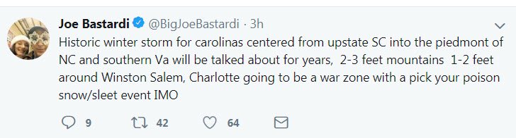
Even for Bastardi this is pretty strong
-
1
-
-
3 minutes ago, ILMRoss said:
Something I’d watch out for in this next suite is cyclogenesis along the Atlantic- so far not a single global has represented this well to my eye. The mesoscale models look more believable. Here’s what I mean:
Cyclogenesis is favored to occur in areas where there’s already a distinct low level vorticity axis (think: frontal boundary! “Low level vorticity axis” sounds like an intimidating weather term but it’s really just represents a wind shift!)
In CAD regimes, there’s always a super distinct axis just off the coast between the CAD Airmass and the coastal front. Thus, as that area has some lift imparted on it, you’d expect pressures to drop and cyclogenesis to initiate.
The globals don’t show this. Here’s the GFS: it has not signature along the Gulf Stream at all... and I’m not sure I buy that. Here is the nam in comparison at the same time:
In the nam, there’s a much more distinct signature of this taking affect, and this represents what “supposed” to occur in this scenario. I think this is helping toss everything more northward in the NAM.
Now, obviously, meteorology doesn’t always bend towards what’s “supposed” to happen, as any seasoned weather enthusiast knows. That being said, I wouldn’t be surprised to see a “CAM vs Global” battle emerge today as more CAMs get in range. Lastly- CAM = convection allowing model- think NAM, RGEM, HRRR, etc. They don’t have to parametize convection with their higher resolution.
.In his blog Crankywxguy talks about this being an elongated Low and less consolidated. Interesting. Thanks for the insights!
-
2 minutes ago, Jet Stream Rider said:
Impressive amount of moisture coming in off the Pacific into the southwest and feeding into our system as it begins to get organized. Once the vortex moves east and begins to tap the GoM, it looks to be substantial. The early finger is further east and south than I anticipated this morning.
Yeah I think there are going to be some hearts broken in the MA forum.
-
1
-
-
Just feels to me (maybe my old bones) that this is trending south for highest amounts for snow. The "finger" on radar seems more W-E instead of NE and it is below my latitude.
-
1
-
-
1 minute ago, ajr said:
I’ll feel better about this if the NAM keeps improving.. the sting of Jan 2017 is still there. I can’t think of a storm where cold overperfromed models in the RDU area..
January 2000?
-
1
-
-
5 minutes ago, Poimen said:
According to the NWS probabilities, roughly a 50% possibility of more than one foot in Forsyth.
Where are you seeing that. Looks like 10% on WPC winter weather product
-
GSP zones are out.
-
Just now, donsutherland1 said:
IMO, based on the forecast 500 mb pattern, its forecast evolution, and the very good run-to-run continuity of the guidance, one should have above average confidence in the modeled snows. While some changes from the current guidance are likely, those changes should be smaller than is typically the case. One isn't dealing with a storm in which there's a significant probability that it could track much farther north and west than what is currently shown. One also isn't dealing with a storm where there is such great uncertainty about the thermal profile or a marginal air mass where things could rapidly "fall apart" so to speak. This is likely to be a special storm for the Lower Mid-Atlantic and parts of the Southeast. It could be a memorable one for parts of the region.
thanks Don! you da man!
-
3
-
-
Just now, PackWxMan said:
GSP busting big on this one. CLT is not getting a foot. It’s Thursday and 12in on Sunday/Monday is being tossed around ?!?
Not sure I agree or not but this time GSP seems a little too overconfident and RAH underconfident.
-
2
-
-
Just now, North Balti Zen said:
Checking in from Baltimore, gave up on this up here 24 hours ago. I have in-laws in Brevard and a daughter in Greensboro, so will live it through them and you all. Good luck, the ensemble agreement for your area is a stunner. The big ones often lock in early, and it appears to have been that way for you guys. Hope you all get across the finish line with it.
Thanks! As you can tell, it's a nervous forum down here as we have had the rug pulled out from under us too many times!
-
2
-
-
Alright who's going to get dry-slotted?
-
1 minute ago, griteater said:
Out to 75 on the NAM, and there's another shortwave that dropped into the NE 50/50 low and there's more confluence now than the last run, so it looks like it will stay fairly suppressed
is this 12K NAM?
-
6 minutes ago, southernskimmer said:
Calling someone a tool is such a tool thing to do
Anything goes in the sanitarium!
-
Just now, PackGrad05 said:
I mentioned this earlier but it got swamped in the discussion. I think one of the reasons RAH isn't sold yet is surface temperatures. The surface temps just don't look that great during the event. There will be a lot of melting and cold rain. The cold temps really don't get entrenched until Monday night/Tuesday.
I agree with them in Triangle but not Forsyth and Guilford
-
3
-
-
2 minutes ago, kvegas-wx said:
Maybe a 3 way call with proper introductions? Do these guys even know each other? Maybe an annual holiday party or something? Good grief!
Seriously...hopefully the coordinate tomorrow. My money is on GSP!
-
1
-
-
Wow what a difference in AFD between RAH and GSP. Not unusual. RAH will play catch up like they always do.
December 8-10 Winter Storm Obs
in Southeastern States
Posted
Snow in Lewisville