
Interstate
-
Posts
5,731 -
Joined
-
Last visited
Content Type
Profiles
Blogs
Forums
American Weather
Media Demo
Store
Gallery
Everything posted by Interstate
-
Is this just for reporting stations or can you do it for any location?
-
Yep as it should be. That is the way the cold air will be coming in. it is all about how fast the cold air gets here.
-

January Medium/Long Range: A snowy January ahead?
Interstate replied to mappy's topic in Mid Atlantic
When was the last time we got a Miller A? -
I will be happy to have snow on the ground for 2+ straight weeks. When was the last time that happened?
-
Yeah but for most of us the spells doom. Another shift like that and we are blanked like the RGEM. Which was even worse.
-
Well the GFS just went way NW with the heavier snows. Relatively speaking. Cold air usually comes in slowed than model.
-
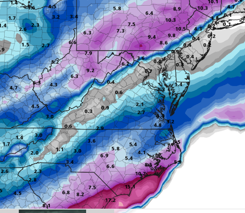
Model guidance appear to have delayed somewhat the advance of the Arctic air across the local area Sunday compared to recent days with the Canadian model being the slowest model. Anyhow, a second stronger area of low pressure will pass across southern VA Sunday afternoon with the ECMWF indicating the low pressure center passing across northern NC, GFS across southern VA, and Canadian model across central VA. This will bring moderate precip across the area Sunday, before exiting Sunday evening. Limitations for a big snow storm are fast movement of this system (i.e relatively short duration of precip 6-12 hours), and lack of a closed upper air system. However, it looks like there could be a 6-hr period, mainly 18Z Sun-00Z Mon where precip rates could be quite heavy. Winter Storm Watches were upgraded to Warnings where cold air will be locked in place, but expect additional Advisories to be issued later today or tonight further south where temps are more marginal/questionable. Precip will exit early Sunday evening with very cold air filtering in on brisk NW winds. Extreme Cold Watches remain in effect and may need to be extended south and east.
-
I doubt there will be. Most likely a WWA. I think getting 5 inches uniformity will be hard out of this one.
-
RGEM still says no and is even worse.
-
Watches and warnings don’t make it snow. I am under a warning my PAC is only got 2-4 inches.
-
Anyone see the moon around 9PM tonight. It was crazy big. I have never seen it look so big in my life. I wish I would have gotten a picture but I was driving.
-
Famous last words.
-
The CMC and RGEM have not moved for days
-
This is my fear. Models always over do the speed of cold air
-
You should be loving life with this run.
-
It is never good when you have a L over the Upper Chesapeake Bay
-
There should be no school anyways... MLK Day
-
Until it sails away to Pennsylvania. @North Balti Zen The offer still standing for a Air BnB in Southern MD
-
Who would you rather have Stafford or Hurts?
-
Now we have to wait until 3:30 ish for the next model run.
-
I liked it better when the EURO started at 1AM/1PM
-
CMC is pretty brutal.
-
I guess not. It is more north with Sunday and more south with Wednesday..lol
-
Scary here... Most of the time, it takes the cold longer to push in then modeled.
-
So the GFS nails us but pushes the late week storm way south. Maybe the CMC miss on Sunday, lets the EOW storm climb the coast.


