
Interstate
-
Posts
5,070 -
Joined
-
Last visited
Content Type
Profiles
Blogs
Forums
American Weather
Media Demo
Store
Gallery
Everything posted by Interstate
-
And to be honest... we really get no QPF from any of the waves.
-
Yeah hasn't VA Beach had two Blizzards since ours in 2016?
-
Well I guess right now... on to the 20th ish
-
Yep... That stupid GL Low... Always Debbie Downer
-
It finally stops snowing in SE VA at H114.
-
and southern VA keeps adding as the boundary just sits there
-
Junk
-
Yep... the shield is a little bigger... no real changes that I see
-
The MillerB jump screw zone is in full effect.
-
Good thing they canceled everything
-
You are already 0-1 with the ICON
-
If you like that show... You should watch Silo.
-
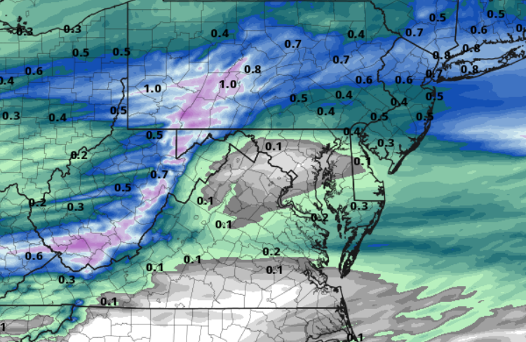
It looks like the Models are shifting all the heavier QPF is getting shifted north.
-
This is comical The 0z HRRR.
-
Yeah they have been playing lights out. Poole shot 16-32 for 50% and shot 4-17 from three point land. Maybe he should stop shooting 3s
-
I don’t believe so. Spacing is too far about.
-
You are welcome Wizards fans. Since I ragged on them, they have not lost. They just played the most amazing half of basketball.
-
This seems like a very quick mover... 6 Hours or less
-
3K NAM is pretty dry too ... spotty heavier areas of QPF
-
It does have one thing going against it... It coming in at midday though.
-
Yes I know I was a late on it... but no one actually posted the advisory other and a little screen shot on their phone.
-
WWA up for the Northern and Western counties URGENT - WINTER WEATHER MESSAGE National Weather Service Baltimore MD/Washington DC 935 AM EST Fri Feb 7 2025 MDZ005-006-503-505-507-VAZ506-526-072245- /O.NEW.KLWX.WW.Y.0007.250208T1700Z-250209T0500Z/ Carroll-Northern Baltimore-Northwest Montgomery-Northwest Howard- Northwest Harford-Eastern Loudoun-Northwest Prince William- 935 AM EST Fri Feb 7 2025 ...WINTER WEATHER ADVISORY IN EFFECT FROM NOON SATURDAY TO MIDNIGHT EST SATURDAY NIGHT... * WHAT...Mixed precipitation expected. Total snow and sleet accumulations up to one inch and ice accumulations around one tenth of an inch. * WHERE...Portions of central, north central, and northern Maryland and northern Virginia. * WHEN...From noon Saturday to midnight EST Saturday Night. * IMPACTS...Plan on slippery road conditions. * ADDITIONAL DETAILS...Precipitation is expected to overspread the area around noon on Saturday. Precipitation likely starts as snow before transitioning to sleet and eventually freezing rain through the afternoon. Precipitation will transition to rain late Saturday evening as temperatures warm.
-
Yep... It hits a wall right at the county line
-
It looks stronger on the H5 at 90
-
The heights are slightly lower on H81 H5 maps


