

Interstate
-
Posts
5,726 -
Joined
-
Last visited
Content Type
Profiles
Blogs
Forums
American Weather
Media Demo
Store
Gallery
Everything posted by Interstate
-
I was looking at H5@39... so you are ahead of me... maybe something switches in 3 hours... and it does
-
Yeah that looks more positivity tilted than the 12Z
-

The February 22-23 Late Season Miracle: JV Disco/Banter Thread
Interstate replied to bncho's topic in Mid Atlantic
46.4/46.1... This is why I have a WSW and you dont. -
URGENT - WINTER WEATHER MESSAGE National Weather Service Baltimore MD/Washington DC 231 PM EST Fri Feb 20 2026 MDZ004>006-008-011-503-505-507-508-VAZ505-210345- /O.EXB.KLWX.WS.A.0003.260222T2000Z-260223T1500Z/ Frederick MD-Carroll-Northern Baltimore-Cecil-Southern Baltimore- Northwest Montgomery-Northwest Howard-Northwest Harford-Southeast Harford-Western Loudoun- 231 PM EST Fri Feb 20 2026 ...WINTER STORM WATCH IN EFFECT FROM SUNDAY AFTERNOON THROUGH MONDAY MORNING... * WHAT...Heavy snow possible. Total snow accumulations 5 inches or more are possible. * WHERE...Portions of central, northeast, and northern Maryland and northern Virginia. * WHEN...From Sunday afternoon through Monday morning. Snow may begin Sunday morning, but the heaviest snow and coldest temperatures are most likely late Sunday afternoon through early Monday morning. * IMPACTS...Travel could be very difficult, especially Sunday night into Monday morning. The hazardous conditions could impact the Monday morning commute. PRECAUTIONARY/PREPAREDNESS ACTIONS...
-
Feb 22nd/23rd "There's no way..." Storm Thread
Interstate replied to Maestrobjwa's topic in Mid Atlantic
All I am concerned with is where the SW in located and where it goes negative (if it does) -
Thank you Mods for everything you do and everything you have to put up with.
-
Feb 22nd/23rd "There's no way..." Storm Thread
Interstate replied to Maestrobjwa's topic in Mid Atlantic
They do... It is the Kuchera ratio -
Feb 22nd/23rd "There's no way..." Storm Thread
Interstate replied to Maestrobjwa's topic in Mid Atlantic
It is not the surface I am worried about. -
Feb 22nd/23rd "There's no way..." Storm Thread
Interstate replied to Maestrobjwa's topic in Mid Atlantic
it is way positive at 48 compared to 54@6Z -
Feb 22nd/23rd "There's no way..." Storm Thread
Interstate replied to Maestrobjwa's topic in Mid Atlantic
it is all about it going negative tilt now -
Feb 22nd/23rd "There's no way..." Storm Thread
Interstate replied to Maestrobjwa's topic in Mid Atlantic
I don't think I am liking the change... I could be wrong -
Feb 22nd/23rd "There's no way..." Storm Thread
Interstate replied to Maestrobjwa's topic in Mid Atlantic
The ICON is too late with the negative tilt -
Feb 22nd/23rd "There's no way..." Storm Thread
Interstate replied to Maestrobjwa's topic in Mid Atlantic
and as for the 3K... the meat of the storm is after the end of it run -
Feb 22nd/23rd "There's no way..." Storm Thread
Interstate replied to Maestrobjwa's topic in Mid Atlantic
THIS IS OUR STORM!!! -
Feb 22nd/23rd "There's no way..." Storm Thread
Interstate replied to Maestrobjwa's topic in Mid Atlantic
I do not know how it is a step back for Baltimore north. -
Feb 22nd/23rd "There's no way..." Storm Thread
Interstate replied to Maestrobjwa's topic in Mid Atlantic
Yeah... just need it to go negative a couple hours earlier -
Feb 22nd/23rd "There's no way..." Storm Thread
Interstate replied to Maestrobjwa's topic in Mid Atlantic
Looks better to me on the H5@18 -
Feb 22nd/23rd "There's no way..." Storm Thread
Interstate replied to Maestrobjwa's topic in Mid Atlantic
The NAM at H5@15 is more robust out west -
Feb 22nd/23rd "There's no way..." Storm Thread
Interstate replied to Maestrobjwa's topic in Mid Atlantic
I think someone needs a timeout
-
Feb 22nd/23rd "There's no way..." Storm Thread
Interstate replied to Maestrobjwa's topic in Mid Atlantic
Give me one good thing you have brought to the forum... other than the increased whining... have you bought any good analysis? -
Feb 22nd/23rd "There's no way..." Storm Thread
Interstate replied to Maestrobjwa's topic in Mid Atlantic
Yea. I don’t why people need to be negative. If they don’t think it is not going to happen then why be here. Just to say you were right? -
Feb 22nd/23rd "There's no way..." Storm Thread
Interstate replied to Maestrobjwa's topic in Mid Atlantic
I found his updated NWS forecast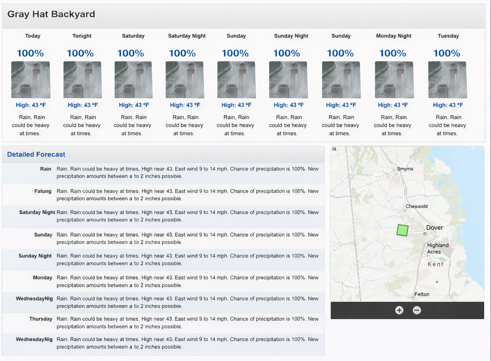
-
Feb 22nd/23rd "There's no way..." Storm Thread
Interstate replied to Maestrobjwa's topic in Mid Atlantic
I see Gray Hat is in a trolling mood like usual. -
Feb 22nd/23rd "There's no way..." Storm Thread
Interstate replied to Maestrobjwa's topic in Mid Atlantic
We are bring this one home!!! -
Feb 22nd/23rd "There's no way..." Storm Thread
Interstate replied to Maestrobjwa's topic in Mid Atlantic
Reminds me of Storm 2 in 2010


