tavwtby
-
Posts
2,814 -
Joined
-
Last visited
Content Type
Profiles
Blogs
Forums
American Weather
Media Demo
Store
Gallery
Everything posted by tavwtby
-
my bad thought it was 2001 not 2021... anyway think I'm wrong anyway, think it was the 2003 event
-
this blows for me, was expecting critical parts for my test overnight priority shipping and they delayed because of ice in Memphis and Dallas because of this, my test here is cursed I swear... now I have to wait for the weather to clear, FedEx says delayed beyond our control, how lovely
-
remember thunder snow with that one I believe, if I remember correctly, that was on a weekend no? or am I thinking of a different event? anyway it's been 80-86 here in Soflo, way above normal for even here, napes tan already and it's 2/1, gonna thin the blood, been gone most of the winter this year, enjoy the artic two days up there while it's 90 here Fri!
-
well happy birthday, and I'm still in Soflo so it'll probably snow, seems to be the theme this winter, I'm gone and there's winter at home...have to coach my son how to take care of the chickens when it gets ill cold later this week...he knows tho, animals can get wet, and can get cold, but can't get cold and wet, that's a death sentence... meanwhile it's mid 80s, and by weeks end be close to 90 here, even locals and snowbirds are saying it's warmer than usual this time of year here, so take that for what it's worth...
-
yeah mega piles, i have a pic my wife just pulled up from our first winter in Winsted where we had a pile where our driveway 90s, where most of the snow gets blown and I was standing in front of it and it dwarfed me, and I'm 6-1, easy a 7' pile of yore, ones we used to tunnel into for snowforts as kids, I'll try an upload it
-
73.3125 Average 30's 89.06363636 Average 40's 105.4454545 Average 50's 118.45 Average 60's 106.4 Average 70's 83.14 Average 80's 78.45 Average 90's 68.73 Average 00's 72 Average 10's based on official data from here back to the 30s, I'm not at my laptop but prior to this data back to 1887, was pretty low too, comparable to the 90s avg
-
15-16 takes the cake as ratters for mby at 27.5", 06-07, 18-19, &19-20 were all under 50" here, and from all the data I collected from this area, and thanks Will for the help acquiring more data, the avg here is 78" give or take...my average since moving here in 2013 is 74, but that's been going downward since 14-15... I'm at just over 10" season to date, so need a really strong finish to get to close to climo, don't see that happening with 1-3" events sprinkling in between raining cutters or fish food... fortunately I'm on my way south now so you'll probably get a KU as I'm gone.
-
the more things change.... just one of those winters, maybe we get lucky and pull out a HECS to just satisfy all, iirc, 92-93 wasn't a great winter but then we got March storm of the century, I could be wrong (Will what's your memory serve here), but then again I believe we did have cold around that season...at this point I'd be happy with just a monster, and it can stay normal or AN temps before and after, helps with the every increasing heating bills. Best shot looks early Feb then back to what we've been seeing this winter
-
anyone get close to warning criteria in the region? imagine up north got all snow outta this, nice week they're having, well needed
-
picked up 1.25" in that band that pushed through earlier, had a brief pelt fest, now sitting at 31/30 with zr drizzle...
-
maybe I spoke to soon, it's like a wall of white out there just smashed into my area and now I have to drive to Danbury
-
what an absolute fail by districts letting kids out early, nary a flake in some parts, had a quick shower of sugar up by Westfield earlier, now home with dim sun, perhaps by the time school let's out there will be a flake...man, hate to sound like a boomer, but we used to walk to school both ways uphill, while it was snowing and plows were going by...btw, it was literally uphill both ways, hill in the middle, and it was .8 miles from my house to school, now I think under.2 miles they have to bus
-
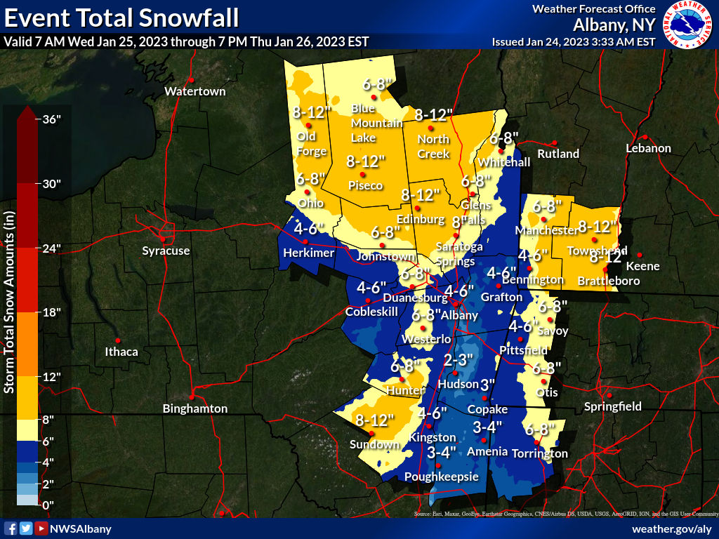
ALY came way down with the numbers more in line with what was expected, still thinking this may be a bit high
.thumb.jpg.2ecff3dd371af4ea3b0f16e2c524784a.jpg)
-
funny how they are all over the place with totals, I thought a few years ago the three offices that service SNE were going to put out one map? nevertheless, I'd lean more towards that BOX map than the ALY one having me with warning criteria snow, even though they have a watch 8 miles from my house, thought at least a wwa would be hoisted for tomorrow, still hoping be think we're just a little south for this one too

-
tried to DM you but didn't work, so 1.9" total including last night here in Winsted, 10.6" on the season...16.1" shy of the all time low ratter a few years ago.
-
similar streak to what we saw today, SLP is off, H7 and H85 lows are north of where SNE wants
-
I'll take that, honestly I'll take anything over 3", my threshold for using the blower or shoveling... I really wanna use this thing before I leave for like the month of February... but I have a feeling we're going to be just too warm and south for the goods, we'll see
-
 just Currier and Ives scene out there and grass cancel... happy for those who were in the goods, saving some from the basement and sad for others who still have yet to break anything... perhaps we'll get a surprise this year and get a region wide event that buries all, but I'll take my whitening and be happy heading back to Florida Fri so, may be the last I see for some time
 -
just about done here, 1.25" on the board, most of that fell in about a half hour where it was ripping intense, add that to the .6 I got before flipping last night and we almost made 2", this year I'll take. Still not enough to pull out the new blower, it needs to do some work. probably should be in the other thread, but how does this one, with the redevelopment interact with the midweek system?
-
yeah I'm feeling the same, finally going to beat the band here and back edge approaching... hopefully as Will said it continues to fill in but I'm thinking another hour and we're back to drip drip...
-
absolutely ripping aggies for a bit, vis was in feet, has eased up some but still solid snow, good growth, now accumulation on all surfaces, despite being still at 33/29...
-
flipped over slowly here starting around 1030, has had a hard time accumulating but rates and growth have been getting increasingly better, unfortunately I don't think time is on my side in trying to pull out a couple inches here, back edge approaching
-
picked up a little more than .5" last night before it flipped, now it seems I'm right on the edge of the goods as they pivot SE, hoping to grab at least a couple inches as this wraps up, need to really rip tho, as it appears the column is at 33...
-
I'm shocked it's still snowing pretty decent, small flake size but a solid 1/4" on all surfaces now, thought we'd be rain by now
-
32/27 and SN- atm...


.jpg.8d3178786e2e287df45a4c3b4963214b.jpg)