tamarack
-
Posts
16,500 -
Joined
-
Last visited
Content Type
Profiles
Blogs
Forums
American Weather
Media Demo
Store
Gallery
Everything posted by tamarack
-
Exactly the same here, 0.40" thru 7 AM and 0.78" 7 AM thru 9 PM. (Another 0.01" of DZ overnight, but that goes in the May bucket.) Month finished at 4.00" - 7th consecutive BN month and 10th of 11, but only by a whisker. April average is 4.06".
-
In Maine we call those tiny screen-penetrators mingies. In local French it's 'bruleau' - 'burning'. One rarely feels single bites, but hundreds of teeny-tiny attacks earn that description.
-
March here was +1.8. April will finish at +1.1. Since 1999, April has averaged 44% of available sunshine. April 2026 will have exactly the same. Precip will finish about 1/2" BN - we're at 0.5"-0.6" from the current event and the best is past. Yesterday's forecast of 1-2" for today was optimistic. Month is finishing close to normal.
-
Why do I hate ticks? One mid-range (pinhead size) deer tick latched onto my right lower eyelid last evening, within 1/16" of the top edge. After numerous tries I extracted the little horror, but the eyelid is nicely puffed up. The bit of pain with each blink reminds me just how much I despise the critters.
-
Heading into our 29th summer here, all the hail that has landed in our yard (only 2,000 sq.ft., but still) wouldn't fill a one-gallon bucket. One storm might've dropped a flattened chunk 5/8" on its longest surface. (On August 30, 2007, nickels/quarters hail 6-8 miles southeast from from our place accumulated up to 4" and fully defoliated/partially debarked trees on about 2,000 acres, so that kind of excitement isn't impossible here.) Low 60s for the high here, about 10° above the forecast. 3 hours of midday PC did its work.
-
Since you noted the errors first (a triple play), I'm responding your way. Average: 88.4" 2025-26: 86.8" Deficit: 1.6"
-
Sunny 60s here with the trout lilies beginning to bloom. Snow total for 25-26 (barring something very unusual) is 6.8". That's 1.8" BN, currently the closest to my average in 28 snow seasons, with only 2012-13 (90.4", 2.0" AN) being close.
-
72/30 yesterday, back down to 30 this morning and cloudless. The best of mid-spring.
-
Sliced and diced from your post. (And I appreciate the info on climate and forecasting.) A friend was a train fan - I think there's a mag by that name - and he had multiple albums filled with various engines doing various things. Once he was a bit to close after a big snowfall and got sluiced as the plow-fronted engine roared by. When I was 5, I was headed toward train-fandom. I knew more about trains back then than now, 75 years later. Temp over 70 after a low of 30; another '40' diurnal. Cut/split some firewood and worked up a good sweat.
-
If there's more sun than cloud in late April, the max will probably be AN at least 90% of the time. Last 2 days' max here averaged 61, which is 4° AN. The minima averaged 26, or 6° BN. The sun is mid-August strong.
-
Sandy River median is 2,990 cfs, record minimum 819, current 1,050. Bring it on.
-
Pawpaws at our frost pocket would probably fare the same as Reliant peach, which was (almost) a total failure. Hit 17° this morning, cool for late April, though we've matched it on 4/29 (twice).
-
First I've read of green ash surviving. Many sources have confirmed some survival of white ash but things look grim for green and brown. In Maine (also probably elsewhere), efforts are being made to collect brown ash seeds, to fend off extirpation of this species of great importance to indigenous peoples in the Northeast. (Other than urban plantings, Maine has very few green ash.) No sign of EAB on our woodlot but it's not far away. White ash is the 3rd most abundant there, trailing only red maple and balsam fir, and brown ash is a significant component as well. I plan to have a harvest in the next few years, and would harvest all ash of sawlog/veneer quality 14"+ diameter while retaining all other ash. (The 2013 harvest included no hardwood sawlogs but took a significant volume of hardwood pulp. A second harvest would take some red and sugar maple logs along with the ash.)
-
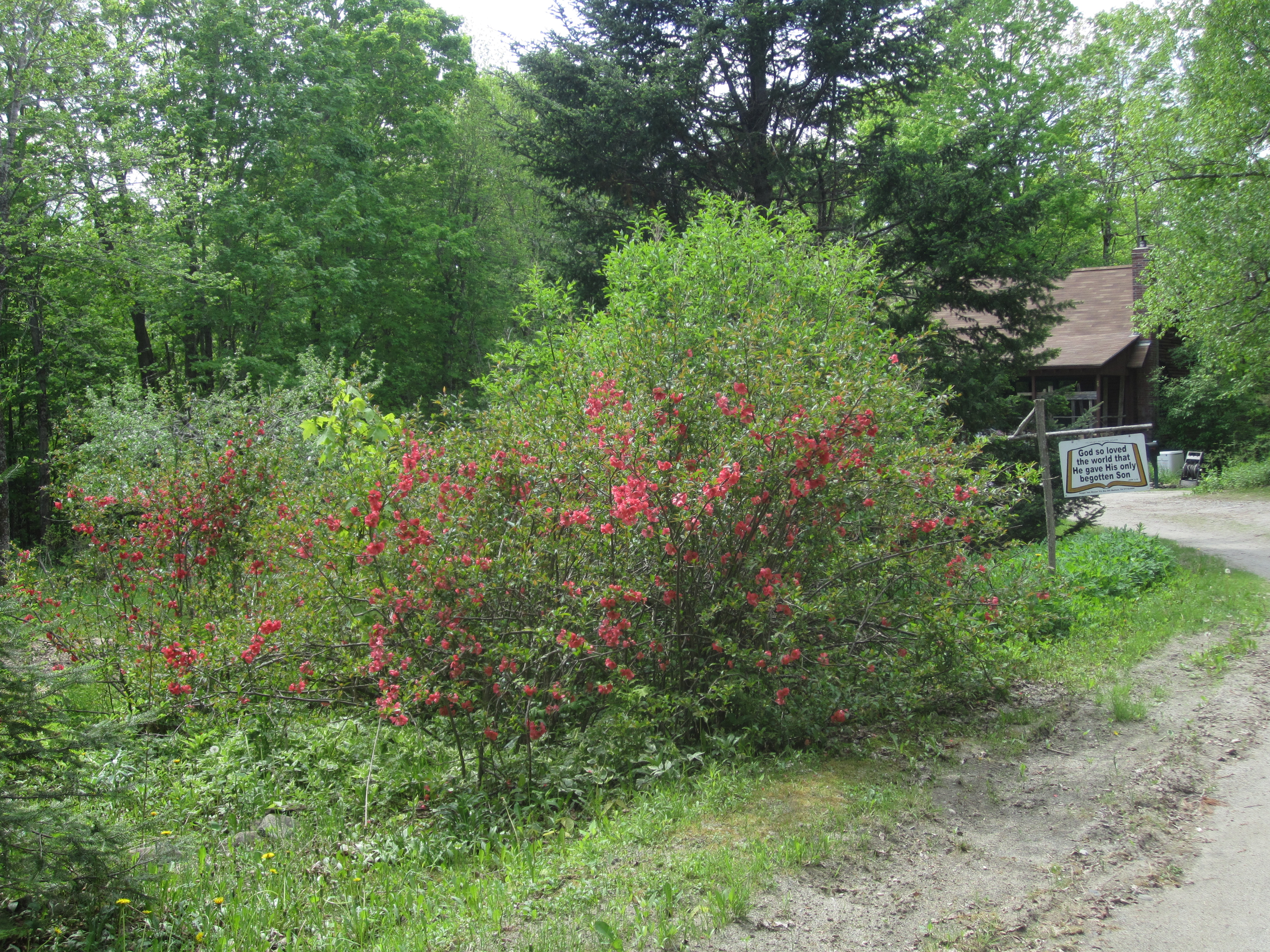
I guess that means I'm not one of "those that live in the woods". (Pic from late May 2024, quince blossoms, apple blossoms in background).

-
Any ash trees still alive there? they're one of the latest to break bud. Only black locust might be later. Still stick season here, though some tiny sugar maple seedings have a bit of green, thanks to the sun warming the leaf litter. Had a pretty flurry 10:10-25 this AM, briefly whitened the lawn during 2 minutes of heavier snow but just a trace.
-
Grandkids in Gloucester County enjoyed the heat. We managed to reach 70 last Tuesday. Then yesterday brought cold rain (0.66") that ended with a coating of snow, and 24° this morning.
-
48 years ago, the opposite occurred in Maine. On May 29, 1978, Eastport touched 70 then the onshore breeze and fog dropped the temp to 49 at mid-afternoon. Same time, HUL read 96. Yesterday the sun at least tried soon after lunchtime. No tries today.
-
April here has never been early enough to threaten late frost damage, but May is different, especially in 2010. That year had 3 straight months, Feb, Mar, and Apr, as our warmest, then May 1-5 was +14 with average highs of 77. Everything was 3-4 weeks ahead of average, then May 11-13 had minima of 22/26/25. 100% kill of apple blossoms and ash shoots, serious damage to maples, beech, birch, lighter damage to oak.
-
Barely managed to carry pack into April, only to 4/1. Average here is April 6 and it's ranged from March 13 (05-06, only 7.8" after Jan 1) to April 24 (00-01, 55.5" in March, 48" pack on 3/31). Average days with 1"+ is 123, and for consecutive, 116. Range is 81 days in 15-16 to 163 in 18-19, consecutive 73 (11-12) and 162 (also 18-19). Earliest start of consecutive pack was Nov 10, 2018 and latest Jan 4, 2000.
-
We bought one 6-7 years back, specifically for A/C - the only usable wall space was 10 feet from the Jotul. $3,500 installed and with the $1,000 rebate and the $500 tax reduction, the cost was quite reasonable. Very nice to come inside on a hot day, after garden work or playing with firewood, to turn the machine on high and bask in the living room.
-
Only 0.16" from this event, and the 0.03" overnight makes it 11 days with rain this month, with a grand total of 1.39". April average is a bit over 4" so the deficit continues to grow. Farmers were able to disk the fields along Route 2 last week, by far the earliest I've seen that. Low water table.
-
More signs of spring here - peepers, loads of wood frogs, pulled off tick #1. It chose to attach right over my sternum so easily detected. Dumped a medium white ash, 11" diam., 50+ feet, for the May mank. That's undoubtedly where the horrible little arthropod was hiding. Temp got near 70 with enough TD to bring some sweat from cutting/splitting.
-
Average precip here for those 16 days is 2.2". Would be nice to reach the average at least as we've been running at 60% since last June, though it would probably need 10-12 days with rain to get there.
-
2010 had our warmest April (of 28), also the warmest Feb, March and July. Earliest leaf-out I've seen here, unfortunately followed May 11-13 with mornings of 23-26°, killing off lots of the tender new foliage (and all our apple blossoms). Easter 1976 is well remembered, as we drove from mid-90s NNJ to stay with family (bro-in-law & wife) overnight in mid-90s Boston. Our 1971 Beetle's engine would be pinging with heat whenever we stopped. At their apartment entry, a rat ran across in front of us, too fat to get into the hole so it had to run around into the alley. Next day we drove home to Fort Kent, where it was only 60 (we loved it) and the snow hadn't finished melting. Then 2002 duplicated 1976 with mid-month heat, though not as widespread. Next sign of spring here: Wood frogs were quacking in the old stock pond. Peepers should open up by Tuesday.
-
Growing up in NNJ I saw exactly one tick, probably in 1971, definitely a dog tick. Began seeing dog ticks in Maine mid-1990s; one western Maine excursion (Lovell, Denmark) in June 1996 I picked 24 off my clothes/skin and brushed a dozen-plus from the pants - 100% dog ticks. Deer ticks began appearing about 10 years later, and my personal "best" is 26 on a state lot near Merrymeeting Bay in Topsham, late October 2019, 100% deer ticks. I was flipping ticks out the window onto I-295 going back to AUG, found the final 3 (tiny nymphs) at home that evening. Haven't seen any yet this year but will likely bag a couple the next time I walk thru our woodlot. I pick them up mostly May-June and Oct-Nov. For reasons unknown to me, the horrible little beasts seem to disappear in late summer here. In mid-August of 2019, our annual two-day peer-review field trip had 40+ attendees visiting Newcastle, Swan Island (huge deer herd there), Hebron and Skowhegan. Not a single tick was reported.