

Shack
-
Posts
287 -
Joined
-
Last visited
Content Type
Profiles
Blogs
Forums
American Weather
Media Demo
Store
Gallery
Posts posted by Shack
-
-
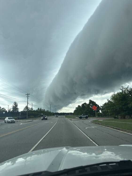
Nephew sent this from Newnan, Georgia this morning:
-
 7
7
-
-
On 4/27/2025 at 3:59 PM, GaWx said:
Tony,
-After a cold winter, March was mild and all but one day Mar 24th through April 4th had 80s! The consistent BN chill didn’t restart til 4/17. From then through August, most dailies were BN! Mid May had a 3 day period with lows in the 40s.
-1909-10 was the middle of a 3 year long La Niña. After that 3 year period came 1911-12, a moderate El Niño with several significant wintry precip events and a cold JF.
-Sunspots: 1909-10 was coming off the 1906-7 peak of the prior cycle, which was one of the two weakest cycles since after the early 1800s Dalton Minimum. The next cycle that was about as weak wasn’t until the one with the very weak min in 2008-9!
-Other Atlanta April measurable snows were 0.6” (4/4-5/1891), 0.2” (4/11/1918), and 1987 (4/3)(measurable northside but only T at KATL).
I remember the 1987 event. (if you can call it that)
Tony, I was working at the Experiment Station in Griffin. (Agronomy Department)
I have always held that moment in my memory of walking outside of the lab and seeing flurries and thinking, "Dang. April???"
-
3
-
-
Tornado Warning for west central Georgia:
The National Weather Service in Peachtree City has issued a * Tornado Warning for... Northeastern Muscogee County in west central Georgia... Southwestern Talbot County in west central Georgia... Southeastern Harris County in west central Georgia... * Until 445 PM EDT. * At 357 PM EDT, a severe thunderstorm capable of producing a tornado was located over Midland, or 10 miles northeast of Columbus, moving northeast at 40 mph. HAZARD...Tornado. SOURCE...Radar indicated rotation. IMPACT...Flying debris will be dangerous to those caught without shelter. Mobile homes will be damaged or destroyed. Damage to roofs, windows, and vehicles will occur. Tree damage is likely. * Locations impacted include... Ellerslie, Flat Rock, Junction City, Midland, Baldwinville, Baughville, Upatoi, Olive Branch, Talbotton, Po Biddy Crossroads, Geneva, and Waverly Hall.-
 1
1
-
-
NWS dropped
19 minutes ago, Shack said:First flash of lighting here was at 1:58am. I had my clock set to get up at 2:00 to do storm-watch duty for the household.
Go figure.
70/62
Watching that booger that just crossed the Alabama/GA line track pretty dang much in a straight line to MCN.
Pretty good hail sig in that line tracking through Talbot and Upson county.
Dogs piled around my feet.
NWS dropped the tornado warning for that one.
Dogs don't care.
Still piled around my feet.
-
1
-
-
First flash of lighting here was at 1:58am. I had my clock set to get up at 2:00 to do storm-watch duty for the household.
Go figure.
70/62
Watching that booger that just crossed the Alabama/GA line track pretty dang much in a straight line to MCN.
Pretty good hail sig in that line tracking through Talbot and Upson county.
Dogs piled around my feet.
-
1
-
-
Euro, says....no. (for now)
-
GFS says yes, .....
-
Reporting from St. Louis. 34deg and .....
I'm one mile from KSUS, Spirit of St. Louis airport in Chesterfield at my daughter's house.
For the first time in my life, THUNDERSLEET !
Walked the dog outside as it was very lightly sprinkling rain, could see lightning and hearing occasional thunder and then "Bam!" and the lightning shook the ground. I was startled but, almost like it shook the sleet from the clouds, the sound of "shlllllleeeeettt" hitting the ground like it had been dropped from a bomb bay stopped me in my tracks. Only lasted for about 20 seconds but, wow.
Too cool.
And, yes, the dog was more than ready to go back inside, looking at me like, "What the heck are you looking at and smiling ??!!"
-
2
-
-
1 hour ago, GaWx said:
This was a very enjoyable and interesting winter storm of rare proportions here! I measured ~2.9” (mainly sleet…see image below) from a 12 hour long combo starting as sleet for couple of hours, ZR adding to base for a couple more hours, back to sleet (much more that lasted several hours), and then some snow during last few hours often mixed with sleet. And it is a very solid 2.9”! Temperatures during the bulk of it were in the upper 20s.
That’s the most accumulation in this area since 12/1989. 1/2018 was ~2” of a combo.
I estimate the sleet portion of the 2.9” was 2”, which would almost have to be the most sleet in the city from any storm in modern records (back to mid 1870s). 1/2018 had a good bit of sleet that lasted ~2 hours (including when mixed with snow), but it didn’t get over 0.5”. This was the 3rd most sleet I’ve ever seen behind only two ATL sleetstorms (2/1979, 1/1988).
The ZR portion fortunately was much lower here than the ~0.45” in 1/2018. I’m guessing it was ~0.1” with no more than 0.05” of accretion. Thus, there were very few outages in SAV (only ~200). However, Glynn county (Brunswick) has a whopping ~28K outages, which is ~55%! Nearby Charlton county had a similar % out while Camden (~1/3) and McIntosh (~1/4) had fewer but still many out. So, extreme SE GA had by far the most ZR in the state, which was modeled well. I haven’t seen amounts yet.
Total liquid equivalent precip was 0.71” at more inland SAV. Based on models calling for an avg of ~0.10” more in my area, I’m guessing ~0.80” for my place, which would be near the similarly impressive ~0.75” I got in 1/2018 (that one lasted ~7 hours). Had all of the precip been snow (which was not forecasted), perhaps I could have had up to 5” based on rough Kuchera type of considerations (nowhere near 10:1 with 850s borderline). Regardless, this 2.9” of a solid layer, if anything, will very likely melt more slowly than 5” of pure snow.
After a low near 27, current temp has struggled to only 33. Thus melting of this rock solid accumulation has been very slow.

Edit: For me this was not only the Brick storm (thanks @Brick Tamland) but also the Tony @dsaurstorm due to sleet dominating! He would have loved it!
Edit #2: I brought inside 2 samples of the frozen precip that I had collected in 2 cylindrical cups to melt it and allow for an estimate of liquid equivalent. I did something similar in Jan of 2018 to estimate it for that winter storm. I plan to post about the results after this is completed. I’m roughly estimating 0.80” based on adding ~0.10” to KSAV’s 0.71”.
Many thanks for the stat's that you provided in the long range thread leading up to this. It's been a great few past days to speculate and then watch it all play out. Topped out at 2.1" here.
-
5
-
 1
1
-
-
If you want some fun later this week, just go back to the long range thread, page 40 or so, I think, and start reading the beginning comments on what has become The Brick Storm.
-
1
-
-
1 minute ago, NGTim said:
@Shack i think you are somewhat near my old stomping grounds (grew up in Fort Valley). I don't even regret missing out on this one here in N GA. I remember all those years down in Peach county watching the 6 o'clock news and seeing the snow line at Atlanta and above So I am enjoying this one as much or more than if it was happening in my backyard, because i know what its like when the only excitement for years is when they put 20% chance of snow in the extended forecast. Hope the storm overperforms down there big time. I'll never forget 1973 when i was in second grade. that started a life long love of snow. watching the 13 wmaz livestream its bringing back memories. can't believe Frank Malloy is still there. He's got to be 90, but doesn't look a year past 50. Or maybe my sense of time has gone bad. anyway, I'm just shouting out to the S. Ga folks i couldn't be happier!
Glad to hear you escaped ! I have good friends from Peach County. I was around for Feb '73. Thomaston area, then. Second grade, too. Got almost two feet !
Still steady light snow but only about an inch here, thus far. Hoping that those heavier returns in Alabama make it here. (And Frank Malloy has obviously been drinking the same water as Dick Clark, Tom Cruise, etc)
-
1
-
-
I would call it moderate snow here in Lizella(Macon). Started promptly at 2:00. Cars nicely covered. Yard about 50% covered. 30/21
-
3
-
-
6 minutes ago, BooneWX said:
Mping begs to differ on this being virga
Good to hear. Was really curious about the Arkansas/ North Louisiana returns. I was hoping that moisture transport was more north and maybe a little stronger than modeled.
-
1
-
-
Widespread, but light, Virga Snow (I'm supposing) to our west on radar right now. I looked around and don't see any reporting stations reporting that this is making it to the ground, but this radar image wasn't progged on any of the Hi-res models for this time period, was it? Or, can someone chime in that knows if the models account for virga in their renderings.
-
1
-
-
-
Metal Man and GaWx still looking good.

-
6
-
 1
1
-
-
Euro looks wetter than GFS and NAM at 81hrs to me...

-
3
-
-
"One of these things is not like the other ! "
-
2
-
 2
2
-
-
35deg and Light to moderate sleet now. Love the sound of it hitting the super-dry leaves in the yard.
-
3
-
-
20 minutes ago, dsaur said:
I've seen everything but hail in the last 15 minutes, lol, but it's pretty good snow right now. Probably a half inch on the ground and half that's sleet.
Great band that is delivering for the south metro, Tony ! 35/29 here and approximately 13 sleet pellets on the porch. (edit,..14 sleet pellets)
-
46 minutes ago, GaWx said:
Is anyone else bothered by this thickness/precip type 12Z GFS map? Typically in the SE the snow line is near 546-7. But this shows snow with thicknesses well over 552! How can this be? This is so odd! Can anyone explain this? I’d be highly suspicious of precip types on this.

You must immediately desist with your questioning of the sleet due to Tony and me !
This is science, after all. (sarc)
-
1
-
1
-
-
18Z Euro. Oh, boy, I get 0.2" here in Macon !

-
3
-
 1
1
-
-
12 minutes ago, burgertime said:
Funny thing always happens. When the SE sees a winter threat I usually do as well on this side of the globe.
We've also suffered a snow drought so I feel your pain (though we got snow last week). At this point I think all we can hope for is a good setup. It looks to me like a descent setup. Lots of energy flying around a cold air source and moisture on tap.
Curious to see how the 12z models look!
A Burgersighting !!
Oh, it's on now.
-
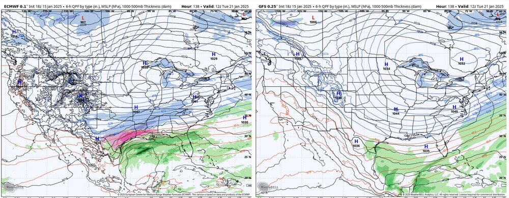
To my eye, the 18z Euro coming in much less amped than the GFS in the gulf. Looks like it might not want to merge that Great Lakes Low like the GFS if it continued past 144hrs, too. HP in Mid Atlantic is a few ticks higher as well.


-
2
-


Mid to long range discussion- 2025
in Southeastern States
Posted
Just saw a Tornado Warning for Spalding County(Griffin)
Tony, you attracting these things?