Awesomesauce81
-
Posts
43 -
Joined
-
Last visited
About Awesomesauce81

-
1/21-1/22 Winter Storm OBS Thread
Awesomesauce81 replied to metalicwx367's topic in Southeastern States
Just saw a few flakes/pellets just now -
1/21-1/22 Winter Storm OBS Thread
Awesomesauce81 replied to metalicwx367's topic in Southeastern States
What part of Savannah you're in? Nothing yet on the westside. -
I don't think I've ever seen such variance between models in regards to precip so close to go time. We're in for a wild ride. I've noticed that we probably won't reach our forecasted high of 41 so I'm wondering how that effects our initial p type.
-
I gotta be selfish and wish for a SE trend atp
-
The UK would definitely be the best solution for our area if we were to get anything
-
Oh heck no. Savannah would be done for
-
The icon has been showing this little feature consistently since Monday. Maybe my boys in Statesboro will see some flurries
-
I'm keeping an eye on it but I prefer cold rain if it ain't snow lol
-
Mid to Long Range Discussion ~ 2024
Awesomesauce81 replied to buckeyefan1's topic in Southeastern States
You've done a wonderful job all winter Larry. It's almost like Mother Nature wants you to keep going lol -
Mid to Long Range Discussion ~ 2024
Awesomesauce81 replied to buckeyefan1's topic in Southeastern States
Yep I'm patiently waiting for Jan/Feb 2028 lol -
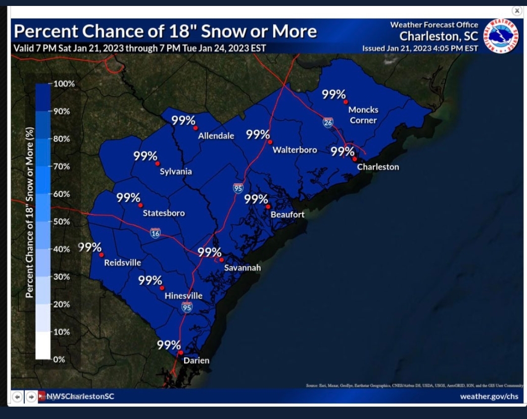
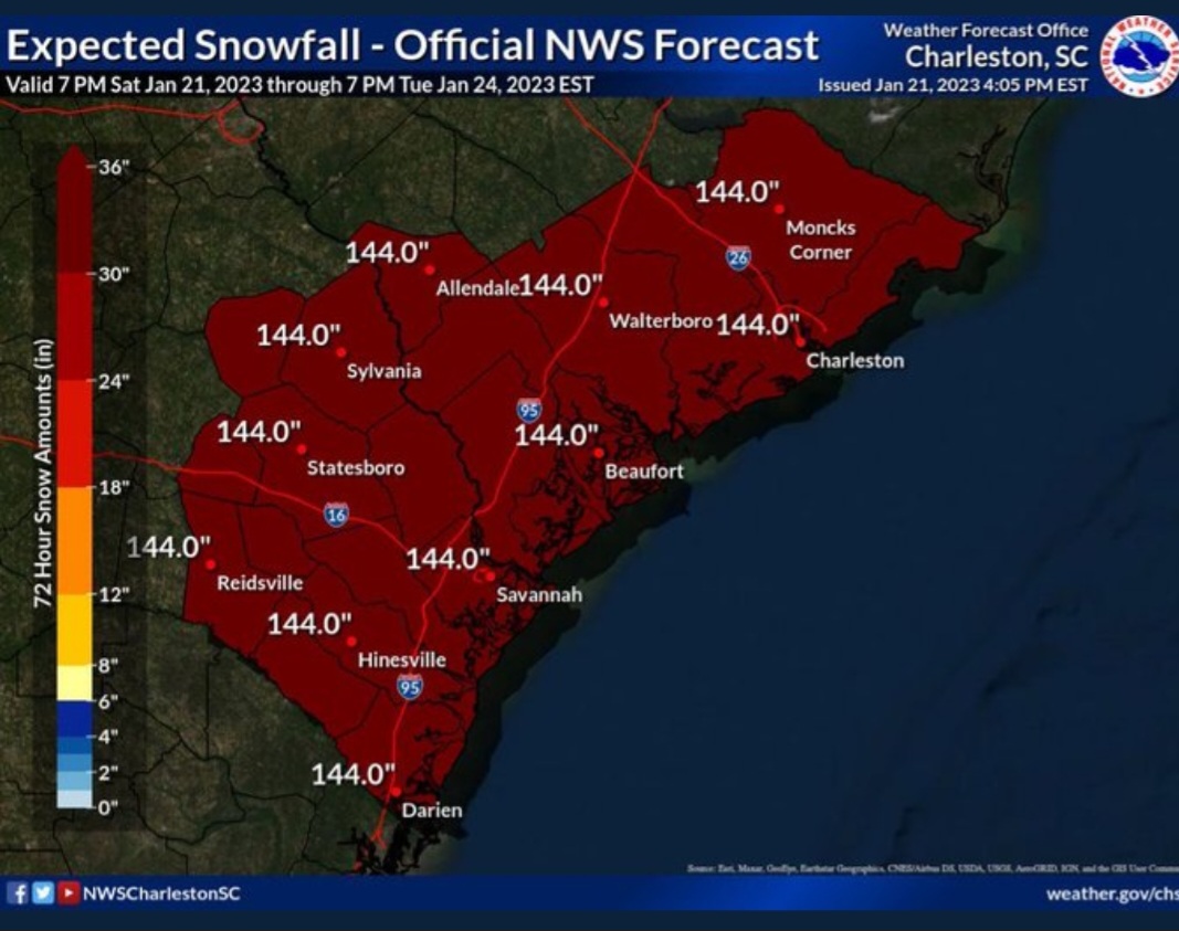
I don't know if this is the right thread for this but NWS Charleston accidentally tweeted this forecast out Saturday. I'm a snow lover but I'm glad this didn't verify lol
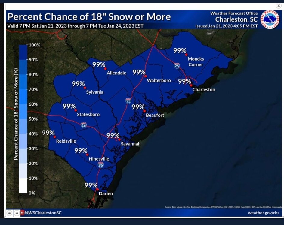

-
Mid to Long Range Discussion ~ 2022
Awesomesauce81 replied to buckeyefan1's topic in Southeastern States
I don't think I've ever seen the GFS this consistent with a fantasy storm this far out, especially at the same timeframe. It's definitely caught my attention. -
Sounds like a perfect storm for a wild NC State win
-
Yet the official totals for KSAV does not reflect your reality ( I don't have official totals in myb but I'm sure I'm closer to your total). This leads me to believe that SAV needs more than one official station like Charleston.
-
Mid to Long Range Discussion ~ 2022
Awesomesauce81 replied to buckeyefan1's topic in Southeastern States
Was just telling a friend of mine that Masters weekend is usually our last cool weekend until October.