astarck
-
Posts
526 -
Joined
-
Last visited
Content Type
Profiles
Blogs
Forums
American Weather
Media Demo
Store
Gallery
Everything posted by astarck
-
I think what they meant to say was 2000 was incredibly dry overall. The month of October 2000 logged only 0.02 inches of rain and was the middle of a very long dry streak. In total, 0.02 fell across 43 days spanning September 26 to November 9. But officially, the longest streak without rain that year was 21 days. Their reporting in this article would agree. https://www.washingtonpost.com/weather/2024/10/22/dc-dry-streak-drought-lanina/
-
34
-
32 for Baltimore.
-
Shorts weather at DCA.
-
Going back in time on satellite images it looks like the last day that had notable clouds during the day was Wednesday October 16. Basically wall to wall sunshine for the last 8 days.
-
Incredible rain around Fredericksburg with radar estimates around 7”.
-
Narrator: They did
-
DCA got its 80 degree low yesterday.
-
This aged poorly.
-
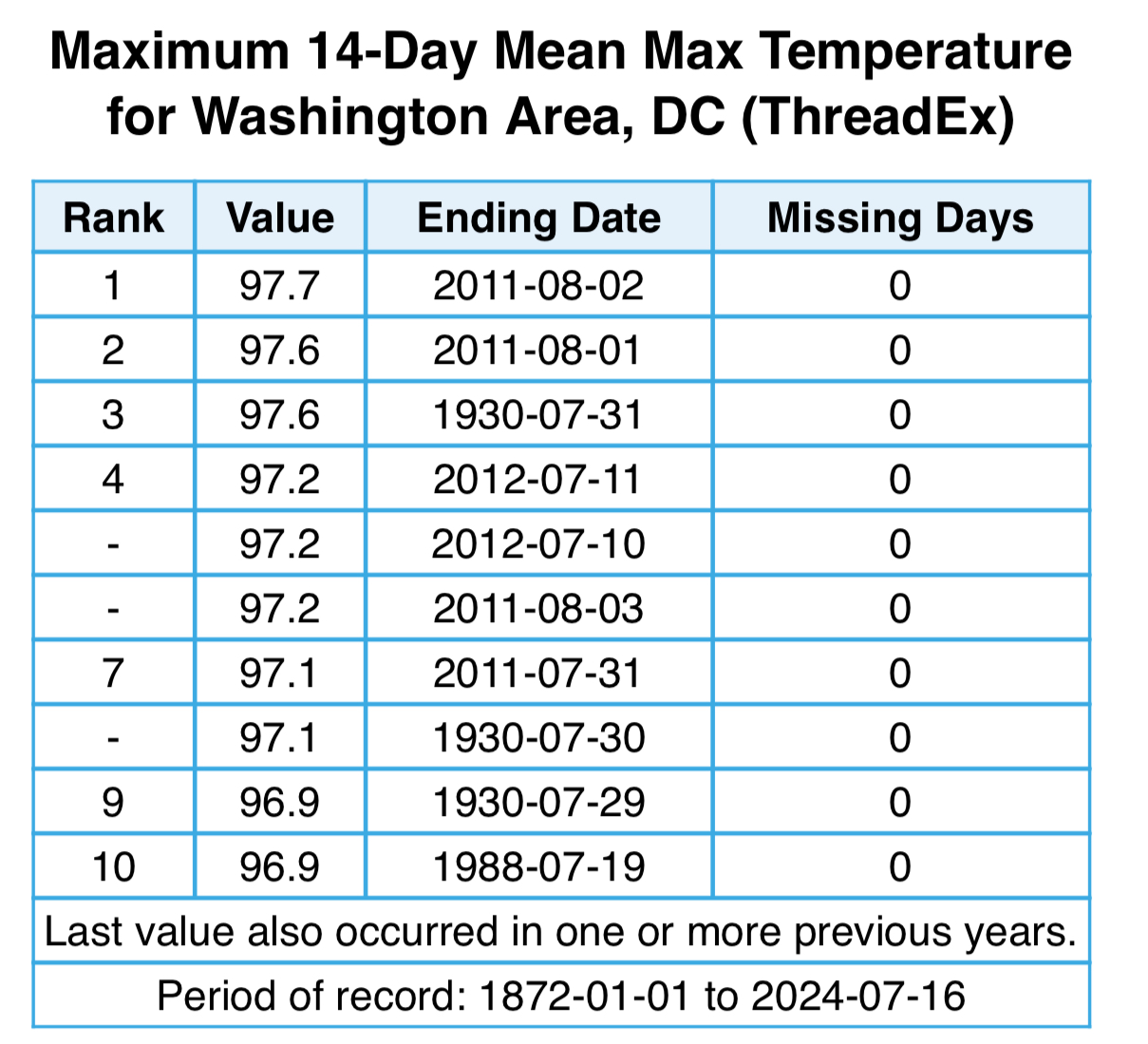
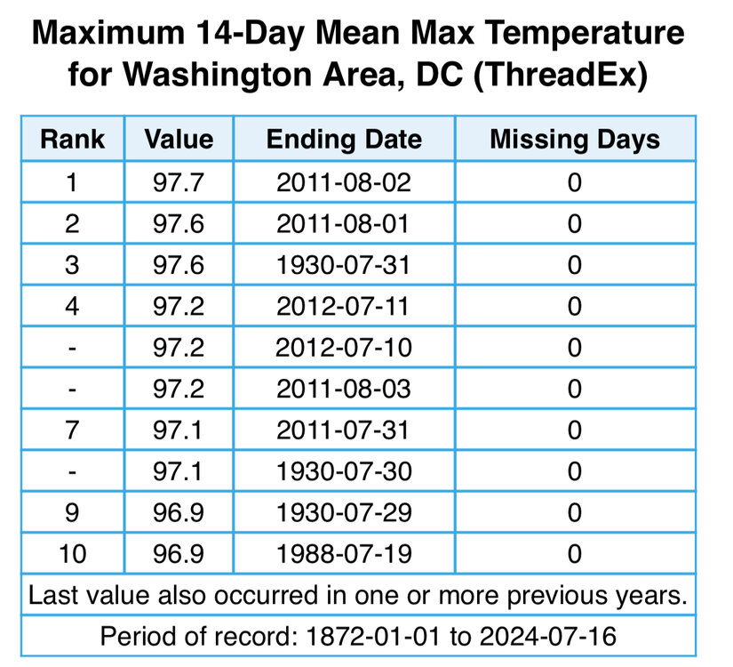
No sooner did I type this that DCA hit 100. That should round us up to 97.3 and breaks the tie with 2012.
-
Assuming the 99 at DCA is the high today, we will have a 14-day stretch with an average high of 97.2. That puts us behind only 1930 and 2011 as the hottest two-week stretch ever.
-
Officially 104, 104, and 101 at the three airports.
-
Make that 101. Roasting.
-
DCA is at 100. Almost two hours ahead of yesterday.
-
If we can avoid the rain today we’ve got it. 80 again last night.
-
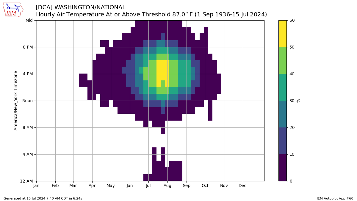
I’ll spare everyone another plot but we’re still tracking with that upper echelon for 95 by 11am.

-
87 at the 8am ob is rarefied air.
-
Not a good sign for Tuesday.
-
DCA getting some jet exhaust at 95°. Strong showing on temps today.
-
Some of the five minute obs were 81. They may have dropped to 80.
-
DCA somewhere around a tenth of an inch. Next!
-
99 at DCA and BWI. 98 IAD. We just missed.
-
A solid 1.5 hours of 99’s on the five-minute obs at DCA. I know those get rounded multiple ways and are likely 98’s, but maybe we snagged a 100 somewhere in there.
-
Lock in another 98+ for DCA. Incredible.