packbacker
-
Posts
11,642 -
Joined
-
Last visited
Content Type
Profiles
Blogs
Forums
American Weather
Media Demo
Store
Gallery
Everything posted by packbacker
-
Southeast Sanitarium - A Place to Vent
packbacker replied to Jonathan's topic in Southeastern States
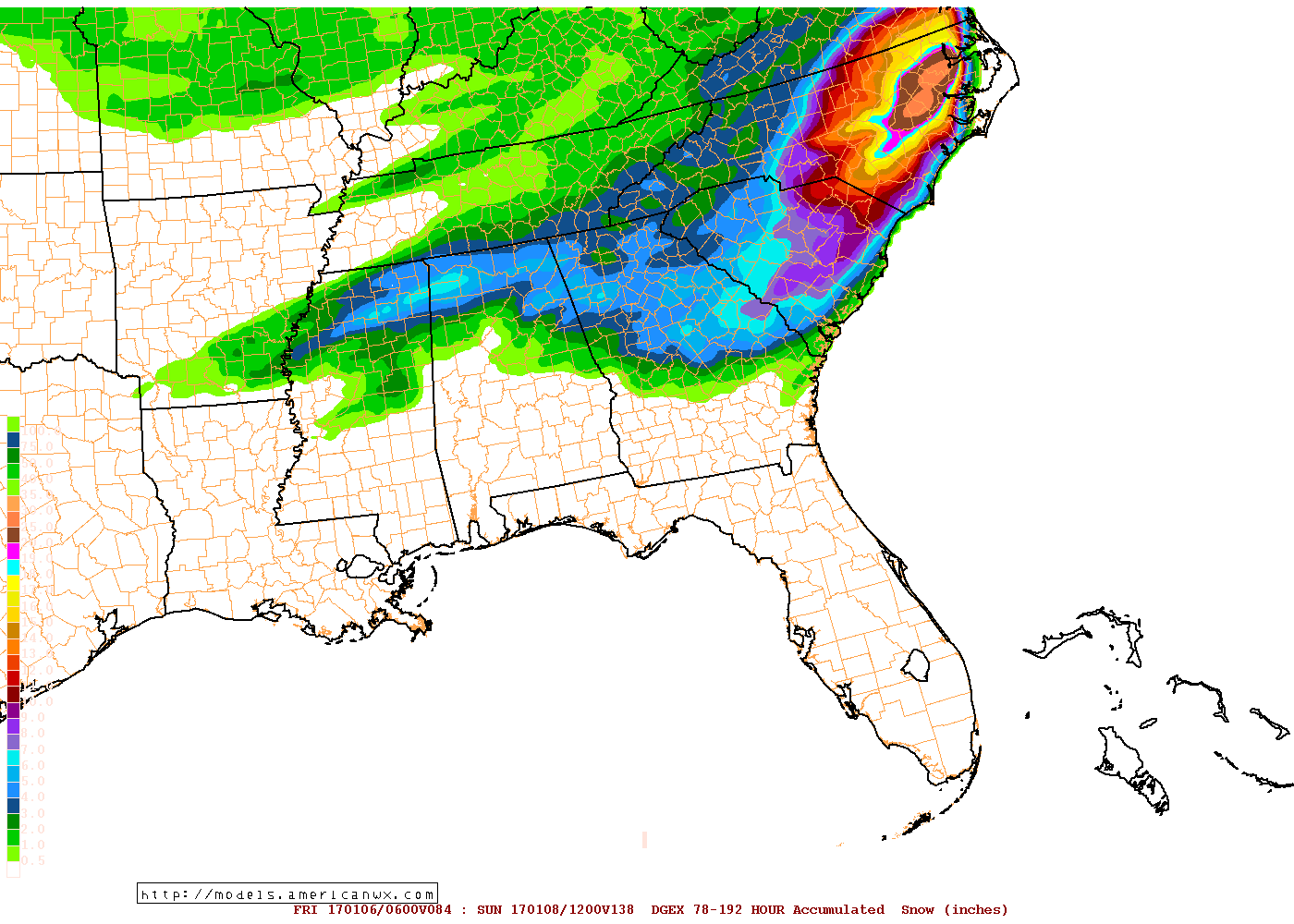
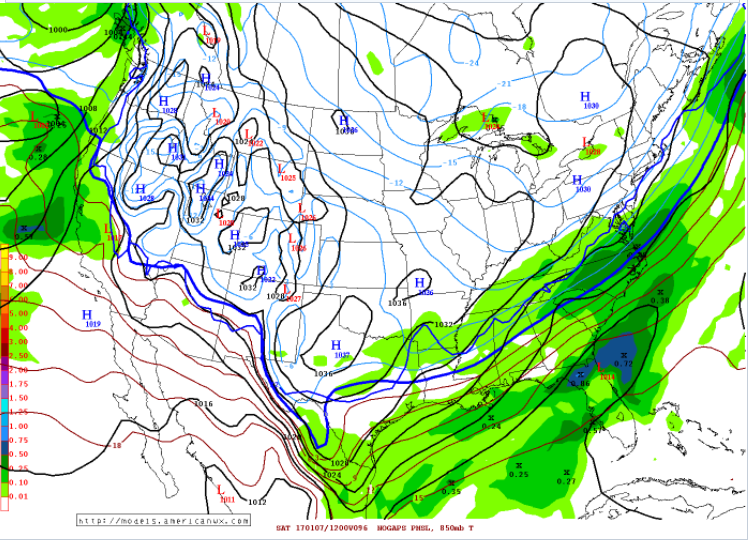
GEM is 1" QPF for you...sweet! 850's start at -6 and roughly stay there with temps dropping into mid 20's.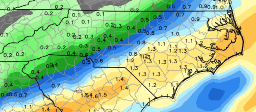
-
Southeast Sanitarium - A Place to Vent
packbacker replied to Jonathan's topic in Southeastern States
Ummmm....it would be Dec 2000 all over again. But, RAH is like 30-40 miles from 1" so a SE shift and yes it would suck. That's something that could change day of the storm. -
Southeast Sanitarium - A Place to Vent
packbacker replied to Jonathan's topic in Southeastern States
Ground temps are a concern but will just make things worse as it will melt and then refreeze...assuming we get any snow. Which I am holding out until 12z runs tomorrow. -
Southeast Sanitarium - A Place to Vent
packbacker replied to Jonathan's topic in Southeastern States
Me too...but we are not getting six. -
Southeast Sanitarium - A Place to Vent
packbacker replied to Jonathan's topic in Southeastern States
Surely he knows now to take the lowest model and divide by 2 or even 3.... -
Southeast Sanitarium - A Place to Vent
packbacker replied to Jonathan's topic in Southeastern States
Tell me about it...how often has the most extreme modeled snow worked for us at this range...NEVER. Especially the Euro, it's the worst at fantasy snow. We always say if we had hugged the warmest/least snowy model we would have had our answer. We never learn...I am hoping 1-3" across the triangle but that takes a NW shift of the GFS. Not that confident of that just yet. -
Southeast Sanitarium - A Place to Vent
packbacker replied to Jonathan's topic in Southeastern States
Well without a wrapped up low whoever wants to jack is going to have flirt with temp issues. Personally would like the GFS where cold isn't an issue but fringes with better qpf. -
Southeast Sanitarium - A Place to Vent
packbacker replied to Jonathan's topic in Southeastern States
What model is this...LOL. Latest run.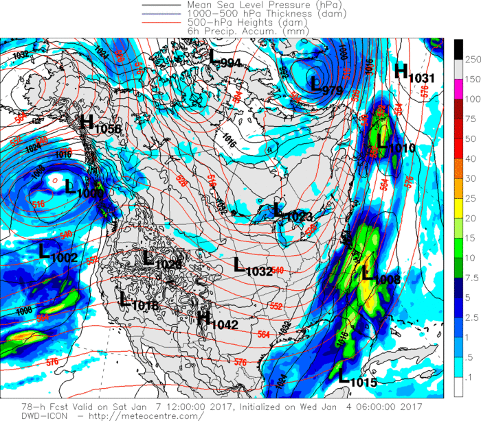
-
Southeast Sanitarium - A Place to Vent
packbacker replied to Jonathan's topic in Southeastern States
I like the DGEX/ukmet blend. -
Southeast Sanitarium - A Place to Vent
packbacker replied to Jonathan's topic in Southeastern States
Why I posted I wasn't sure what I wanted it to show. If I didn't have skin in the game I would think the same so don't want to jinx it. I can't remember an event where the GFS didn't tick NW inside 48 hours. Of course Euro can be a little amped. A blend is usually what happens. -
Southeast Sanitarium - A Place to Vent
packbacker replied to Jonathan's topic in Southeastern States
It was...just venting about thicknesses. 18z GFS should be fun...I don't know whether we want it to hold or shift NW. -
Southeast Sanitarium - A Place to Vent
packbacker replied to Jonathan's topic in Southeastern States
JMA say we taint....be funny if this ends up being a 35F 1" QPF rainer and MA to NE get 10-15". A Dec 09 repeat. -
Southeast Sanitarium - A Place to Vent
packbacker replied to Jonathan's topic in Southeastern States
Even the Navgem is a nice hit.
-
Southeast Sanitarium - A Place to Vent
packbacker replied to Jonathan's topic in Southeastern States
Bulk of globals show snow inside day 4....what could possibly go wrong. There's a reason we don't snow here. -
Southeast Sanitarium - A Place to Vent
packbacker replied to Jonathan's topic in Southeastern States
So GFS is bone chilling cold but suppressed and the Euro is juiced but we taint. Seems like just about every winter around here. The Atlantic ridge just sucks.... At this point I hope this fizzles out so we can get back to normal....watching day 11+ anomaly maps for hope of a pattern change. -
Southeast Sanitarium - A Place to Vent
packbacker replied to Jonathan's topic in Southeastern States
What just happened...we went from only the GFS/Para to now UK/CMC/Para and GFS is weak and progressive. -
Southeast Sanitarium - A Place to Vent
packbacker replied to Jonathan's topic in Southeastern States
Weeklies are ridiculous the last week of Jan into Feb. Cold/snowy...like the GFS model. Fantasy models.... -
Southeast Sanitarium - A Place to Vent
packbacker replied to Jonathan's topic in Southeastern States
DGEX been rock solid.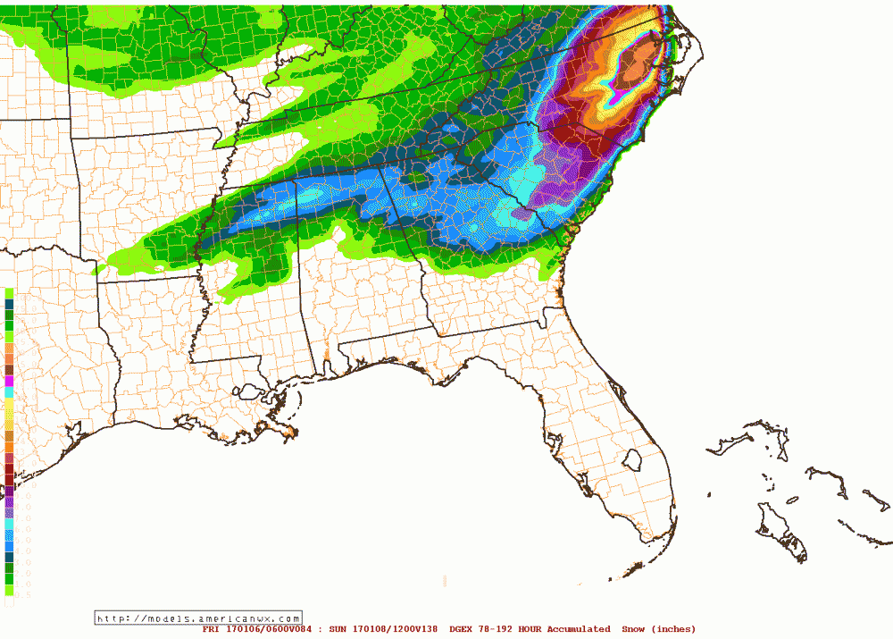
-
Southeast Sanitarium - A Place to Vent
packbacker replied to Jonathan's topic in Southeastern States
North trend starts Wed. :-) Every run the GFS gets a hair slower swinging that trough through. It's getting crazy, by hour 60 you could see it was getting left behind though. I think 0z tonight the GFS steps closer to the Euro. -
Southeast Sanitarium - A Place to Vent
packbacker replied to Jonathan's topic in Southeastern States
Why I posted in this thread...garbage run with only 10-15" across our areas. LOL -
Southeast Sanitarium - A Place to Vent
packbacker replied to Jonathan's topic in Southeastern States
Latest...12z Para...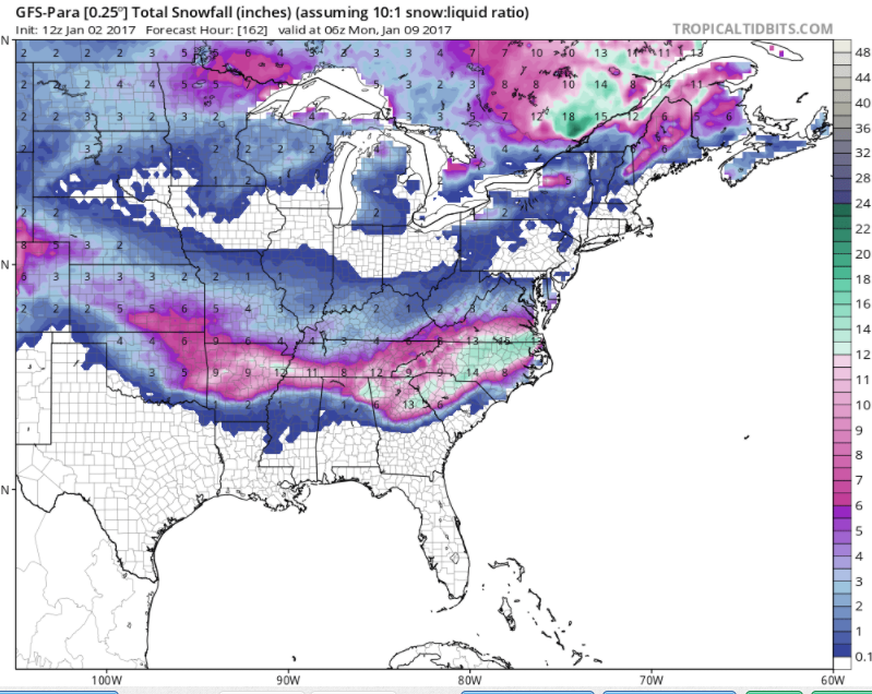
-
Southeast Sanitarium - A Place to Vent
packbacker replied to Jonathan's topic in Southeastern States
We can be warm with blocking and crappy pac (+EPO/-PNA)...ala 2013. To be honest, I really thought/think the PDO will flex sometime this winter, probably later in Jan into Feb. But, that's probably wishful thinking.... -
Southeast Sanitarium - A Place to Vent
packbacker replied to Jonathan's topic in Southeastern States
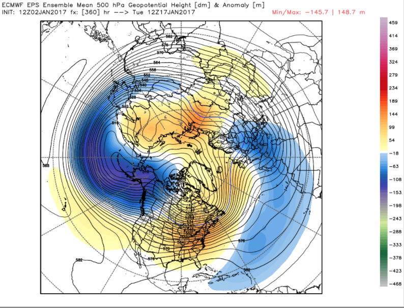
End of GEFS still shows nina forcing at 120E (snoozer)...but GEPS and CFS weeklies start to change that end of Jan. This is a pretty bad look when big low setup over AK....now can we pop a ridge and we get a aleutian low with pac ridge to setup after this? We shall see. If that low really does setup shop then we are in trouble and winter will be over....not saying it will but just if.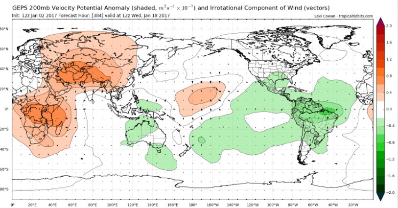
-
Southeast Sanitarium - A Place to Vent
packbacker replied to Jonathan's topic in Southeastern States
Yeah...I think it's going to be warm day 10...all the ensembles agree on that. I think if the pattern changes it will be after the 20th. Though if the -EPO holds then we can get more cold fronts that swing through. -
Southeast Sanitarium - A Place to Vent
packbacker replied to Jonathan's topic in Southeastern States
It's awesome when JI trolls us....especially when he tells us how great the GFS is.