WxKnurd
-
Posts
1,428 -
Joined
-
Last visited
Content Type
Profiles
Blogs
Forums
American Weather
Media Demo
Store
Gallery
Posts posted by WxKnurd
-
-
18 minutes ago, Met1985 said:
Temp down to 31 with moderate snow coming in waves.
Yep that’s what I had, coming in waves. Left the house at 6:30 am with rain and a temp about 60, get back at 4:45 to snow in the upper 20’s. Love our crazy weather days.
-
 3
3
-
-
27 with a dusting on the deck, truck and anywhere with leaves. Finest of flakes falling.
-
1
-
-
7 minutes ago, chris21 said:
So I’m from the DC area (grew up there and lived off and on for 30 years). I’ve also lived in Asheville and am planning on moving to Boone area later this year/early next year. In general, Asheville has a similar snow climo to DC but once you get west and north slightly it improves dramatically. An hour north of Asheville on the Tennessee border some areas average over 90 inches of snow and those areas have at least 30-40 inches on the year. Outside of the northwest flow zone though it’s been pretty awful.
Those areas are about 50% of climo to date if not worst. Not been a good season.
-
1 minute ago, Maggie Ace said:
What has saved ski season this year is weekend time shots of cold air and some fantastic snow making opportunities that were not wasted. Cataloochee in particular could not have survived without the additional snow making equipment purchased last summer. Even Tube World has not closed but a day or two all winter so far.
On to next weekend when we have our next shot of at least NWFS.
Yep timely cold shots is the saving grace for the resorts along with upgraded equipment at places like Sugar, Beech and Cat.
-
1
-
-
Was trying to find this data yesterday and couldn’t but Ski Southeast posted numbers that show how terrible this winter has been snow wise for everyone in the Apps from WV southward. So even those of us with elevation are hurting this year. Don’t know the worst year in terms of snowfall in the last 20 years but I feel like year to date this has to be up there. Let this hybrid La Niña die a fast, painful death not to return for a few years.
-
2
-
-
Well could be all snow at my place as temp dropped from 36 to 33 but won’t be back home til tonight after the game.
-
1
-
-
Definitely some partially melted flakes mixing in when I left the house. Reaffirms my belief it’s a 4500’ and above storm right now unless under heavier returns. Mountain across from me tops out close to 4150’ and it’s Just wet up top as well.
-
2
-
-
All those getting snow enjoy, not looking good for my place right now to see anything more than some mood flakes. Feels like an above 4000-4500’ storm as it stands right now here in NE Haywood. Ah what could have been overnight, maybe the deform band will save this area later this morning and afternoon.
-
3
-
-
Well, it pretty much hung around 32 and rained all night. I’m sure there was sleet mixed in too. 33 and more rain and sleet now.
-
1
-
-
30.7/30 and rain. Deck is wet and a little slushy but thats about it. GSP dead on with the warm nose, now we wait and see if and when changeover is.
-
1
-
-
32 with heavy rain/snow/sleet mix. Deck is getting crunchy. If this switches to and stays all snow sooner rather than later it would pile up IMO.
-
1
-
-
13 minutes ago, Met1985 said:
Im sitting at 34 currently. What's everyone got?
35.6 with the same slop you reported earlier.
-
1
-
-
Moderate sleet, 41/19.
-
2
-
-
48 minutes ago, Maggie Ace said:
Temperature has been dropping steadily the past hour. Was 50 now down to 43. Light NE breeze here in the Valley. It "feels" like snow out there now. Keeping on eye on mPing.
I’ve had a steady drop in dew point the past hour, temp dropped half a degree but dew point has fallen 9 degrees. 43/17 now with a wet bulb down to 33. Gonna be razor close for sure like @Met1985said.
-
1
-
-
43.5/26, 36 for the wet bulb
-
1
-
-
They issued a watch, not a warning guys. Which is refreshing for once because they haven’t issued a watch since I don’t know when. And snow total forecast has been lowered since this morning. It is what it is.
-
2
-
-
25 minutes ago, Bevo said:
Weirdest El Nino-ish La Nina I can remember being in this year.
What's it called when you get the rain of a Nino but the warmth of a Nina?
Seattle
-
 3
3
-
-
3” gives me double digits for the year (and it’s already mid-Feb). I feel like that’s not asking for much just below a 4000’ ridge line in a NWFS area but this winter it seems it is. ULL are so tricky I would not want to be a forecaster whether behind the scenes or in the media. I’m already prepared for Spring to be like all the past recent ones I.e. not Spring like at all and messing up fishing conditions. All I have to say is when the tide changes we are due for a big storm or “bad” (good if you like cold and snow) winter in order to average things out. Cyclical nature and all that.
-
1
-
-
11 minutes ago, wncsnow said:
Thats pretty painful for the foothills but he's usually conservative
He just filtered it by elevation. Looks like he’s saying above 1200’ is where accumulation would be and the. Going from there i.e. above 3500’ =5-7”, above 5000’ = 7-9”.
-
3 minutes ago, Maggie Ace said:
Yes sir! Word is getting out too. Just got a last minute booking at one of our Airbnb's arriving Saturday afternoon until Monday. We have a group skiing now departing Saturday morning and our Cabin is booked with skiers all weekend.
If things hold out through tonight’s runs then I’ll have to start making some contingencies on this weekends plans possibly. Might be no trip to downtown Asheville for a pre-Valentines lunch and festivities on Saturday lol.
-
3
-
-
3 minutes ago, Maggie Ace said:
Incredible hit across Haywood County. I'm a bit concerned there may be some convective feedback on the GFS. 16 inches in Maggie.
Haywood has been the jackpot for the southern mountains every run it seems. 48 more hours to go.
-
3
-
-
Give me a blend of those outputs and I think all us mountain and foothill folks will be happy, especially if you have elevation.
-
2
-
-
Just now, Met1985 said:
The 18z gfs snowfall map.
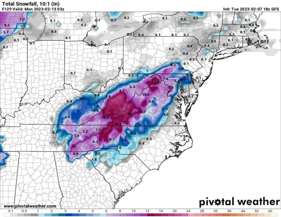
Sent from my SM-G998U using Tapatalk
Can I cash out now? For whatever reason and whatever happens with this weekend, I think we have a few more surprises in store between now and May. Odds say we are due for a big storm in March, mountains seem to average a big one (I’d even say one that has blizzard conditions) about every 30 years it seems (Haywood had ‘34 or ‘36, then you had the end of February and March of 1960 with the 3 straight weeks of storms and finally everyone knows ‘93).
-
4
-
-
Hit 17 around 1-2 am time frame but up to 24 at daybreak.
-
1
-
2022-2023 Fall/Winter Mountains Thread
in Southeastern States
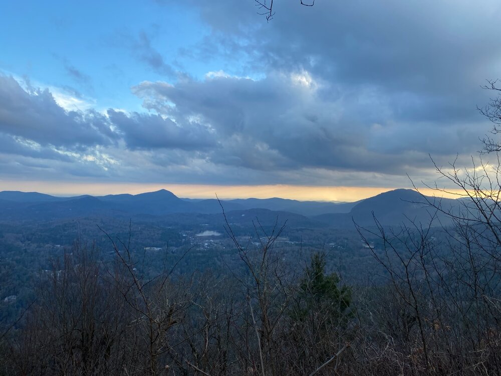
Posted
Beautiful day working down around Cashiers. Took this at the end of my work day from the top of Sheep Cliff Mountain looking over Cashiers and south to SC.