Snowncanes
-
Posts
169 -
Joined
-
Last visited
Content Type
Profiles
Blogs
Forums
American Weather
Media Demo
Store
Gallery
Everything posted by Snowncanes
-
The “I bring the mojo” Jan 30-Feb 1 potential winter storm
Snowncanes replied to lilj4425's topic in Southeastern States
Likely the meso low developing -
The “I bring the mojo” Jan 30-Feb 1 potential winter storm
Snowncanes replied to lilj4425's topic in Southeastern States
The second is a well developed area on regional radar across the eastern Sandhills and southern/central Coastal Plain and is being driven by a strengthening H925 FGEN band. This area is surprisingly not being resolved well within the hi-res guidance, but rather the global and regional models; such as the GFS, Canadian reg/nh, and NAM 12km. These models suggest liquid equivalent of 0.3 to 0.6 will be possible within this area by 18z and would produce 3 to as much as 6 inches (with SLR of closer to 11:1 at this time) before the afternoon hours. If observational trends hold and the global models do handle its evolution well, then as the mid/upper trough negatively tilts and brings significant synoptic forcing overtop this band, it is reasonably possible that 0.75 to 1 inch of liquid equivalent falls and results in a swath of 10-15 inches of snow. This swath would likely fall within a larger area of 4-8 inches in the Coastal Plain into the eastern Sandhills. -
January 30th- Feb 1st ULL and coastal storm obs
Snowncanes replied to JoshM's topic in Southeastern States
If that’s accurate, seems like it’s much closer to the coast than modeled? -
I can’t take this all winter. It’s too stressful lol
-
The “I bring the mojo” Jan 30-Feb 1 potential winter storm
Snowncanes replied to lilj4425's topic in Southeastern States
So I’ve done some digging into the models here recently and I don’t think im entirely buying the dry air thing. Our DGZ is saturated, the 600-850mb layer is saturated, we really are only dry from the 925mb layer down. And that is sitting at about 50-60%RH. I don’t think that will be too hard to overcome and we can wetbulb down to saturated at the ground. Could it eat into our totals for an hour? Sure. Is it going to be as bad as the models think? I don’t think so. We are already seeing snow falling that the models Didnt pick up on. Yes we are between the two areas of greatest forcing but i think the surface low will overpreform and push that out of the way. I just can’t imagine a 970mb low having that small of a precip shield with a negatively tilted 500mb upper low. Im not a met, but I have tracked storms my whole life, so if I’ve missed something please correct me. But thats my two cents. -
The “I bring the mojo” Jan 30-Feb 1 potential winter storm
Snowncanes replied to lilj4425's topic in Southeastern States
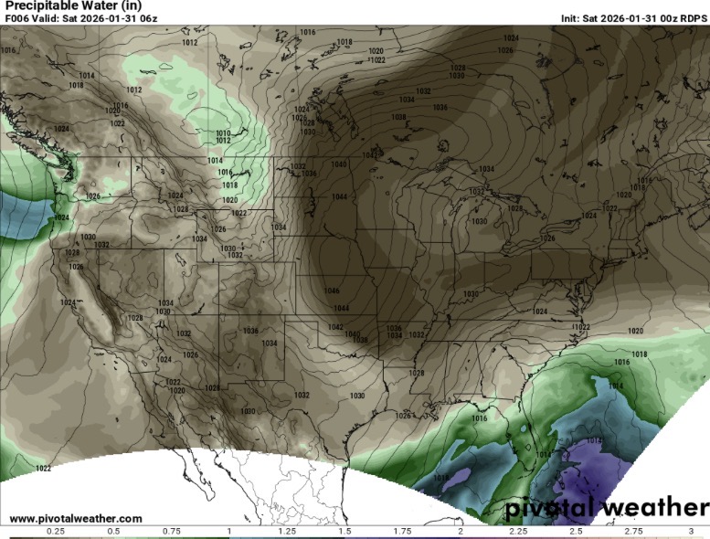
Another thing the RDPS has nailed down of somewhat importance is the PWAT values. (How much available moisture there is in the air). It’s been very consistent over the last 6 runs or so with this as well. If I had to pick a model that seems to be handling this storm the best right now, that would be it.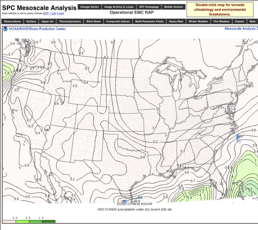
-
The “I bring the mojo” Jan 30-Feb 1 potential winter storm
Snowncanes replied to lilj4425's topic in Southeastern States
Models that are most correct with this feature at this point in time: RDPS, RAP, UKMET, in that order. Doesn’t necessarily mean to treat these as gospel but have a better chance of accurately depicting downstream if you’re not way off of a major feature (looking at you HRRR)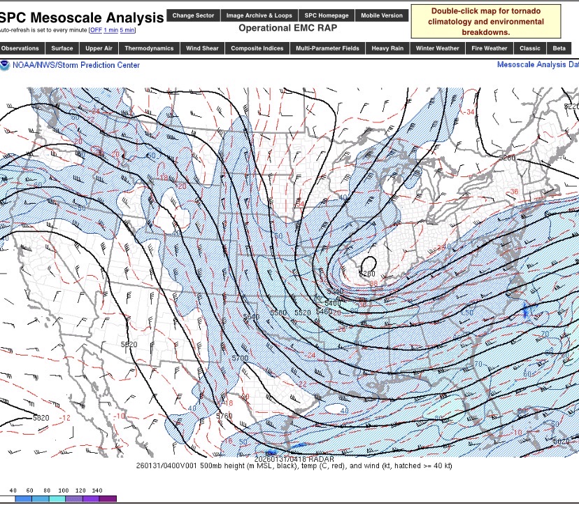
-
The “I bring the mojo” Jan 30-Feb 1 potential winter storm
Snowncanes replied to lilj4425's topic in Southeastern States
Since it’s now casting time, our upper low looks to have closed off over Illinois tonight
-
The “I bring the mojo” Jan 30-Feb 1 potential winter storm
Snowncanes replied to lilj4425's topic in Southeastern States
I forget which one it was, maybe 3k nam, but I’m pretty sure one of the models actually did shear out the ULL on the coast. Thats actually a really good point. -
The “I bring the mojo” Jan 30-Feb 1 potential winter storm
Snowncanes replied to lilj4425's topic in Southeastern States
Yeah im not liking these trends tonight. I guess all we can hope for is that they trend somewhere else. It won’t take much to get back in the game. Hopefully the ULL doesn’t cut as far south and the surface low can interact with it sooner. -
The “I bring the mojo” Jan 30-Feb 1 potential winter storm
Snowncanes replied to lilj4425's topic in Southeastern States
HRRR initialized too dry again. Not sure what the problem is but barely has anything on the radar view while the actual radar has returns over SC, N NC, and the mountains. -
January 30th- Feb 1st ULL and coastal storm obs
Snowncanes replied to JoshM's topic in Southeastern States
Yeah pretty much directly overtop -
January 30th- Feb 1st ULL and coastal storm obs
Snowncanes replied to JoshM's topic in Southeastern States
If you look at the HRRR you can already tell it’s too dry. The NAM is closer. Not really surprising, the HRRR has been initializing dry all afternoon. That’s an elevated warm front. Aka frontogenesis. That’s where theres the most lift and the banding will set up on that model. -
The “I bring the mojo” Jan 30-Feb 1 potential winter storm
Snowncanes replied to lilj4425's topic in Southeastern States
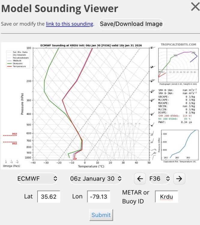
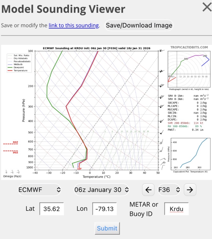
This is the RAP sounding for RDU when it’s showing the dry slot over the area. RH in the dendritic growth zone is 88%. Should be big dendrites as well. Omega is a little low but should be sufficient for snow. I think this is why the dry slots are over modeled.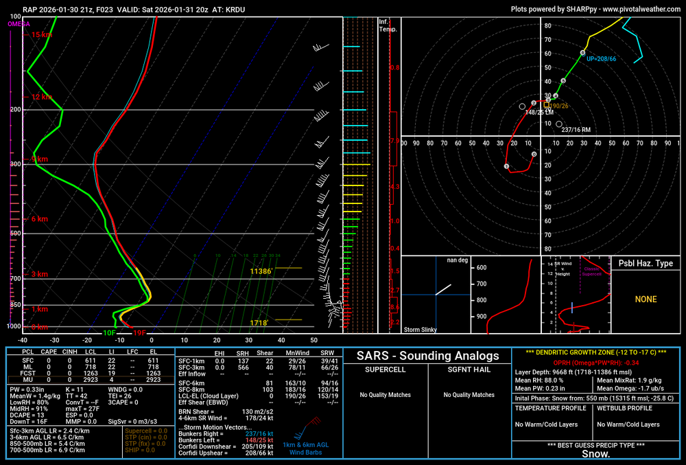
-
The “I bring the mojo” Jan 30-Feb 1 potential winter storm
Snowncanes replied to lilj4425's topic in Southeastern States
Put a piece of wood or cardboard down somewhere (if you really care about getting a perfect measurement) -
The “I bring the mojo” Jan 30-Feb 1 potential winter storm
Snowncanes replied to lilj4425's topic in Southeastern States
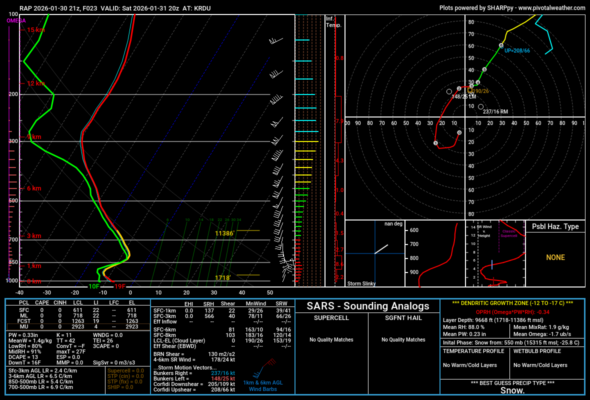
The RAP dry slot can be seen here. Im not sure I would really buy into that not being moist enough for snow growth. Not sure why there’s that tiny dry pocket either. Maybe a Met could explain better than me. I think the HRRR likely has something similar going on.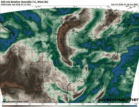
-
The “I bring the mojo” Jan 30-Feb 1 potential winter storm
Snowncanes replied to lilj4425's topic in Southeastern States
https://www.spc.noaa.gov/exper/mesoanalysis/new/viewsector.php?sector=17 -
The “I bring the mojo” Jan 30-Feb 1 potential winter storm
Snowncanes replied to lilj4425's topic in Southeastern States
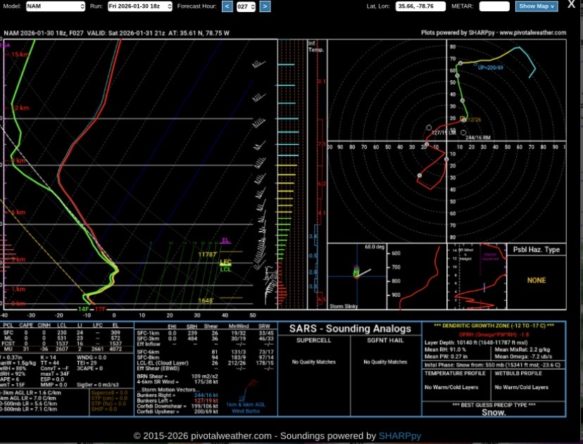
HRRR vs NAM soundings for wake county. That low level dry air just makes no sense, where is it coming from? Also look at the massive DGZ (yellow lines on the right) on the NAM. Thats some beautiful heavy snow.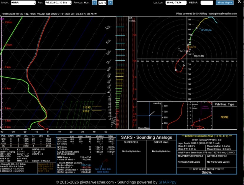
-
The “I bring the mojo” Jan 30-Feb 1 potential winter storm
Snowncanes replied to lilj4425's topic in Southeastern States
I thought that when I saw it too. Wish I had said it so we’d have less cliff diving lol -
The “I bring the mojo” Jan 30-Feb 1 potential winter storm
Snowncanes replied to lilj4425's topic in Southeastern States
Honestly that radar depiction doesn’t even make sense with the Synoptics above. I wouldn’t buy that void. I do wish pivitol had RH% for the HRRR though -
The “I bring the mojo” Jan 30-Feb 1 potential winter storm
Snowncanes replied to lilj4425's topic in Southeastern States
That’s a lot of members over 20” now… wow. -
The “I bring the mojo” Jan 30-Feb 1 potential winter storm
Snowncanes replied to lilj4425's topic in Southeastern States
I feel like the short range models are all trending slower. This storm was supposed to start in central NC around 6z Saturday but now it’s more like 14-18z. Gives that southern energy more time to ride up the edge of the ULL. -
The “I bring the mojo” Jan 30-Feb 1 potential winter storm
Snowncanes replied to lilj4425's topic in Southeastern States
The coast almost definitely -
The “I bring the mojo” Jan 30-Feb 1 potential winter storm
Snowncanes replied to lilj4425's topic in Southeastern States
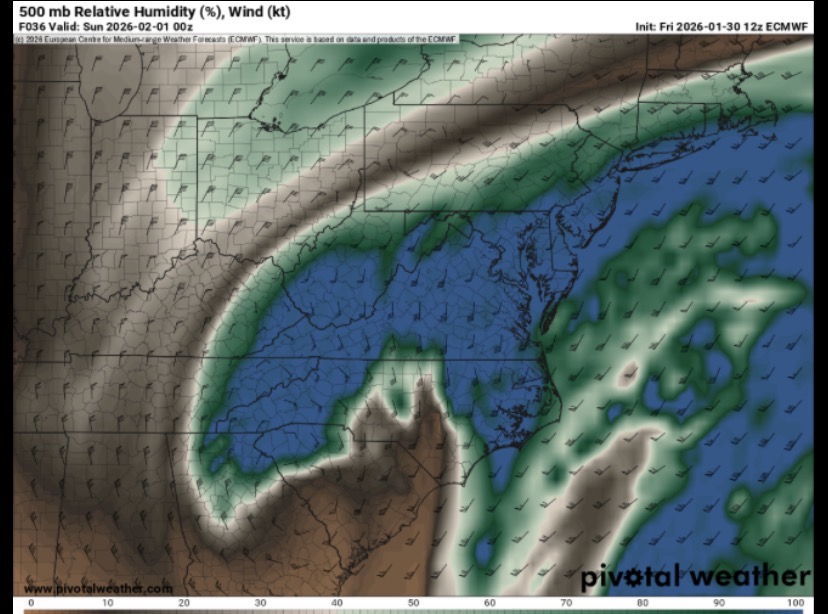
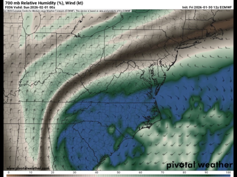
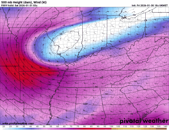
Basically snow grows in a column of air that is roughly -18C to -11C. You need a saturated parcel of air within this temperature range to achieve snow growth. 500mb is a changing height above ground level. Colder air the height is lower, warmer air it’s higher. The maps spit out relative humidity for these mb levels (500,700,850,925). Right now our snow growth will happen mainly below 600mb based on sounding data which is unusual for our area. Normally that growth can start at 500mb. But since the air is so dense and cold that growth area starts lower. https://www.weatherhawks.com/snow-dynamics/ this is an article that I think helps describe snow growth pretty good as well if im still not making much sense haha. -
The “I bring the mojo” Jan 30-Feb 1 potential winter storm
Snowncanes replied to lilj4425's topic in Southeastern States
The problem with his thinking is he is looking at 500mb water vapor. Which typically is fine for NC storms, but this one is so cold that 500mb is in the tropopause and most of the snow growth will happen below that. Heres 500mb and 700mb rel humidity and sounding data