winter_warlock
-
Posts
3,373 -
Joined
-
Last visited
Content Type
Profiles
Blogs
Forums
American Weather
Media Demo
Store
Gallery
Everything posted by winter_warlock
-

January 24-26: Miracle or Mirage JV/Banter Thread!
winter_warlock replied to SnowenOutThere's topic in Mid Atlantic

-
I agree after the way todays storm trended NW over time. I like it exactly where that storm is !!
-
Yes it would have!!! And we wouldn't have thermal issues
-
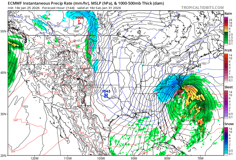
Man it's a shame 18z euro don't go past 144 hrs. Would like to see where this goes
-
January 24-26: Miracle or Mirage JV/Banter Thread!
winter_warlock replied to SnowenOutThere's topic in Mid Atlantic
My kind of Snowman!!
-
January 24-26: Miracle or Mirage OBS Thread!
winter_warlock replied to Jebman's topic in Mid Atlantic
24.6 F. I'm now at 10.3 inches of snow/sleet and I actually have about .10. Ice accretion in my railing so. I now have mix of sleet and ZR falling
-
January 24-26: Miracle or Mirage OBS Thread!
winter_warlock replied to Jebman's topic in Mid Atlantic
My neighbor just told me that a snow plow is stuck about 2 miles away on one of the main roads here. And they had to get a big tow truck to pull it out lol..u know it's bad when snow plows get stuck in the ice and snow!!! -
January 24-26: Miracle or Mirage OBS Thread!
winter_warlock replied to Jebman's topic in Mid Atlantic
Sometimes auto correct picks one for ya lol -
January 24-26: Miracle or Mirage OBS Thread!
winter_warlock replied to Jebman's topic in Mid Atlantic
Still getting heavy sleet here. I'm started out with 7inches of snow and now over 3 inches of sleet.. Incredible amounts of sleet today!! -
January 24-26: Miracle or Mirage OBS Thread!
winter_warlock replied to Jebman's topic in Mid Atlantic
Well I give them to the 16th but they round it off too the tenth. Like if I give them 10.1875. They will put it down as 10.2 -
January 24-26: Miracle or Mirage OBS Thread!
winter_warlock replied to Jebman's topic in Mid Atlantic
Ten-thousandths??? ..Well if you must know.. I'm now using my 48 inch ruler from work.. alot more precise .1875 is 3/16th lol it's not that precise . It's just when I report to skywarn I use decimals not 16th of an inch -
January 24-26: Miracle or Mirage OBS Thread!
winter_warlock replied to Jebman's topic in Mid Atlantic
I'm now at 10.1875 inches . And still have heavy sleet here !! Incredible!! -
January 24-26: Miracle or Mirage OBS Thread!
winter_warlock replied to Jebman's topic in Mid Atlantic
I'm at 23.7 here in sparrows point MD. Temp never even reached 24 today -
January 24-26: Miracle or Mirage OBS Thread!
winter_warlock replied to Jebman's topic in Mid Atlantic
Nice tree!!! And hell there are still people in my neighborhood who have Christmas lights up -
January 24-26: Miracle or Mirage JV/Banter Thread!
winter_warlock replied to SnowenOutThere's topic in Mid Atlantic
-
January 24-26: Miracle or Mirage OBS Thread!
winter_warlock replied to Jebman's topic in Mid Atlantic
I fixed it -
January 24-26: Miracle or Mirage OBS Thread!
winter_warlock replied to Jebman's topic in Mid Atlantic
I'm still sitting at 22 F.. looks like the original forecasted high of 30 here won't come to fruition -
January 24-26: Miracle or Mirage OBS Thread!
winter_warlock replied to Jebman's topic in Mid Atlantic
This storm reminds me of a storm. In 1994 that started as snow but then changed to sleet and I got like 5 inches of sleet on top of 6 inches of snow. Was wild!!!! -
January 24-26: Miracle or Mirage OBS Thread!
winter_warlock replied to Jebman's topic in Mid Atlantic
Sleet is so heavy, can't see across the water to rivera beach!! And the water isn't water, it's frozen all the way across!! 21F temp here in sparrows point MD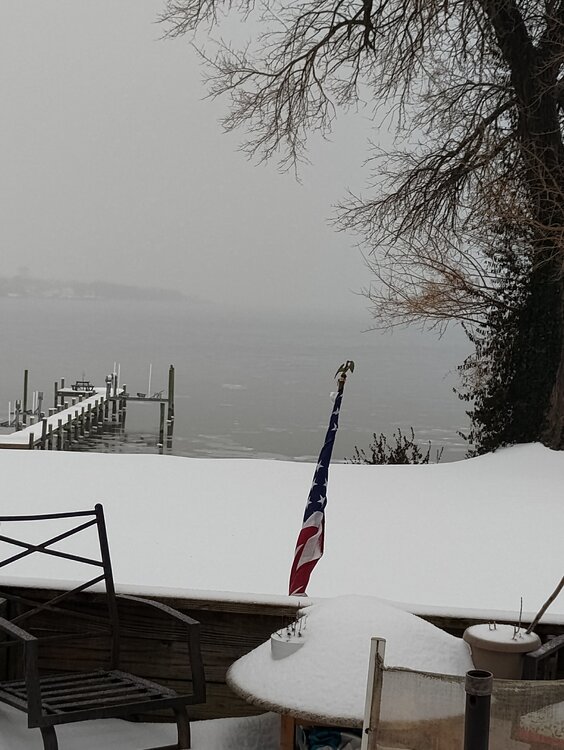
-
January 24-26: Miracle or Mirage OBS Thread!
winter_warlock replied to Jebman's topic in Mid Atlantic
I shoveled for the second time today just trying to keep up with it.. first time was 5 inches of snow.. this second time was 2 inches of snow and 2 inches of sleet. Seemed like it was a lot heavier and I could tell a lot more ice. Wore my ass out!! Lol -
January 24-26: Miracle or Mirage OBS Thread!
winter_warlock replied to Jebman's topic in Mid Atlantic
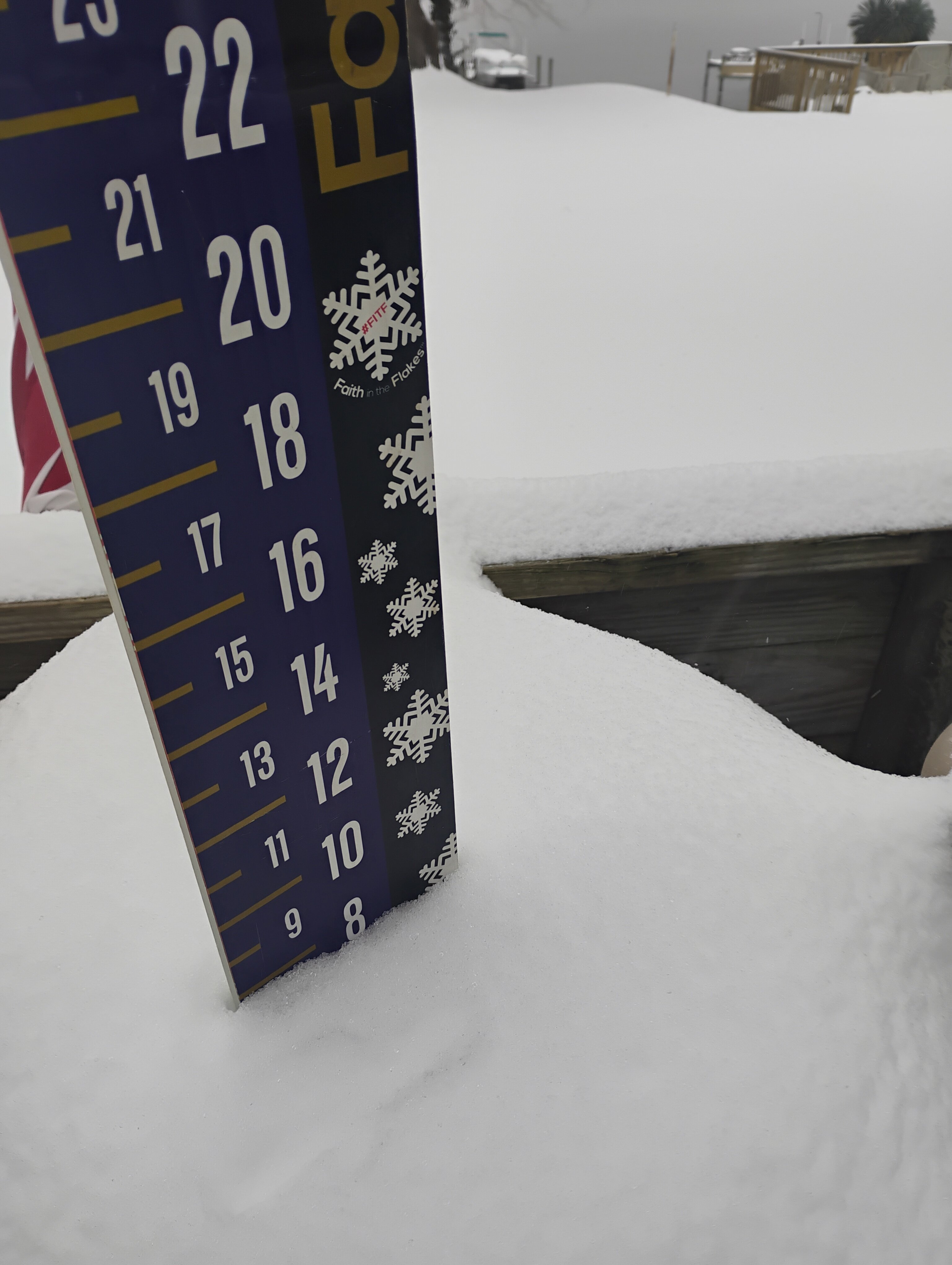
Up to 9.187 inches now in Sparrows point MD!!! Heavy sleet continues!! 20.2 F -
January 24-26: Miracle or Mirage OBS Thread!
winter_warlock replied to Jebman's topic in Mid Atlantic
I'm now up to 8.5 Inches Still getting heavy sleet here. Got .5 inches in last 2 hours.. not too bad considering is sleet 20.1 degreesF -
January 24-26: Miracle or Mirage JV/Banter Thread!
winter_warlock replied to SnowenOutThere's topic in Mid Atlantic
I've now hit 8 inches!! With heavy sleet. 17.3 F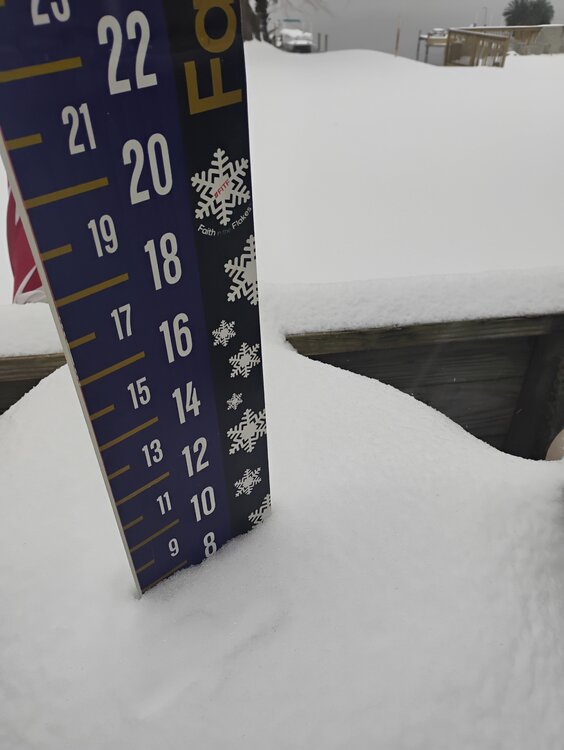
-
Like that trend
-
January 24-26: Miracle or Mirage OBS Thread!
winter_warlock replied to Jebman's topic in Mid Atlantic
Still holding steady at 15.5F. LWX has a high of 31 here I don't see that happeneing