psuhoffman
-
Posts
26,885 -
Joined
-
Last visited
Content Type
Profiles
Blogs
Forums
American Weather
Media Demo
Store
Gallery
Everything posted by psuhoffman
-

Feb Long Range Discussion (Day 3 and beyond) - MERGED
psuhoffman replied to WinterWxLuvr's topic in Mid Atlantic
Para and ukmet have some snow with the wave next weekend. Para has a big storm day 10. -
Jan 31st - 33rd Storm Obs and Disco like it's 1979
psuhoffman replied to Bob Chill's topic in Mid Atlantic
My uncle lives in Shenandoah Junction. Right behind the High and Middle Schools. -
Feb Long Range Discussion (Day 3 and beyond) - MERGED
psuhoffman replied to WinterWxLuvr's topic in Mid Atlantic
If this is what the rest of winter looks like Gefs extended euro weeklies -
Jan 31st - 33rd Storm Obs and Disco like it's 1979
psuhoffman replied to Bob Chill's topic in Mid Atlantic
I’ve come to realize I like the day after a big storm more. I like the scenery of snow on the ground but I’m not a huge fan of it hitting me in the face. Don’t get me wrong it’s awesome when it’s puking snow and piling up. But my favorite part is taking a walk when it’s nice out and there is snow otg. -
Jan 31st - 33rd Storm Obs and Disco like it's 1979
psuhoffman replied to Bob Chill's topic in Mid Atlantic
Been busy. A lot going on at work. I did get out with the kids for a couple hours. -
Feb Long Range Discussion (Day 3 and beyond) - MERGED
psuhoffman replied to WinterWxLuvr's topic in Mid Atlantic
The NAO is likely to reload again after that imo. The TPV is still a weak POS so the next wave break will just start the whole cycle again. -
Feb Long Range Discussion (Day 3 and beyond) - MERGED
psuhoffman replied to WinterWxLuvr's topic in Mid Atlantic
It’s provably becoming true even more so with warmer ocean SSTs. We need those to cool to stop flooding the mid latitudes with warmth. But it certainly happened in the past also. 1958 and 1960 has blocking all winter but it wasn’t until February/March that we cashed in. -
Feb Long Range Discussion (Day 3 and beyond) - MERGED
psuhoffman replied to WinterWxLuvr's topic in Mid Atlantic
Told ya that southeast ridge would be suppressed if the -epo/NAO combo was real. It’s REALLY hard for us to be warm with that combo in February -
Jan 31st - 33rd Storm Obs and Disco like it's 1979
psuhoffman replied to Bob Chill's topic in Mid Atlantic
What’s your total. My original 5-10” call looks better now that part 2 decided to perform. -
Jan 31st - 33rd Storm Obs and Disco like it's 1979
psuhoffman replied to Bob Chill's topic in Mid Atlantic
Hope that dryslot in SE PA NE MD fills in -
Jan 31st - 33rd Storm Obs and Disco like it's 1979
psuhoffman replied to Bob Chill's topic in Mid Atlantic
-
Jan 31st - 33rd Storm Obs and Disco like it's 1979
psuhoffman replied to Bob Chill's topic in Mid Atlantic
That band has arrived and it’s LEGIT! -
Feb Long Range Discussion (Day 3 and beyond) - MERGED
psuhoffman replied to WinterWxLuvr's topic in Mid Atlantic
I remember many many years ago seeing some correlation chart that showed temperature correlations by winter weeks for the major indices. And that I thought oddly the NAO didn’t correlate nearly as much as I expected...UNTIL late January or February then it was like the god of indicators. I’ll have to remind myself of that next time we’re warm during a -NAO early in the season. -
Jan 31st - 33rd Storm Obs and Disco like it's 1979
psuhoffman replied to Bob Chill's topic in Mid Atlantic
Can we get that into NE Carroll pwease -
Jan 31st - 33rd Storm Obs and Disco like it's 1979
psuhoffman replied to Bob Chill's topic in Mid Atlantic
I’m hopeful when that band gets here is when the steady heavy starts here. Got a quick .75” with that nice band an hour ago but it keeps varying and going back to light snow. That band rolling out of York PA now coincides with the arrival of the best deep moisture feed at the mid levels around the deepening (finally phased at all levels) low. The stuff we’ve been in so far had to deal with the pockets of dry air left over from being in the extended SW flow ahead of the stalled h7 before it made the transfer and phased. Shame we didn’t get the euro idea from 3 days ago where the mid and upper lows just amplified right through with no stall and jump. The secondary would have been captured further south and we would be getting what SE PA is. -
Feb Long Range Discussion (Day 3 and beyond) - MERGED
psuhoffman replied to WinterWxLuvr's topic in Mid Atlantic
@WxWatcher007 just tell me who I have to sacrifice to lock this in. Whoever it is I’ll give you a 10 minute head start...then no mercy! -
Jan 31st - 33rd Storm Obs and Disco like it's 1979
psuhoffman replied to Bob Chill's topic in Mid Atlantic
They are in the dead zone under the h7/85 lows. The best moisture feed is north of them then rotating south to their west. -
Jan 31st - 33rd Storm Obs and Disco like it's 1979
psuhoffman replied to Bob Chill's topic in Mid Atlantic
Looks like the pivot point at the base of the h7 low to me -
Jan 31st - 33rd Storm Obs and Disco like it's 1979
psuhoffman replied to Bob Chill's topic in Mid Atlantic
No that actually makes perfect sense. And it’s true. You can see on radar the trajectory pivot and I am mixing with huge flakes now as soon as the banding started to pivot from PA. The moisture feed we’re seeing is being driven by the h7 low and my suspicion is the nasty warm layer that is obviously above 850 is being prevented from mixing by that easterly flow at 700 mb. As that pivots out of the north you will flip quick imo. -
Jan 31st - 33rd Storm Obs and Disco like it's 1979
psuhoffman replied to Bob Chill's topic in Mid Atlantic
Still sleeting here. Good luck with that. Lol. There must be a warm layer above 850. -
Jan 31st - 33rd Storm Obs and Disco like it's 1979
psuhoffman replied to Bob Chill's topic in Mid Atlantic
I got 4.7 but it’s compacted down to about 4.2 from the sleet now. But I’ll take the sleet will help us hold snowcover if we get a warm day. -
Jan 31st - 33rd Storm Obs and Disco like it's 1979
psuhoffman replied to Bob Chill's topic in Mid Atlantic
That storm had a crazy gradient through MD similar to what some models show now. Hanover just north of the PA line had 15” while Westminster only had 7”. -
Jan 31st - 33rd Storm Obs and Disco like it's 1979
psuhoffman replied to Bob Chill's topic in Mid Atlantic
I’ve been stuck in that dryslot for the last 2 hours. -
Jan 31st - 33rd Storm Obs and Disco like it's 1979
psuhoffman replied to Bob Chill's topic in Mid Atlantic
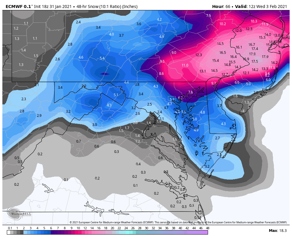
It improved the wrap around across the area tomorrow. This would be snow after 12z tomorrow 10-1 map. Ratios would probably be better. It’s not huge but first improvement in a while with that. I’ve been looking for signs the ccb will activate better. The mid level low to our west seems slightly south of progs and the flow is pretty decent to get moisture transport into the area.
-
Jan 31st - 33rd Storm Obs and Disco like it's 1979
psuhoffman replied to Bob Chill's topic in Mid Atlantic
Euro Euro Euro