

psuhoffman
-
Posts
27,419 -
Joined
-
Last visited
Content Type
Profiles
Blogs
Forums
American Weather
Media Demo
Store
Gallery
Everything posted by psuhoffman
-
it's a two wave system, wave 1 is definitely all snow for DC. Wave 2 night end as some mixed precip DC south but overall 90% of the precip is snow in DC on the AIGFS imo
-
I have never had much interest in the thing later this week. I just don't see the win there...the flow is compressed and deamplifying with not enough ambient cold ahead of the wave...so in order to get enough precip we need a wave to amplify more to our west...but that would also mean warmer...it would take such a perfect thread the needle... But this wave next week I like. As much as I can like something at that range in a flawed but not horrible pattern anyways. Across most guidance it's been a little north but at day 5+ that's actually been where every eventual snow event was at that range...trend has been south from a week out...then back north some at the very end. The pattern looks meh on the means but if you dig in the TPV is displaced into a location that's worked late in the season before. It has some similarities to some of our late Feb early March snows of the past.
-
Don't get me wrong the pattern was perfect. We timed up an extremely perfect AO/NAO with a moderate basin wide Nino which is our perfect STJ configuration for elevated chances at HECS level storms. That right there is the prerequisite we needed to even have a chance at that. But then it also took good luck yes. Put it this way...the pattern was so good that it produced 5 HECS level events somewhere in the east that winter. That was the pattern not luck. BUT...Baltimore got flush hit by 3 of the 5 and a pretty good SECS level snowfall from 1 of the other 2. Out of the 5 huge snowstorms that affect the east coast that winter only 1 missed Baltimore and 3 were flush hit bullseyes! That is good luck. That is us scoring way above our average hit rate. With bad luck maybe we only get 1 of those to hit... average luck maybe 2, getting 3 flush hits was very good luck on top of the perfect pattern. We also got flush hit with some weaker waves, a clipper that put down 2-3" and that little thing in early Feb that gave us 3-6". Perfect pattern plus good luck and...most snow ever.
-
I'll take 103" of snow and I DGAF how warm it is.
-
In terms of snowfall, it was Baltimore's snowiest winter out of about 150 years of records. That alone is a significant data point. Is it possible to get more snow, sure. But that was an anomaly greater than 1 in 150, we don't know how much greater since we don't have more records than that.... so while possible it would take a crazy ridiculous amount of good luck and everything going absolutely perfectly. We have had other winters with a mean pattern almost exactly like 2010 and they didn't end up with that much snow. They were snowy but that took a lot of good luck on top of having a good pattern.
-
Thank you. A moderate basin wide would probably be our best case outcome right now. The winter AO has been trending more negative over the last couple years and the PDO is heading in the right direction, not to a true positive but out of the ridiculous super negative winter cycle we were in. If we get a moderate basin wide next year I'll be pretty optimistic.
-
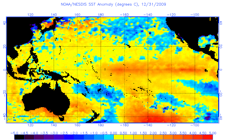
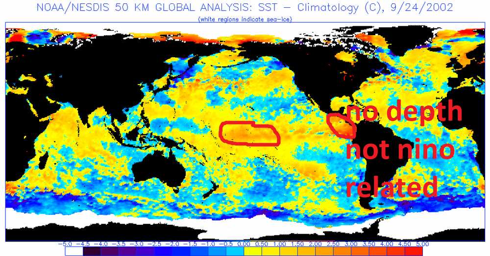
A couple of things I've noted when looking at SST's leading into all our Ninos and our snowfall results. How the Nino starts has more impact than how it ends, unfortunately. A true Modoki starts out west based (which is rare, most start east and evolve west but those don't have as much positive impact on our snowfall as ones that start and stay west based) I think a true Modoki is unlikely at this time. 2002/3 was a perfect classic example of a Modoki nino If you ignore the anomalies right along the central america coast which were not completely related to the nino, those would actually have been slightly SW of there in a true east based nino, the core of the warmest anomalies at the inception of the nino in September 2002 was clearly out near the dateline. A true Modoki. But a basin wide representation ups our chances of a truly massive snowfall over an east based. The strength matters. The best seems to be a moderate basin wide. 2010 fell into this category. If a basin wide goes strong it becomes like 1983 and 2016, much warmer but still with an increased chance of a massive storm if we can just time one STJ wave up with just a cold enough airmass. Basin wide events actually have the highest correlation with HECS storms! Below is how I would categorize the different options. I am only categorizing moderate to strong here because weak ninos are a wildcard. IF they gain the necessary strength to impact the pattern they act like a moderate. If they do not, the winter tends to behave more like an enso neutral. Somewhere between weak and moderate is a tipping point where a nino actually behaves like we think of as nino. But let's assume this next event is strong enough to reach that threshold...then the chart below is what I've noted looking at all our enso events From best to worst although this is subjective True Modoki Event strong or moderate: the strentgh of a true modoki doesn't seem to matter as much, but a true modoki event has never attained super nino status, they seem to cap at borderline moderate/strong. A true modoki typically ends up more EPO driven than NAO, colder, more moderate snow threats, but with more events due to the enhanced STJ. Moderate basin wide: Our best chance at a HECS storm AND a colder nino if we get the NAO to cooperate. 2010 is the perfect example of when this type goes right Strong basin wide: elevated chance of a HECS but overall a warm winter is likely, Think 1983 and 2016 moderate east based: These tend to be somewhat warm winters but have produced some snowy periods if we can get cold for a few weeks with the enhanced STJ but overall they average out to slightly below avg snowfall for Baltimore Strong East based: disaster, they are wall to wall torch winters, think 1998
-

Feb 22nd/23rd "There's no way..." Obs Thread
psuhoffman replied to Maestrobjwa's topic in Mid Atlantic
5.8" -
Feb 22nd/23rd "There's no way..." Obs Thread
psuhoffman replied to Maestrobjwa's topic in Mid Atlantic
Then why is DC and Baltimores average snowfall declining? -
Feb 22nd/23rd "There's no way..." Obs Thread
psuhoffman replied to Maestrobjwa's topic in Mid Atlantic
Chuck I accounted for Decadal flux in my 30% statement. If we used the last 10 years as a judge Baltimore has lost over 50% of its snowfall since 100 years ago baltimore averaged about 27" and they are averaging about 12" the last 10 years. My 30% loss is based on its long term mean snowfall regression factoring in shorter turn fluxuations. Yes we have been in a particularly bad cycle and that is why over the last 10 years Baltimore is about 55% below normal. That will go up...we will have some -NAO+PDO cycle where Baltimore Averages 20" someday. But they probably will never have a period where they average close to 30" again like they did 100 years ago! The ups are less up and the downs are more down. This current cycle is 20% worse than the previous worst 8-10 year periods on record! You are acting like warming isn't hurting but it is...clearly. The cycle is making it even worse but the long term 100 year trend in snowfall is down regardless of the short term patterns. -
Feb 22nd/23rd "There's no way..." Obs Thread
psuhoffman replied to Maestrobjwa's topic in Mid Atlantic
I'm genuinely confused what part of this is even remotely controversial or complicated. The boundary is warming. That is a fact. And over the last 10 years there have been a number of storms where boundary temps were very marginal...within a degree or two of freezing in my area for a large part of the storm, where any colder would have helped me quite a bit. I can't tell you how much. No I can't say it would have been exactly 1f or 2f or 3f colder at a specific year. But it would have been colder. and ANY colder would have meant more snow. 30 years ago I would have got more snow from todays setup. I can't say if it would have been 1" more or maybe 4" more but it would have been more...why do we need to debate about exactly how much more. We do know that DC and Baltimore have lost about 30% of their snow on the whole to warming. While we can't predict exactly what it means to a specific storm the ones with marginal boundary temps are the ones being impacted most. I really really really don't get why this is even a controversial thing, its common sense. ETA: and the delmarva and NJ would have had more snow also! They lost snow to rain today also before it flipped and then had crazy low rations...a little colder and places that get 12" might have got 15 or 18". So even there it hurt them. -
Feb 22nd/23rd "There's no way..." Obs Thread
psuhoffman replied to Maestrobjwa's topic in Mid Atlantic
Remember that well. I was in Herndon VA. For about 8” there too -
Feb 22nd/23rd "There's no way..." Obs Thread
psuhoffman replied to Maestrobjwa's topic in Mid Atlantic
I think that’s a good estimate. I think some misunderstand when I say it’s hurting. Like last weekend. I didn’t think I should have got some 10” storm. But I do think 30 years ago that was a 2-3” snow instead of .4 qpf of slush bombs at 34-35 degrees. It’s hurting on the margins. And it all adds up. Not saying some 3” storm should have been 20” or anything crazy. But you add a couple other minor events. Tack on an inch here or there and some of these years aren’t as dreg. -
Feb 22nd/23rd "There's no way..." Obs Thread
psuhoffman replied to Maestrobjwa's topic in Mid Atlantic
Can we get that to rotate east some please -
Feb 22nd/23rd "There's no way..." Obs Thread
psuhoffman replied to Maestrobjwa's topic in Mid Atlantic
IVT -
Feb 22nd/23rd "There's no way..." Obs Thread
psuhoffman replied to Maestrobjwa's topic in Mid Atlantic
The thing is we can get stuck on exactly how much colder it would have been in 2000/1970/1950… yes the 2f/3f figure is an average. But it would have been colder. And any colder would have helped. I can’t say how much. Would I have got 6” instead of 5? Or 7 or 8. I dunno. But I find it weird that people are getting stuck on that specific “we can’t say exactly how much it’s hurting” argument. Yes we kinda do. On the whole DC has gone from 25” to 14” over 100 years. Maybe we can attribute some of that to the location change so let’s say the real figure is 25 to 17. That’s still a very significant decrease! No we can’t say each storm exactly how it would have been different but we know we’ve lost about 30% of our snowfall. Same at Baltimore. Why get stuck on “well exactly how much did it hurt”. It hurt. It is hurting. We are snowing less because it is warmer. Some storms it impacts more than others but when we’re borderline temps seems pretty obvious to me those are the most impacted. -
Feb 22nd/23rd "There's no way..." Obs Thread
psuhoffman replied to Maestrobjwa's topic in Mid Atlantic
Loved you in the East West all star game -
Feb 22nd/23rd "There's no way..." Obs Thread
psuhoffman replied to Maestrobjwa's topic in Mid Atlantic
On a micro scale somewhere will get 8-10 from the IVT yes. But the way they increased a large area indicates it wasn’t IVT related. Unless they are just hedging and know they will bust high where the IVT misses. Just wondering. -
Feb 22nd/23rd "There's no way..." Obs Thread
psuhoffman replied to Maestrobjwa's topic in Mid Atlantic
I was being honest. I never would have even gone 5-10. I was thinking 4-8 and I’d be dropping it right now to 3-7 maybe not increasing it. I honestly want to know what went into their decision. Maybe I’m missing something and I can learn. -
Feb 22nd/23rd "There's no way..." Obs Thread
psuhoffman replied to Maestrobjwa's topic in Mid Atlantic
Be careful -
Feb 22nd/23rd "There's no way..." Obs Thread
psuhoffman replied to Maestrobjwa's topic in Mid Atlantic
NWS just upped me to 8-12. Am I missing something? Hope they are right and I’m way wrong. -
Feb 22nd/23rd "There's no way..." Obs Thread
psuhoffman replied to Maestrobjwa's topic in Mid Atlantic
Thank you. I really appreciated the reply. Seems we are much closer on thinking and you can’t and shouldn’t have to justify others decisions lol. I was just perplexed because while there was some model support for that 5-10 call it relies on a decent amount of accumulation today. The NAMs and the SREF and RAP all showed what would justify a 5–10 call. But they all had accumulating snow today. The forecast went non accumulating today which was correct but still higher totals. Seemed like a weird combo of two opposite scenarios. Maybe a hedge? -
Feb 22nd/23rd "There's no way..." Obs Thread
psuhoffman replied to Maestrobjwa's topic in Mid Atlantic
Respectful question. Not trying to be critical just trying to understand rationale. My forecast is 5-10”. But it’s clear it’s too warm today and snow won’t start to stick until after 4pm or so. And the forecast kinda indicates this. But it’s also been clear to me there won’t be enough QPF to reach those totals if we lose all the precip today! I’ve been doing this math for 24 hours now and not getting it because the model runs that showed 5-10” also snowed 3-5” of that falling today right now! And the runs that didn’t only have me getting 3-5” not 5-10. There has never been anything that shows no snow until this evening AND 5-10”. There isn’t enough qpf left after 5pm for that. I only see about .3-.4 qpf across guidance after 5pm. So I guess I’m confused. What’s the thinking on the 5-10” forecast with all the snow coming tonight when everything I see indicates half the storm is over by then and only .3-.4 qpf left tonight up here. -
Feb 22nd/23rd "There's no way..." Obs Thread
psuhoffman replied to Maestrobjwa's topic in Mid Atlantic
Probably rate dependent south of 70 given the marginal wet bulbs until after 3pm. If we get a steady heavy enough precip coverage it would help. -
Feb 22nd/23rd "There's no way..." Obs Thread
psuhoffman replied to Maestrobjwa's topic in Mid Atlantic
Tell her not to date any of them


