Nomz
-
Posts
639 -
Joined
-
Last visited
Content Type
Profiles
Blogs
Forums
American Weather
Media Demo
Store
Gallery
Everything posted by Nomz
-
... it is sickening that PA/NYC/SNE are robbing us though
-
If you told me a week ago we'd get 8 inches in DC, I'd be happy. So I'm happy.
-
Apple weather is still showing 20-25 inches in DC… some people are going to be very disappointed.
-
Yeah I'd say there's a pretty solid consensus that, no matter where the sleet line sets up, it sets up about parallel to the Blue Ridge
-
Icon doesn’t really make sense to me with warmer 700mb temps due west of DC
-
From my experience the NAM overdoes low-level response which leads to a stronger LLJ, warmer temps and (for severe weather season) loopier hodographs.
-
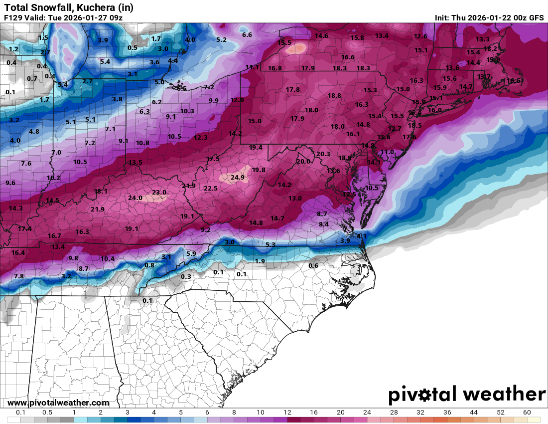
As the LWX AFD mentioned, I'd use the 10:1 instead of the Kuchera for now. Even though most of the initial thump will have good ratios, towards the end, it'll get closer to the gray area, probably leading to somewhat wetter snow and smaller ratios.
-
That's a lottttt of freezing rain. I'd wager at least half of that is sleet instead.
-
Sounds like a hold. Assuming EPS and AI EPS are nominal, I think I'm gonna bump to 6-10"+ tomorrow morning.
-
on 10:1 as well
-
riding the knifes edge man
-
Even though the 00z GFS had some sleet (not much) it still absolutely dumped us. Some sleet is not game over for DC/NOVA/MD.
-
Call it a HECS?

-
NWS LWX posted an AFD about an hour ago. Too much to fit in one post but anyone who hasn't seen it should check it out.
-
Oh yeah if the second wave is real we don't have a chance of catching any of it.
-
Looks like a second wave of QPF coming behind our snow? Not really sure where thats coming but it really nails PA and NY.
-
I'd be fine locking in the ICON as it is now. Probably at least 10 inches before we transition.
-
Does this ICON have the hallowed new data? Or is it just ECMWF and American models
-
Is there a rule of thumb for QPF falling as frozen rain to accumulated ice? Does it vary wildly with surface temps?
-
Probably midnight Saturday night. Duration doesn't feel very hashed out right now.
-
Kept my forecast for DC at 4-8 for tonight. Nowhere near enough model agreement to go one way or another.
-
Thats actually... not that bad! I'll take it. Is it just American models that get recon data, or do Euro, UK, Canadian, etc., get it?
-
GFS should talk some people off the ledge
-
I still trust the straight as an arrow EURO AIFS... would trust it more if GFS fell in line though.
-
Is there anything concrete I can pick out from raw recon data that would be good/bad or am I just playing the waiting game