

Nomz
-
Posts
705 -
Joined
-
Last visited
Content Type
Profiles
Blogs
Forums
American Weather
Media Demo
Store
Gallery
Everything posted by Nomz
-
The Jan 31 Potential: Stormtracker Failure or 'Tracker Trouncing
Nomz replied to stormtracker's topic in Mid Atlantic
So, so much better than 12z: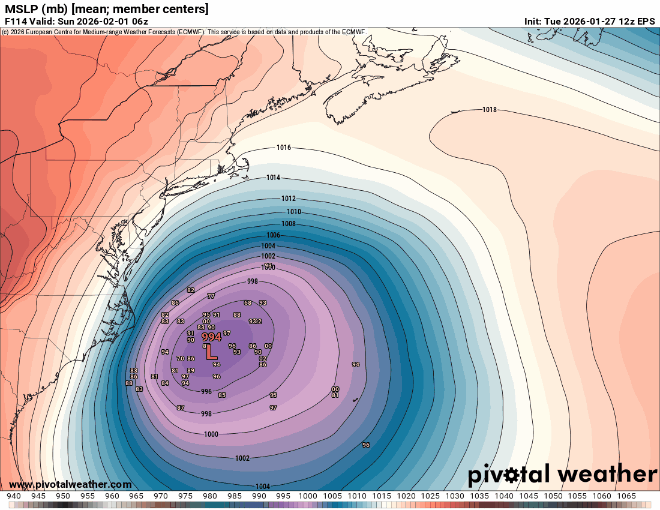
-
The Jan 31 Potential: Stormtracker Failure or 'Tracker Trouncing
Nomz replied to stormtracker's topic in Mid Atlantic
Yep, a lot less OTS outliers and the cluster shifted a fair bit NW -
The Jan 31 Potential: Stormtracker Failure or 'Tracker Trouncing
Nomz replied to stormtracker's topic in Mid Atlantic
EPS 00z Mean is NW of 12z, don't think its enough though. -
The Jan 31 Potential: Stormtracker Failure or 'Tracker Trouncing
Nomz replied to stormtracker's topic in Mid Atlantic
I was 5 -
The Jan 31 Potential: Stormtracker Failure or 'Tracker Trouncing
Nomz replied to stormtracker's topic in Mid Atlantic
EPS might come in way more NW than op if the 500mb looks that much better. Will say the euro looks leaps and bounds better than it did at 12z, but not as good as 18z (at least aifs) -
The Jan 31 Potential: Stormtracker Failure or 'Tracker Trouncing
Nomz replied to stormtracker's topic in Mid Atlantic
GFS: Good, waiting for north trend NAM: Good Canadian: looked good before weird surface modeling Euro OP: West Euro AIFS: West Icon: West UKL West -
The Jan 31 Potential: Stormtracker Failure or 'Tracker Trouncing
Nomz replied to stormtracker's topic in Mid Atlantic
there will be blood -
The Jan 31 Potential: Stormtracker Failure or 'Tracker Trouncing
Nomz replied to stormtracker's topic in Mid Atlantic
Just checked 700 and 850 temps on the most aggresive runs and we're nowhere near the danger zone thank god I would have ended it -
The Jan 31 Potential: Stormtracker Failure or 'Tracker Trouncing
Nomz replied to stormtracker's topic in Mid Atlantic
still haven't seen a screenshot of the 18z run that isn't a single ensemble member. -
The Jan 31 Potential: Stormtracker Failure or 'Tracker Trouncing
Nomz replied to stormtracker's topic in Mid Atlantic
it got me aroused for sure -
The Jan 31 Potential: Stormtracker Failure or 'Tracker Trouncing
Nomz replied to stormtracker's topic in Mid Atlantic
Been OTS every run -
The Jan 31 Potential: Stormtracker Failure or 'Tracker Trouncing
Nomz replied to stormtracker's topic in Mid Atlantic
Nor an SEC championship -
The Jan 31 Potential: Stormtracker Failure or 'Tracker Trouncing
Nomz replied to stormtracker's topic in Mid Atlantic
I wouldn't even be mad if a fujiwhara effect screwed us out of snow. This is some 1991 Perfect Storm shit. -
The Jan 31 Potential: Stormtracker Failure or 'Tracker Trouncing
Nomz replied to stormtracker's topic in Mid Atlantic
I'm actually laughing, the two cold cores just fujiwhara'd around each other. Never seen a model do that with non-tropical lows. -
The Jan 31 Potential: Stormtracker Failure or 'Tracker Trouncing
Nomz replied to stormtracker's topic in Mid Atlantic
Yeah not believing this run lol -
The Jan 31 Potential: Stormtracker Failure or 'Tracker Trouncing
Nomz replied to stormtracker's topic in Mid Atlantic
Is this like when GFS initiates on a weak TS and it progs too much vort in the outer banding and jumps the low there? -
The Jan 31 Potential: Stormtracker Failure or 'Tracker Trouncing
Nomz replied to stormtracker's topic in Mid Atlantic
I bet that western low deepens and the east low fills in -
The Jan 31 Potential: Stormtracker Failure or 'Tracker Trouncing
Nomz replied to stormtracker's topic in Mid Atlantic
It's a more classic setup. Cyclogenesis is pretty easy to infer from 500mb, and 500mb at f140 is easier to infer from f60. -
The Jan 31 Potential: Stormtracker Failure or 'Tracker Trouncing
Nomz replied to stormtracker's topic in Mid Atlantic
all caps folks -
The Jan 31 Potential: Stormtracker Failure or 'Tracker Trouncing
Nomz replied to stormtracker's topic in Mid Atlantic
Can we get another JV/banter thread -
The Jan 31 Potential: Stormtracker Failure or 'Tracker Trouncing
Nomz replied to stormtracker's topic in Mid Atlantic
Still a whiff though, unless I'm looking at the wrong model run -
The Jan 31 Potential: Stormtracker Failure or 'Tracker Trouncing
Nomz replied to stormtracker's topic in Mid Atlantic
Full kuchera map. I'd rather be us now than us 10 hours ago.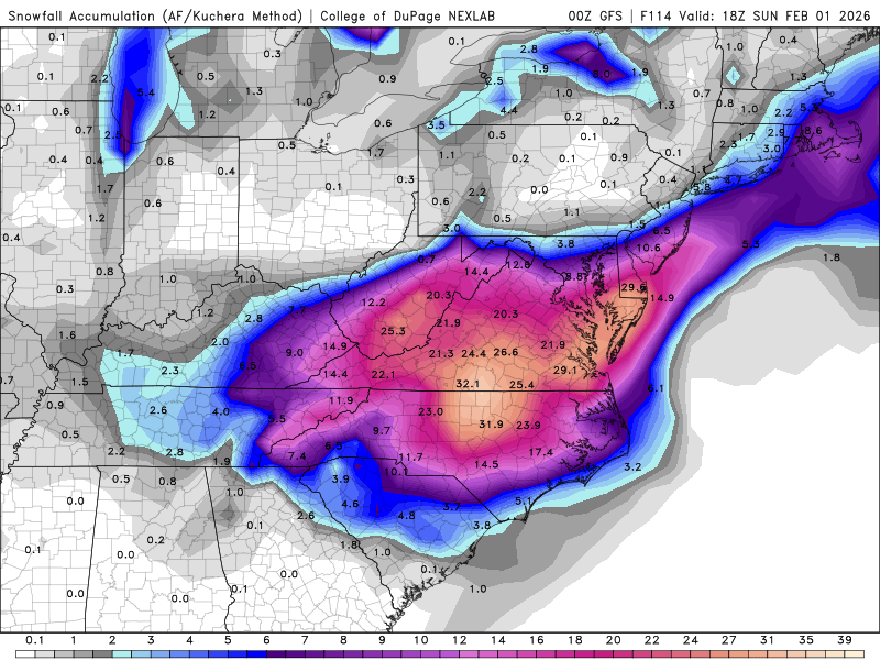
-
The Jan 31 Potential: Stormtracker Failure or 'Tracker Trouncing
Nomz replied to stormtracker's topic in Mid Atlantic
Talk about diffluence aloft out in front of that thing back to regularly scheduled programming -
The Jan 31 Potential: Stormtracker Failure or 'Tracker Trouncing
Nomz replied to stormtracker's topic in Mid Atlantic
fuck south carolina tbh -
The Jan 31 Potential: Stormtracker Failure or 'Tracker Trouncing
Nomz replied to stormtracker's topic in Mid Atlantic
bncho saying guys while stormtracker says folks says something about america tbh


