Lucy Pull
-
Posts
111 -
Joined
-
Last visited
Content Type
Profiles
Blogs
Forums
American Weather
Media Demo
Store
Gallery
Everything posted by Lucy Pull
-
The Jan 31 Potential: Stormtracker Failure or 'Tracker Trouncing
Lucy Pull replied to stormtracker's topic in Mid Atlantic
More confluence to the north this run. Saw this on the RGEM as well. -
Possible coastal storm centered on Feb 1 2026.
Lucy Pull replied to Typhoon Tip's topic in New England
Seems like for every positive influence there’s an equal or worse negative influence. -
The Jan 31 Potential: Stormtracker Failure or 'Tracker Trouncing
Lucy Pull replied to stormtracker's topic in Mid Atlantic
Yeah I agree. FV3 could’ve been interesting if it ran out further. consolidates energy in the western lobe of the ULL and starts tilting the trough negative. -
The Jan 31 Potential: Stormtracker Failure or 'Tracker Trouncing
Lucy Pull replied to stormtracker's topic in Mid Atlantic
No it’s not. I think youd want that further west to pump heights higher into the backside of our storms trough. Seems like its starting to fold the ridge over in its current position. Or you speed that up substantially and phase it into the backside of the trough. Could get a tug west from that. not at a good spot as depicted. -
The Jan 31 Potential: Stormtracker Failure or 'Tracker Trouncing
Lucy Pull replied to stormtracker's topic in Mid Atlantic
ULL not pushing as far west before swinging might outweigh any of the positives this run. Not consolidating energy west. -
The Jan 31 Potential: Stormtracker Failure or 'Tracker Trouncing
Lucy Pull replied to stormtracker's topic in Mid Atlantic
A few positives and negatives. Should be west from 6z IMO but east of 0z. higher height rise in front, more amplified western ridge, but ULL not pushing as far west before swinging. -
The Jan 31 Potential: Stormtracker Failure or 'Tracker Trouncing
Lucy Pull replied to stormtracker's topic in Mid Atlantic
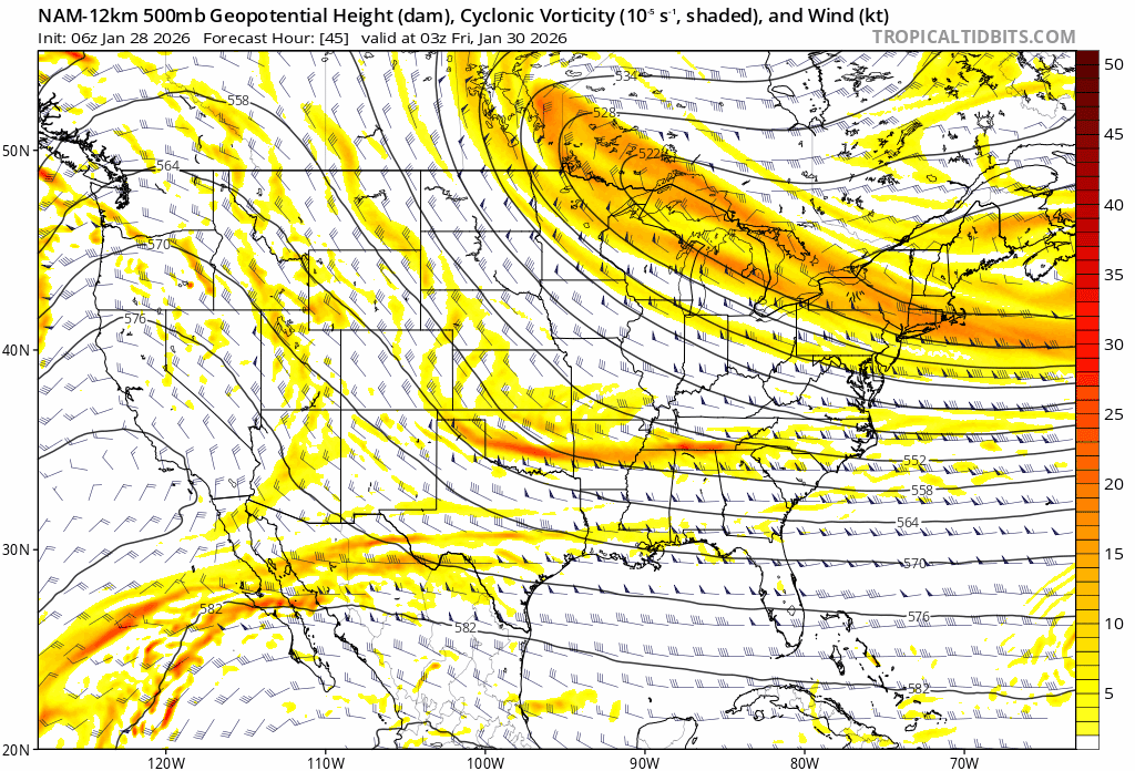
trend GIF from tidbits can be helpful for run to run trends.
-
E PA/NJ/DE Winter 2025-26 Obs/Discussion
Lucy Pull replied to LVblizzard's topic in Philadelphia Region
Too early to throw in the towel but leaning towards a scraper at most anywhere west of 95. Need to see some steady changes with confluence, the kicker, or the ULL backing west or north soon for anything appreciable. Still think Philly to NYC could be in a decent spot for some snows. Wouldn’t take much on euro or gfs. -
E PA/NJ/DE Winter 2025-26 Obs/Discussion
Lucy Pull replied to LVblizzard's topic in Philadelphia Region
Funnily enough based off some old screenshots it looks like the euro was showing a substantial hit around 168 hours. Same with GFS around 120 hours out. i remember them trending south and then NAM at 84hrs was the first to show a major hit north of the Mason Dixon again. Some screenshots leading up to event -


-
E PA/NJ/DE Winter 2025-26 Obs/Discussion
Lucy Pull replied to LVblizzard's topic in Philadelphia Region
Agree, delicate setup. Would like to see the ULL not dig as far south and trend negative a bit sooner. Climatologically speaking a storm of that magnitude as portrayed by the GFS in the South is extremely unlikely. Although anomalous setups can produce anomalous results. -
GFS further west with northern stream than euro and even its 6z at hr66. See if that translates as the run continues….
-
Yeah looks to be a midpoint solution between GFS and EURO operational. Long range NAM like you mentioned though.
-
CMC looking interesting at 102…biting more than 0z
-
GFS actually makes a pretty good recovery. Won’t be euro but looks like it will end up west of its 6z
-
January 25-26 Winter Storm Potential
Lucy Pull replied to Ralph Wiggum's topic in Philadelphia Region
Still mostly snow here south of blue mountain ski resort. Bigger flakes than earlier though. Looking like you should flip back to snow soon. -
Central PA Winter 25/26 Discussion and Obs
Lucy Pull replied to MAG5035's topic in Upstate New York/Pennsylvania
Crashing in central PA but still slightly rising in eastern. -
January 25-26 Winter Storm Potential
Lucy Pull replied to Ralph Wiggum's topic in Philadelphia Region
Starting to hear some louder “flakes” hit the windows here just south of Blue Mountain Ski Resort. Some larger flakes mixing in with the pixie dust as well. Think we may end up in a battle zone here. Correlation Coefficient showing the mix line starting to crash south in central PA again. edit: forgot to add observation. Just hit 9” here -
Central PA Winter 25/26 Discussion and Obs
Lucy Pull replied to MAG5035's topic in Upstate New York/Pennsylvania
Euro further south than GFS now with higher snow totals? That certainly wasn’t on my bingo card. -
January 25-26 Winter Storm Potential
Lucy Pull replied to Ralph Wiggum's topic in Philadelphia Region
With regard to north of 78 euro, gfs, and icon aren’t that far apart. -
January 25-26 Winter Storm Potential
Lucy Pull replied to Ralph Wiggum's topic in Philadelphia Region
Gfs still not really backing down slight shift north. -
Central PA Winter 25/26 Discussion and Obs
Lucy Pull replied to MAG5035's topic in Upstate New York/Pennsylvania
Anyone seeing RGEM anywhere? Doesn’t seem to be running on pivotal. -
January 25-26 Winter Storm Potential
Lucy Pull replied to Ralph Wiggum's topic in Philadelphia Region
Good news the ICON is a tic better. Bad news it’s the ICON. -
Central PA Winter 25/26 Discussion and Obs
Lucy Pull replied to MAG5035's topic in Upstate New York/Pennsylvania
FV3 still much colder than NAM. Sleet line further north than prior run though. -
Central PA Winter 25/26 Discussion and Obs
Lucy Pull replied to MAG5035's topic in Upstate New York/Pennsylvania
This run is like a hybrid of 12z and 18z. Stronger southern vort like 18z but less kinking back of heights as it gains latitude. Looks like it will be closer to 18z result though. -
Central PA Winter 25/26 Discussion and Obs
Lucy Pull replied to MAG5035's topic in Upstate New York/Pennsylvania
Hard for me to draw any conclusions either. Heights look higher in front but not sure if it’s just speeding up the southern vort a little bit. Would like that vort to be a little less amped though like 12z.