WeatherGeek2025
-
Posts
1,616 -
Joined
-
Last visited
Content Type
Profiles
Blogs
Forums
American Weather
Media Demo
Store
Gallery
Everything posted by WeatherGeek2025
-

Is we back? February discussion thread
WeatherGeek2025 replied to mahk_webstah's topic in New England
i'm back and we snow -
February 2026 OBS & Discussion
WeatherGeek2025 replied to Stormlover74's topic in New York City Metro
i'll leave for two weeks edit: if it does snow an inch you have give me a break -
February 2026 OBS & Discussion
WeatherGeek2025 replied to Stormlover74's topic in New York City Metro
nam shows nothing because it's a nothing model -
February 2026 OBS & Discussion
WeatherGeek2025 replied to Stormlover74's topic in New York City Metro
GFS, Euro AI (best computer model in the world) and Icon -
February 2026 OBS & Discussion
WeatherGeek2025 replied to Stormlover74's topic in New York City Metro
@Rjaycan we get the thread back after tonight's 0z runs? Wow great weekend coming nice little coating possible tonight and more Sunday night and I can stay up and track all weekend! Let's go guys -
February 2026 OBS & Discussion
WeatherGeek2025 replied to Stormlover74's topic in New York City Metro
can we get the thread back John? -
February 2026 OBS & Discussion
WeatherGeek2025 replied to Stormlover74's topic in New York City Metro
still time for this to trend north! i've seen this happen back in the day after a super bowl i forget the year NAM picked it up we got 8 inches in central park. Picked it up Friday, snowed monday -
February 2026 OBS & Discussion
WeatherGeek2025 replied to Stormlover74's topic in New York City Metro
does anyone have the euro ai ensembles clowmap -
February 2026 OBS & Discussion
WeatherGeek2025 replied to Stormlover74's topic in New York City Metro
hopefully the bermuda High pressure trends stronger bouncing the low pressure gradient north of where it's modeled and bringing us even heavier precipitation than Euro ai showing -
February 2026 OBS & Discussion
WeatherGeek2025 replied to Stormlover74's topic in New York City Metro
Euro AI again with the push north for Mondays event! Has it ever been wrong this close? -
Presidents' day Snow potential
WeatherGeek2025 replied to WeatherGeek2025's topic in New York City Metro
can we lock this thread guys. I won't make a thread until January 2027 i suck! -
February 2026 OBS & Discussion
WeatherGeek2025 replied to Stormlover74's topic in New York City Metro
cold morning 24 now -
Winter cancelled/uncancelled banter 25/26
WeatherGeek2025 replied to Rjay's topic in New York City Metro
I need more snow to be happy until next year! -
Presidents' day Snow potential
WeatherGeek2025 replied to WeatherGeek2025's topic in New York City Metro
can you put your profile picture back man, sorry but i don't like this one -
February 2026 OBS & Discussion
WeatherGeek2025 replied to Stormlover74's topic in New York City Metro
I am back guys and i made a thread for Presidents' day storm potential -
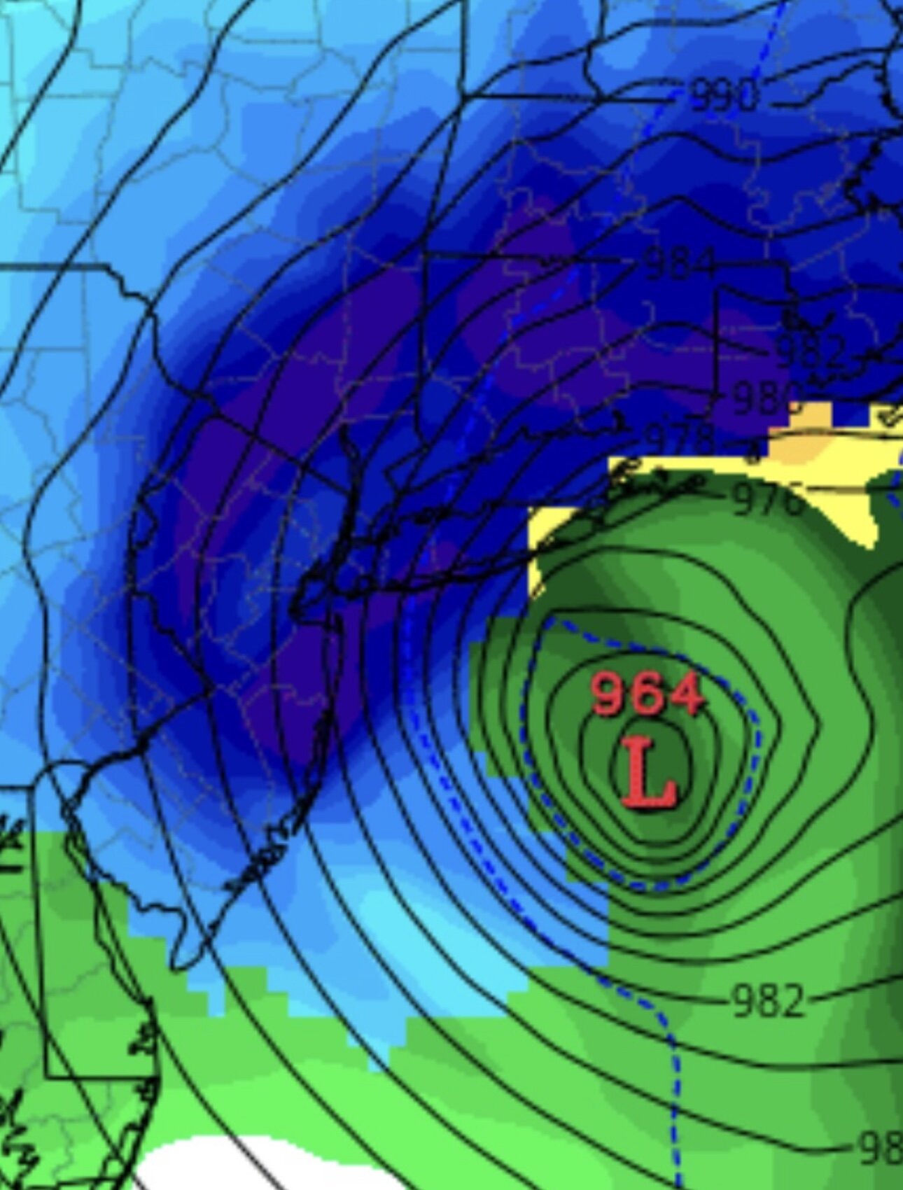
I am back and I figured we could open up a thread for this. I've been excited for this storm and I think that Bermuda High will essentially bring this storm to our latitude and go through a bombogenesis phase and give us a healthy snowstorm. Discuss away.
-
February 2026 OBS & Discussion
WeatherGeek2025 replied to Stormlover74's topic in New York City Metro
bye guys see you on the 14th -
Possible coastal storm centered on Feb 1 2026.
WeatherGeek2025 replied to Typhoon Tip's topic in New England
bye guys see you on the 14th! -
Snow Contest January 25th-26th
WeatherGeek2025 replied to WeatherGeek2025's topic in New York City Metro
oh okay i understand. -
Snow Contest January 25th-26th
WeatherGeek2025 replied to WeatherGeek2025's topic in New York City Metro
okay can we do a contest you start it Roger where we guess the snow Totals for Central Park for winter 2025-26. Winner gets $100 in bitcoin -
Winter cancelled/uncancelled banter 25/26
WeatherGeek2025 replied to Rjay's topic in New York City Metro
my cousin lives in Wilmington, NC they're supposed to get around 5-7 inches apparently -
cold morning stiff wind, 4 degrees to start
-
Winter cancelled/uncancelled banter 25/26
WeatherGeek2025 replied to Rjay's topic in New York City Metro
you're right my break starts tomorrow night, fair enough? -
-
Winter cancelled/uncancelled banter 25/26
WeatherGeek2025 replied to Rjay's topic in New York City Metro


