
BarryStantonGBP
-
Posts
786 -
Joined
-
Last visited
Content Type
Profiles
Blogs
Forums
American Weather
Media Demo
Store
Gallery
Everything posted by BarryStantonGBP
-

2025 Atlantic Hurricane Season
BarryStantonGBP replied to BarryStantonGBP's topic in Tropical Headquarters
In which sequence do they form -
2025 Atlantic Hurricane Season
BarryStantonGBP replied to BarryStantonGBP's topic in Tropical Headquarters
I translated them into NS -
2025 Atlantic Hurricane Season
BarryStantonGBP replied to BarryStantonGBP's topic in Tropical Headquarters
Thoughts on how I mapped how each NS might go? Anything you’d change? -
2025 Atlantic Hurricane Season
BarryStantonGBP replied to BarryStantonGBP's topic in Tropical Headquarters
TomballEd points out the possible "Erin" -
2025 Atlantic Hurricane Season
BarryStantonGBP replied to BarryStantonGBP's topic in Tropical Headquarters
I used the Euro models (weeklies/sub-seasonal range forecast) and somehow came up with: Dexter: 8-10 Aug, NW Gulf, C1 Erin: 12 - 16 Aug, EC FL swell, MDR, brush, C3 Fernand: 19 - 24 Aug, gyre NE Gulf, TS Gabs: 27 Aug - 2 Sep, Caribbean - NE Gulf, C2 Humberto: wait until September (or the very last day of August, probably CV long track), C4 I personally see 4 NS just based on the Euros alone Thoughts? -
2025 Atlantic Hurricane Season
BarryStantonGBP replied to BarryStantonGBP's topic in Tropical Headquarters
How many NS are predicting for august chap? -
2025 Atlantic Hurricane Season
BarryStantonGBP replied to BarryStantonGBP's topic in Tropical Headquarters
SAINT LEZAK HAS SPOKEN Tropical Development Windows Are Approaching Two Key LRC Predictions Are Already in the Forecast The next three weeks mark a critical transition in the tropics. As Saharan dust slowly retreats and the thunderstorm activity increases over the open Atlantic, Gulf, and Caribbean Sea, we are forecasting a much more favorable environment for tropical development. In fact, two of our key LRC-based tropical windows—predicted months ago—are expected to show up soon. These are not random guesses. These are precise forecast targets based on storm energy identified last fallthat is now cycling back through the pattern. As you’ll see in the graphic below, the timing and placement of these systems align directly with the Weather 20/20 LRC predictions that have been part of our Tropical Outlook Guide since spring. We’ll continue to track these windows closely in our daily updates and highlight what’s coming next a week from now in our early August Tropical Update next Saturday. Conclusion: A Quiet Start, But a Pattern-Driven Storm Season Awaits While the hurricane season has begun on a quiet note, we are not fooled by the calm—and you shouldn’t be either. The Saharan dust outbreaks and persistent summer anticyclone have done their job suppressing early activity, but the LRC tells a deeper story. We’re entering a new phase now—one where multiple tropical windows, renewed storm energy, and shifting jet stream dynamics begin to align. As we’ve shown throughout this report, the pattern is right on schedule. https://weather2020.substack.com/p/tropics-stay-quiet-impacts-from-saharan -
2025 Atlantic Hurricane Season
BarryStantonGBP replied to BarryStantonGBP's topic in Tropical Headquarters
this possibly could be the E storm based on the ECMWF probability models -
2025 Atlantic Hurricane Season
BarryStantonGBP replied to BarryStantonGBP's topic in Tropical Headquarters
it's 2017 again -
2025 Atlantic Hurricane Season
BarryStantonGBP replied to BarryStantonGBP's topic in Tropical Headquarters
atlantic about to go off https://charts.ecmwf.int/products/mofc_multi_tcyc_family_frequency?base_time=202507290000¶meter=Accumulated cyclone energy&valid_time=202509010000 -
2025 Atlantic Hurricane Season
BarryStantonGBP replied to BarryStantonGBP's topic in Tropical Headquarters
-
2025 Atlantic Hurricane Season
BarryStantonGBP replied to BarryStantonGBP's topic in Tropical Headquarters
tutt 2025-2025 lest we forget -
Central & Eastern Pacific Thread
BarryStantonGBP replied to Windspeed's topic in Tropical Headquarters
Central North Pacific (140°W to 180°) Tropical Weather Outlook (en Español*) 200 AM HST Tue Jul 29 2025 Hurricane Iona Satellite | Buoys | Grids | Storm Archive ...IONA STRENGTHENS INTO A MAJOR HURRICANE FAR SOUTH-SOUTHEAST OF THE HAWAIIAN ISLANDS... 11:00 PM HST Mon Jul 28 Location: 10.8°N 153.2°W Moving: W at 13 mph Min pressure: 964 mb Max sustained: 115 mph Public Advisory #9 1100 PM HST Forecast Advisory #9 0900 UTC Forecast Discussion #9 1100 PM HST Wind Speed Probabilities #9 0900 UTC Wind Speed Probabilities Arrival Time of Winds Wind History Warnings/Cone Interactive Map Warnings/Cone Static Images Warnings and Surface Wind Tropical Storm Keli Satellite | Buoys | Grids | Storm Archive ...KELI MOVING WESTWARD... 11:00 PM HST Mon Jul 28 Location: 12.5°N 146.6°W Moving: W at 12 mph Min pressure: 1006 mb Max sustained: 40 mph Public Advisory #4 1100 PM HST Forecast Advisory #4 0900 UTC Forecast Discussion #4 1100 PM HST Wind Speed Probabilities #4 0900 UTC Wind Speed Probabilities Arrival Time of Winds Wind History Warnings/Cone Interactive Map Warnings/Cone Static Images Warnings and Surface Wind -
2025 Atlantic Hurricane Season
BarryStantonGBP replied to BarryStantonGBP's topic in Tropical Headquarters
muh wavebreaking stfu wish that Eric guy with a room temp iq was here so I could challenge his views -
2025 Atlantic Hurricane Season
BarryStantonGBP replied to BarryStantonGBP's topic in Tropical Headquarters
clown take. Early September will be active -
2025 Atlantic Hurricane Season
BarryStantonGBP replied to BarryStantonGBP's topic in Tropical Headquarters
RIP -
2025 Atlantic Hurricane Season
BarryStantonGBP replied to BarryStantonGBP's topic in Tropical Headquarters
-
2025 Atlantic Hurricane Season
BarryStantonGBP replied to BarryStantonGBP's topic in Tropical Headquarters
humberto is on the atlantic naming list every 6 years so is barry, karen, melissa, lorenzo, imelda, etc of course people mention these names that’s how storm discussion works—especially preseason if you search “humberto,” you’ll mostly see the people who actually post forecasts and season outlooks that’s the whole point of having official names so unless we’re banning preseason discussion entirely, not sure what the conspiracy is supposed to be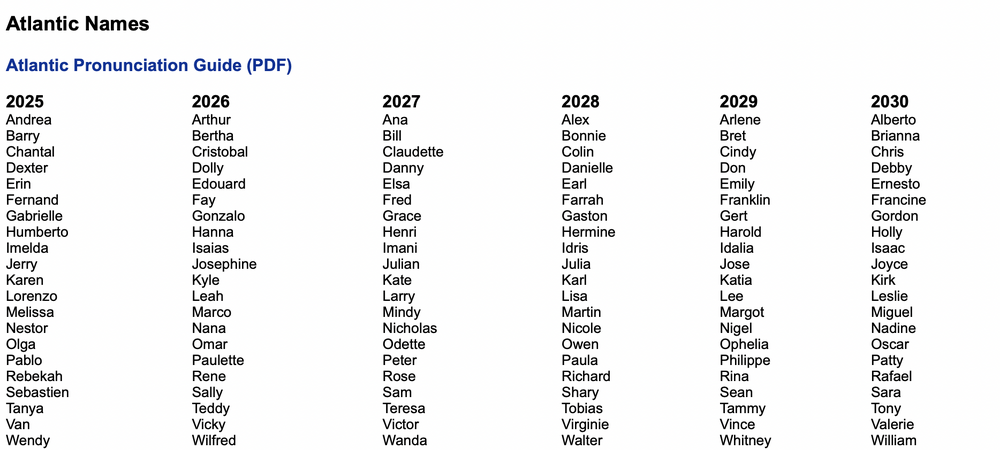
-
2025 Atlantic Hurricane Season
BarryStantonGBP replied to BarryStantonGBP's topic in Tropical Headquarters
can’t wait for the expose about the “melissa cabal” or the great “gabrielle syndicate” the nhc gave us a list, i’m using it see you all in 2031 when this thread is about how only 2 people ever mention “barry” and “karen” rinse, repeat so to be clear if someone mentions “humberto” more than once on a hurricane forum they must be the same person by that logic everyone who brings up “karen,” “melissa,” “lorenzo,” or “imelda” is running a deep op guys, the names come from a public list that repeats every 6 years next you’ll say i’m behind all the “katrina” mentions since 2005 let me know when talking about the actual storms is against the rules until then i’ll keep referencing the nhc’s schedule like every other weather nerd since 1979 -
2025 Atlantic Hurricane Season
BarryStantonGBP replied to BarryStantonGBP's topic in Tropical Headquarters
who? are we gonna pretend i invented the name humberto or that i’m the only one in this forum who ever mentions a hurricane name from the official NHC list y’all act like typing the same name a few times is some secret code reminder: humberto is literally a scheduled name on the rotating list every active poster brings up future names every single season searching the forum for any in-season name (karen, imelda, lorenzo, etc) will show “the same two or three” people posting the most—because they post the most about hurricane seasons also: not sure what the “proof” is here, unless there’s a rule against saying storm names out loud? not seeing how this is any different from the 500 posts about barry or melissa in the same threads also, i guess by this logic anyone who posted about dorian in 2019 or ian in 2022 is running a sockpuppet farm touch grass -
2025 Atlantic Hurricane Season
BarryStantonGBP replied to BarryStantonGBP's topic in Tropical Headquarters
Who? -
2025 Atlantic Hurricane Season
BarryStantonGBP replied to BarryStantonGBP's topic in Tropical Headquarters
Seems to be the new normal -
2025 Atlantic Hurricane Season
BarryStantonGBP replied to BarryStantonGBP's topic in Tropical Headquarters
A hurricane or TS will landfall somewhere in the Atlantic on September 7 hazelSODOFFton -
2025 Atlantic Hurricane Season
BarryStantonGBP replied to BarryStantonGBP's topic in Tropical Headquarters
Also Eric Webb can shut up i literally predicted a hurricane will landfall somewhere on the Atlantic on September 7th and another on the 25th -
2025 Atlantic Hurricane Season
BarryStantonGBP replied to BarryStantonGBP's topic in Tropical Headquarters


