.webp.70c18861c39c8ef8c4811e598978da45.webp)

CurlyHeadBarrett
-
Posts
827 -
Joined
-
Last visited
Content Type
Profiles
Blogs
Forums
American Weather
Media Demo
Store
Gallery
Posts posted by CurlyHeadBarrett
-
-
JFL, called it boyos


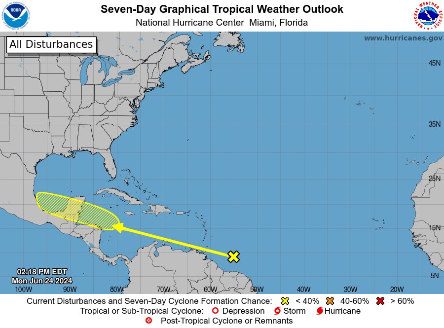
Tropical Weather Outlook
NWS National Hurricane Center Miami FL
800 PM EDT Tue Jun 25 2024For the North Atlantic...Caribbean Sea and the Gulf of Mexico:
1. Western Caribbean/Southwestern Gulf of Mexico (AL94):
A tropical wave located over the southeastern Caribbean Sea is
producing disorganized showers and thunderstorms as it moves quickly
westward at around 25 mph. Environmental conditions could become
more conducive for some gradual development late this week over the
western Caribbean Sea or over the southwestern Gulf of Mexico
during the weekend.
* Formation chance through 48 hours...low...10 percent.
* Formation chance through 7 days...low...20 percent.2. Eastern Tropical Atlantic:
A tropical wave centered a couple of hundred miles south of the
Cabo Verde Islands is producing disorganized showers and
thunderstorms. Some slow development of this system is possible
this weekend and into early next week while it moves generally
westward across the central and western tropical Atlantic at 15 to
20 mph.
* Formation chance through 48 hours...low...near 0 percent.
* Formation chance through 7 days...low...20 percent.
Forecaster Bucci -
1 minute ago, SnowenOutThere said:
This is amazing thank you.
Please see above for an updated glossary.
-
6 minutes ago, SnowenOutThere said:
As the only gen z here i think they might need some help understanding any brainrot terms.
I'll try and format them more nicely.
-
Mog = to outclass, e.g.:
- "2024 is definitely going to mog 2005"
- "The only season that 2025 is gonna mog is 2013"
- "Wow, Jova is such a mogger hurricane!"
- "Ian mogs Idalia to the utter depths of the Gulf of Mexico and back"
-
-maxx = to keep going at something and to max it out, e.g.:
- Idaliamaxx = to explode and hit the Gulf Coast,
- Otismaxx = to explosively intensify to a Category 5,
- Marcomaxx= to be be as tiny as possible,
- Olgamaxx = to be as short-lasting as possible,
- Freddymaxx = to get as much ACE as possible,
- Dorianmaxx = to stall/to rack up as high wind speeds as possible,
- Humbertomaxx = to try and reach peak intensity at the high latitudes as much as possible/to grow a long "tail" as much as possible
-
-cel = something really bad, e.g.:
- tropicalstormcel = a weak or ugly-looking tropical storm,
- hurricanecel = an ugly-looking hurricane,
- category2cel = a 110mph-peak hurricane that just failed to become a major hurricane (Sally is a PEAK example of a category2cel),
-
rizz = charisma e.g.:
- Idalia rizzing up the Gulf Coast
-
 3
3
-
Mog = to outclass, e.g.:
-
5 minutes ago, Tezeta said:
ok, so you know how prime jennifer grey just absolutely crushes today's stars like sydney sweeney?
She indeed mogs.
5 minutes ago, Tezeta said:IOW, she mogs them. turbomogs, actually.
To utter oblivion, to the depths of the Hollywood slums and back.
3 minutes ago, SnowenOutThere said:As the only gen z here i think they might need some help understanding any brainrot terms.
Please see here:
1 minute ago, CurlyHeadBarrett said:Oof, it's over. And god forbid what might happen in August and beyond, I don't wanna think about it.
How many named storms do you think we'll get and our first mogger (Cat 3+) storm/name?
Hopefully they'll 2023maxx (recurve out to sea).
I'm 28, so that young anymore, RIP
Mog = to outclass
-maxx = to keep going at something and to max it out, e.g.:
- Idaliamaxx = to explode and hit the Gulf Coast,
- Otismaxx = to explosively intensify to a Category 5,
- Marcomaxx= to be be as tiny as possible,
- Olgamaxx = to be as short-lasting as possible,
- Freddymaxx = to get as much ACE as possible,
- Dorianmaxx = to stall/to rack up as high wind speeds as possible,
- Humbertomaxx = to try and reach peak intensity at the high latitudes as much as possible/to grow a long "tail" as much as possible
-cel = something really bad (e.g. tropicalstormcel = a weak tropical storm)
Nope, not at all
Oh yes. Like Idalia rizzing up the Gulf Coast as an example.
Looking more like August, maybe?
I'm 28, so not Gen Z.
-
2
-
20 minutes ago, Jebman said:
It is possible this could be worse than the 2005 season. Ocean temps are way up and we have a developing Nina.
Oof, it's over. And god forbid what might happen in August and beyond, I don't wanna think about it.
How many named storms do you think we'll get and our first mogger (Cat 3+) storm/name?
20 minutes ago, Jebman said:However, I am hoping we will luck out and only see a few hurricanes, most of which recurve out to sea and hit no one else.
Hopefully they'll 2023maxx (recurve out to sea).
17 minutes ago, Floydbuster said:I am only 35 but my old school millennial self
I'm 28, so that young anymore, RIP
17 minutes ago, Floydbuster said:had no idea what mog meant.
Mog = to outclass
-maxx = to keep going at something and to max it out, e.g.:
- Idaliamaxx = to explode and hit the Gulf Coast,
- Otismaxx = to explosively intensify to a Category 5,
- Marcomaxx= to be be as tiny as possible,
- Olgamaxx = to be as short-lasting as possible,
- Freddymaxx = to get as much ACE as possible,
- Dorianmaxx = to stall/to rack up as high wind speeds as possible,
- Humbertomaxx = to try and reach peak intensity at the high latitudes as much as possible/to grow a long "tail" as much as possible
-cel = something really bad (e.g. tropicalstormcel = a weak tropical storm)
17 minutes ago, Floydbuster said:I thought maybe Major - something - something, like a weather acronym.
Nope, not at all
17 minutes ago, Floydbuster said:My teenage nephew taught me what the word rizz means though, so at least there is that.
Oh yes. Like Idalia rizzing up the Gulf Coast as an example.
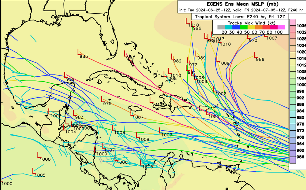
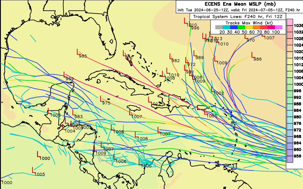
17 minutes ago, Floydbuster said:Looking at that image below, that is a remarkably favorable looking Atlantic for June 25th.

Looking more like August, maybe?
-
20 minutes ago, Jebman said:
It could turn out more mog than 1933,
That would be "it would mog harder than 1933"
20 minutes ago, Jebman said:if that was a bad season for tropical cyclones in the Atlantic/Caribbean.
Yeah 1933 was a turbomogger season.
https://en.wikipedia.org/wiki/1933_Atlantic_hurricane_season
259 ACE, 20-11-6
-
1
-
-
6 minutes ago, Jebman said:
Yeah I am 60, I got left behind a LOOOOOOOOOONG time ago lmao.
But, its really fun learning new expressions. For example, the 2024 Hurricane Season may very well mog out all the others going back to the 1920s.
Would it be over for 1933?
-
5 minutes ago, Jebman said:
Yep this hurricane season may mog all the others for the past 100 years.
Even 2005 and 2020?
-
14 minutes ago, Floydbuster said:
I am sorry what is mog?
Mog = to outclass
-
-
Just now, Floydbuster said:

Could this be the July major hurricane we surmised this spring was possible due to the warm sea surface temperatures?
Perhaps
The models are suggesting Beryl might unironically mog

-
think this will develop?


-
32 minutes ago, Ed, snow and hurricane fan said:
I'm not sure about whether the system that has a better chance to get named than the current invest (tracks w/o lows show what the ensembles predict for 94L, pretty meh) gets to Cat 3 or above. July Cat 3s are rare, but not unheard of. I use the word 'major', not 'mogger'.
Fair enough, I just prefer mogger for a cat 3+
32 minutes ago, Ed, snow and hurricane fan said:I think Dennis 19 years aqgo was the last US July major, I could be wrong, But I don't think I am.
Bertha 2008?
-
1 minute ago, Tezeta said:
these gen z hurricane kids are going to make me have to bust out the urban dictionary
I'm a millennial
-
 1
1
-
-
Just now, Ed, snow and hurricane fan said:
As noted, it isn't season cancel. Looking at the models, the wave coming off Africa could be a 1996 Bertha type system,, a rare July storm for ECUSA. Too early to get excited about something over a week away. It may have changed with the new and more active climatology, but June/July together used to average just over 1 named storm.
Follow the lead of GaWx abd WxWatcher, who do not post simply to post.
Wait
Beryl might be a mogger (cat 3+)?
-
25 minutes ago, GaWx said:
1. The SE Caribbean tropical wave has just been designated as Invest 94L fwiw.
2. The 12Z GEFS/GEPS have a rather strong signal for a TC impacting the Lesser Antilles ~7/1-3.
3. The 12Z Euro has no TC unlike the prior two runs.
It might be lifefuel for 94l

-
6 minutes ago, GaWx said:
The 12Z UKMET has nothing classified as a TC through the end of the run (day 7).
It’s over for tropicalcyclonecels.
wonder why this year had a rather slow start.
-
1 hour ago, WxWatcher007 said:
Probably early August. Anything sooner and that would be a blaring signal of a big season incoming.
What name do you think?
-
15 hours ago, Tezeta said:
This is what we are supposed to wake up for?
Never began anyway
ZCZC MIATWOAT ALL
TTAA00 KNHC DDHHMM

Tropical Weather Outlook
NWS National Hurricane Center Miami FL
800 AM EDT Tue Jun 25 2024

For the North Atlantic...Caribbean Sea and the Gulf of Mexico:

1. Western Caribbean/Southwestern Gulf of Mexico:
A westward-moving tropical wave located over the southeastern
Caribbean Sea is producing disorganized showers and thunderstorms.
Environmental conditions appear conducive for slow development once
the wave reaches the western Caribbean late this week.
* Formation chance through 48 hours...low...near 0 percent.
* Formation chance through 7 days...low...20 percent.


Forecaster Hagen/Pasch
-
4 hours ago, Maxwell03 said:
For now at least, it looks like it/they will struggle against early July climo
4 hours ago, Jebman said:It may be a notable September.
15 hours ago, Tezeta said:
This is what we are supposed to wake up for?
When do you think we will have our first moggercane (cat 3+)?
-
39 minutes ago, cptcatz said:
This is far more interesting to me than any typical June homegrown slop. If we're getting this kind of MDR signal in late June, what the hell is September gonna bring?
Total moggercanes.
-
2
-
-
57 minutes ago, Tezeta said:
This is what we are supposed to wake up for?
Yes bhai
-
56 minutes ago, Tezeta said:
zzz
wake up babe new wave just dropped
Tropical Weather Outlook
NWS National Hurricane Center Miami FL
200 PM EDT Mon Jun 24 2024
For the North Atlantic...Caribbean Sea and the Gulf of Mexico:
1. 1. Western Caribbean/Southwestern Gulf of Mexico:
A westward-moving tropical wave located a few hundred miles
east-southeast of the Windward Islands is producing disorganized
showers and thunderstorms. Environmental conditions appear
conducive for slow development once the wave reaches the western
Caribbean late this week.
* Formation chance through 48 hours...low...near 0 percent.
* Formation chance through 7 days...low...20 percent.
Forecaster Hagen/Pasch -
56 minutes ago, Tezeta said:
zzz
Sleeps me


2024 Atlantic Hurricane Season
in Tropical Headquarters
Posted
I'm also 28 pushing 29.
Do you know what mog means?
And here are the others:
How do you feel about these?