.webp.70c18861c39c8ef8c4811e598978da45.webp)

CurlyHeadBarrett
-
Posts
827 -
Joined
-
Last visited
Content Type
Profiles
Blogs
Forums
American Weather
Media Demo
Store
Gallery
Posts posted by CurlyHeadBarrett
-
-
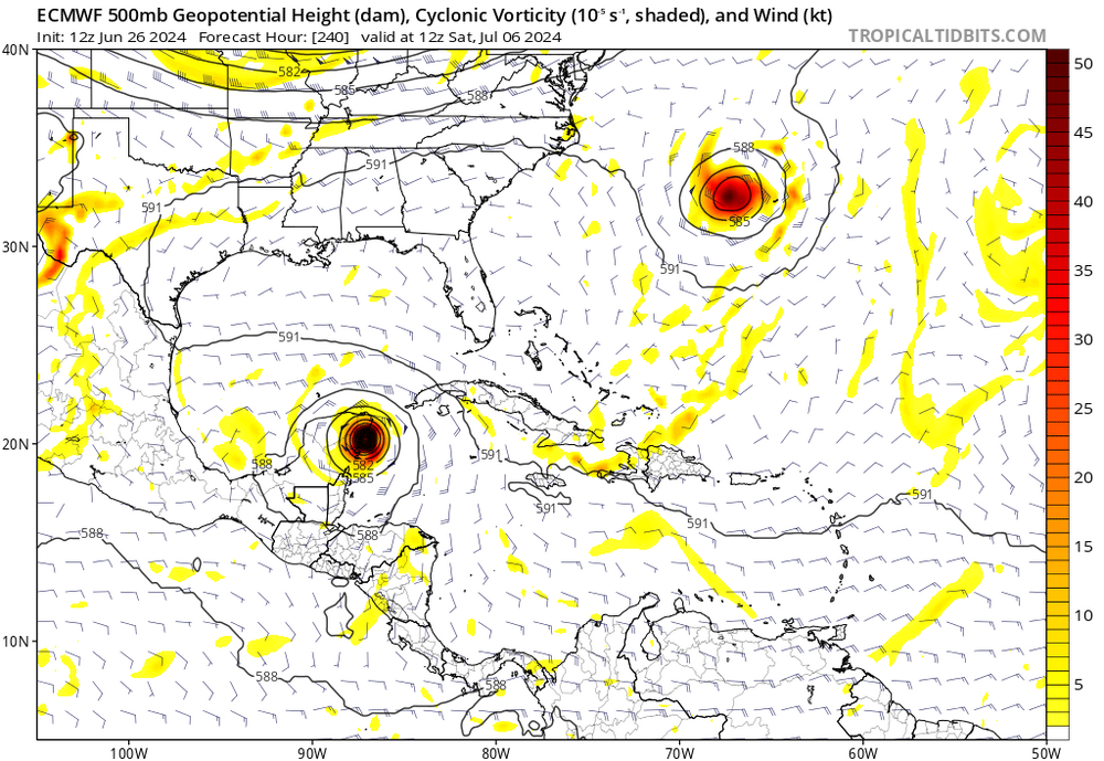
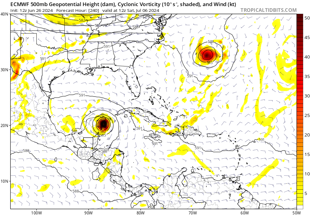
4 hours ago, Windspeed said:6 hours ago, GaWx said:The 0Z Euro still has a TC on a similar path to the 12Z but it isn’t as strong as the 12Z had, especially in the W Caribbean, where the 12Z had at least a cat 3. This is at most a cat 1 there. Regardless, it would still be pretty amazing in early July to have a TC not only survive the Caribbean but also strengthen into a (near) H as it crosses it!
I don't presently have access to compare, but yesterday's 12Z EURO had the ULL over the central GOM, which aided ventilation and built an ULAC right over the TC in the WCARIB. The GFS runs have all had the TUTT/ULL placed much further south and in closer proximity to the TC in WCARIB, which kept the TC under 20+ KTs of shear. Perhaps the new 00Z Euro came to a similar solution, hence a weaker system. Other than monitoring to see if we get a TC out of 95L, the evolution in modeling between the upper level features in the Caribbean is going to be the focus on any potential ceiling for intensity in the forecast. I do think 95L has an excellent shot of TCG and may become a strong TS, even a low-end hurricane, but I am very apprehensive of the major hurricane solutions that we may again see come and go over the next several days that would have any basis in reality. As has been repeated, the Caribbean in July is generally a graveyard for early MDR TCs for good reason. Climatology more often wins out this early in the season despite the above normal SSTs in place along potential track.
I’m regarding those recent mogger runs as tales from the Caribbean graveyard
until a solid td forms I need to see if it’s tales or not
I am doubtful
-
2 hours ago, Windspeed said:
Both initial runs of HAFS have a hurricane in the ECARIB. THE HAFS-B is the stronger of the two, reaching hurricane intensity prior to the Lesser Antilles. HAFS-A has a more asymmetrical sheared structure through the Windwards.
Hafs b is definitely reading tales from the Caribbean graveyard
sounds like a larp solution and not believable
-
3 hours ago, Floydbuster said:
HWRF shows a Category 3 strike on St. Vincent next Tuesday.

Larp/roblox solution imo
I am doubtful
-
5 hours ago, Jebman said:
We are all learning it. You are the turbomog of millennial slang!
I mog my fellow millennials to utter oblivion with zoomer slang
maybe because I ldar too much on the interwebs
-
 1
1
-
-
-
9 minutes ago, rclab said:
With no satellite or radar tracking the unknown was the greatest difference. We really never knew how bad it would be until it was on us. A later 1960 memory, during that active period, was leaving Brooklyn Technical High School during Hurricane Donna ( regular schedule no school cancellation or early dismissal ) and seeing the long stairs going up into Fort Green Park become a raging river. Today’s detailed Analysis of track and intensity of storms reduce the fear factor compared to then because we really never knew what was coming. I can still hear my mother telling me not to worry because we are only getting the ‘tail end’ of the hurricane. I was smart enough not to ask her what the hell that meant.
As always …..That sounds rough. It’s great to see how much things have improved for the better technologywise
-
1
-
-
11 minutes ago, rclab said:
Good evening CB. I became interested in my single digits during the early mid 50’s. The Daily News Coloroto Magazine would put out a color centerfold of the US with past hurricane tracks. In the actiive 50’s it was updated yearly. Most of the wiring was above ground. A candle supply was a necessity during those active seasons. I remember Riding in my father’s 1950 Buick Roadmaster and seeing many of my Brooklyn neighborhood side streets blocked by downed and crossed trees. I can’t even dream of coming close to the skills of my fellow forum members but I enjoy the spaghetti track graphics and the analysis that TS threads produce. Stay well, as always …
What would you say has changed then to now regarding the quality and intensity of hurricane landfalls?
i started tracking in 2009 but I live in Long Island so we don’t have too many guests
-
56 minutes ago, Jebman said:
I hope it never does. However the SSTs are high with a developing Nina. Its unfortunately a possibility this season.
I hope it never happens. I’m on edge especially since I tracked last year’s EPAC.
it’s so jova it if happens though but hopefully never in a million years
-
3 minutes ago, Jebman said:
If it is we are in serious trouble, Jova had 160mph sustained winds.
Storm like that smashing into the GoMex communities would be a catastrophe.
It would be jova for gomexcels
-
 1
1
-
-
5 minutes ago, Jebman said:
Is it August 26, or is it June 26?
August 26 in Minecraft
2 minutes ago, Jebman said:If it is we are in serious trouble, Jova had 160mph sustained winds.
Storm like that smashing into the GoMex communities would be a catastrophe.
Do you think it might happen one day?
-
9 minutes ago, Ed, snow and hurricane fan said:
2. Eastern Tropical Atlantic (AL95):
Satellite images indicate that a tropical wave located several
hundred miles southwest of the Cabo Verde Islands has become better
organized since yesterday with a more concentrated area of
thunderstorms.  Environmental conditions are forecast to be
unusually conducive for late June across the central and western
tropical Atlantic, and further development of this system is
anticipated.  A tropical depression or tropical storm could form
this weekend several hundred miles east of the Windward Islands
while the system moves westward at 15 to 20 mph.
* Formation chance through 48 hours...low...30 percent.
* Formation chance through 7 days...medium...60 percent.
It’s jova. Is 95L on cyclone HGH?
-
28 minutes ago, Floydbuster said:

2005 feels like yesterday. Now I DO feel old.
So do I
Can’t compete
23 minutes ago, Jebman said:It does look like it will be a very bad tropical season in the Atlantic and in the Caribbean/GoMex.
It’s jova.
-
17 minutes ago, Jebman said:
Giga-Mog
The Hernan Drago of hurricanes
13 minutes ago, Ed, snow and hurricane fan said:I could be crazy and say Dennis. But I won't.
Is Elsa an underestimate?
-
7 minutes ago, Ed, snow and hurricane fan said:
About 970 mb. I don't have a PPV model service which would show max wind.
Any possible analogs?
-
37 minutes ago, Ed, snow and hurricane fan said:
18Z GFS has a pretty MOGified TC into the Windward Islands.
Peak intensity?
-
38 minutes ago, SnowenOutThere said:
This was the post I was too cowardly to make
You gotta lowinhibmaxx
32 minutes ago, SnowenOutThere said:As someone in hs (yeah I still mog all of you in terms of gen zness) can confirm this is mainly hs terms
In real life I don’t talk like this haha
-
39 minutes ago, tiger_deF said:
The board would go nuts if this happened, two hurricanes in the Caribbean in early July

Beryl and Chris mog battle when
-
2 hours ago, tiger_deF said:
I’m still waiting until we can get a storm to Gaston-maxx. It’s been 8 years and I still haven’t let him go…

Ah, MoggerGaston
No one mogs like Gaston -
-
22 minutes ago, BYG Jacob said:
Euro shows the TUTT disappearing, which is why it is going crazy.
Don’t check SHIPS or the Euro
it’s jova for TUTTcels
-
Just now, Intensewind002 said:
Yeah kinda, I have a sister who is ten years younger than me and it seems like it’s more of a high school thing to actually talk like that. I mean some of my friends will use it in an ironic way though as a joke lol
Maybe I just rot too much
-
50 minutes ago, Ed, snow and hurricane fan said:
95L has been designated. Possible Caribbean threat next week.
Euro and ensembles are aggressive moving it into the Caribbean, GFS and ensembles less so, showing weakening. Post the images and model goodies here.
JFL AT THE SHIPS FORECAST THEY ARE SAYING BERYL MIGHT UNIRONICALLY BE A TERAMOGGER THIS IS CAGEFUEL
IT’S OVER


-
1
-
-
16 minutes ago, SRRTA22 said:
i never want to read the word rizz or skibidi on here ever again
unlucky
-
10 minutes ago, WxWatcher007 said:
Giga aggressive is a good way to put it, though I assume giga=uber for us olds

true. Or tera aggressive
10 minutes ago, WxWatcher007 said:I’m going to be skeptical of high end development with SAL and the graveyard lurking, but let’s see if this can organize in the next few days.
Ah yes the fluffy cloud reaper in the Caribbean awaits. We shall see
-
1
-


Hurricane Beryl - Hurricane Warning - Baffin Bay to San Luis Pass Texas
in Tropical Headquarters
Posted
it's so jova for the caribbean if this verifies