.webp.70c18861c39c8ef8c4811e598978da45.webp)

CurlyHeadBarrett
-
Posts
827 -
Joined
-
Last visited
Content Type
Profiles
Blogs
Forums
American Weather
Media Demo
Store
Gallery
Posts posted by CurlyHeadBarrett
-
-
5 minutes ago, Torch Tiger said:
Congrats Florida
It's over for Florida
-
 1
1
-
-
October looks like it may simply be a delayed September peak, and ensembles are going nuts right now and the GFS is definitely smelling the favorable MJO coming in.
-
 1
1
-
2
-
 2
2
-
 1
1
-
-
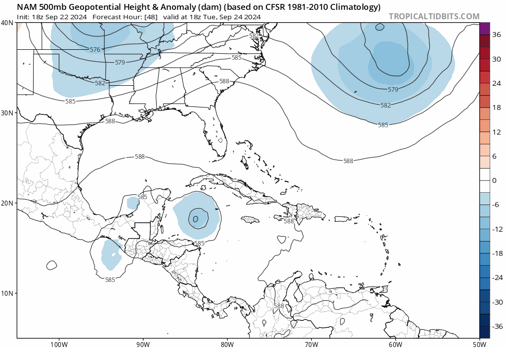
NAM model (good for large-scale features and 500MB steering)
-
1 minute ago, LongBeachSurfFreak said:
Yeah that’s still a giant mess regardless of how deep the convection is.
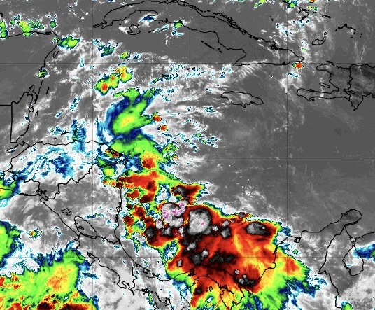
Satellite loop shows that a low lvl circulation is already going.
-
-
7 hours ago, PhiEaglesfan712 said:
First year la ninas that were misses
1970 (2nd year la nina 1971 was near average)
1973 (2nd year la nina 1974 was below average)
1983 (2nd year la nina 1984 was near average)
2007 (2nd year la nina 2008 was active)
And the 70s and 80s seasons were in a cold phase anyway
-
5 minutes ago, PhiEaglesfan712 said:
1st year tend to be hit and miss. However, the ones that are a hit tend to be hyperactive (1995, 2005, and 2020). 3rd year la ninas (there are only 4: 1956, 1976, 2000, and 2022) have all been underwhelming. Sometimes, a neutral season after 2 la nina years can be more active (think 2012, which was the third straight above average season).
Which ones are misses, and the best chance of an active season generally tends to be a 2nd year la nina?
-
Just now, PhiEaglesfan712 said:
2nd year la ninas tend to have above average hurricane seasons in the Atlantic. 2008, 2011, and 2021 are especially very good examples.
And what about 1st and 3rd year ninas?
I can see next year being a mogger season TBH, but what about hyperactive?
-
15 hours ago, GaWx said:
0Z:
Euro: E of 12Z, which had hit Mobile 9/29 at 989; 0Z hits Apalachicola 9/29 at 984 mb
GFS: just SE of Panama City late 9/27 at 979
CMC: E LA 9/27 981
ICON: C Gulf moving N 965 9/28
UK: 200 miles SSE of LA/TX border 1000 mb moving NNW late 9/27
next major will be called Humberto at this rate
-
On 9/20/2024 at 3:58 AM, Torch Tiger said:
Forget it. Most of us will be long long gone before the next major. sucks
next major will be called Humberto at this rate SMH
-
1
-
-
5 minutes ago, PhiEaglesfan712 said:
If we're going to be stuck in deep negative PDO, I really can't see anything else but a continued la nina.
What could that imply for hurricane season?
-
2 minutes ago, PhiEaglesfan712 said:
That's certainly possible. The thing with el ninos is that you can see them coming, but they can take years to develop. In the mid-2010s el nino, a lot of people were calling for it to happen in 2012-13, but didn't start to develop until 2014-15 and the super el nino happened in 2015-16.
The next el nino could happen in 2026-27, or it could happen in 2027-28. Whenever it happens, I think the PDO will have flipped to positive. Ideally, the subsurface will turn warm either by next summer or the summer of 2026.
And what do you predict for 2025-26?
-
19 hours ago, 40/70 Benchmark said:
Classic case of exaggerating the importance of a new tool or morcel of info...guy has been basing his entire analog composite on subsurface.
Frankly, I'm not really concerned with 2025-2026 ENSO at this point, but I will add that La Nina remaining modest decreases the likelihood of El Nino next year (delayed oscillation theory), which is probably related to the subsurface issue. It has utility, but I just think he is overreliant on it.
So when could be El Nino, 2026-27?
-
-
5 minutes ago, tiger_deF said:
Ironic that right as everyone is becoming bearish there’s finally something to actually look at. This seems a step beyond what many models had in terms of convective activity for today
 2 minutes ago, GaWx said:
For comparison, this is the 6Z GFS IR simulation as of 9AM EDT:

Bearish isn't the way to go tbh
-
 1
1
-
-
24 minutes ago, purduewx80 said:
It appears that way when you focus on operational runs, but the ensembles have been showing two camps for days, with other solutions somewhere in between. The Euro ensembles have had the most support for a slower/more westward track. As usual it comes down to where and when a surface low consolidates. There is also a lot of work to do with the upper pattern near the Gulf Coast, which is highly variable due to energy potentially undercutting the Upper Midwest ridging next week.
Which one mogs (is better) for invests and disturbances that haven't formed yet? Operational or ensembles?
-
2
-
-
4 minutes ago, GaWx said:
0Z EPS has an increase in members in the W GOM although a good number go earlier into the NE Gulf. Two camps.
What’s making them change all of a sudden
-
1 hour ago, Normandy said:
GFS is a goddam mess. No consistency (and I’m not faulting the model it’s just output is chaotic which might be indicative of the pattern).
42 minutes ago, GaWx said:0Z Euro: LLC forms eastern Bay of Campeche at 168 but moves and strengthens little through 240. At 240 it’s at 1002 mb with the entire Gulf having BN SLPs. Interestingly, a 2nd low (1004 mb) forms in the NE Gulf at the end.
Very fed up of no consistency
And fed up of the season
-
2 hours ago, yoda said:
At 993mb... so probably just a TS
It's Euro
-
1 hour ago, GaWx said:
I storms have been extra damaging and/or deadly on the CONUS since Irene of 1999 and Isabel of 2003. Afterward, there was Ivan of 2004, Ike of 2008, Irene of 2011, Isaac of 2012, Irma of 2017, Isaias of 2020, Ida of 2021, Ian of 2022, and Idalia of 2023.
Very damaging or deadly H storms for CONUS: Hazel of 1954, Hilda of 1964, Hugo of 1989, and Harvey of 2017.
I storms overall have been the worst by a good margin of any letter for the CONUS the last 25 years.
Humberto mogged hard in 2019
-
1
-
-
2 hours ago, TPAwx said:
Probably an H storm so for sure a miss in TB. We only take I storms seriously.
Hugo, Hortense, Harvey and Humberto
-
1
-
-
-
9 hours ago, Floydbuster said:
These kids born into the post-Katrina world are spoiled rotten.
I remember tracking Hurricane Season 2000 when I was a teenager. We didn't even heat up until late September with Hurricanes Isaac, Joyce and Keith. No hurricanes in July, let alone Category 5 storms. No hurricanes hit America in 2000 or 2001.
The U.S. saw no hurricane landfalls between the day after my 11th birthday (Irene, 1999) and a week and a half before my 14th birthday (Lili, 2002). When you are a teenager tracking hurricanes, 11 to 14 years old is a long time. I had plenty of Caribbean action like Keith, Iris and Michelle...but no hurricanes between Irene and Lili for the U.S. coastline.
These kids have had three hurricanes strike America within a few weeks, and they still cry. I feel like an old grump.
OK unc
-
1 hour ago, MANDA said:
For informational purposes only.
Every basin in the Northern Hemisphere is now below normal by all metrics.
We've just started the "3rd. Quarter" so still time for anything in the Atlantic basin. MJO forecast much more favorable later next week into first half of October so we're poised to make up some ground. Will it be enough ground to make it a hyperactive season? Likely not.
Another 1 or 2 quality hits could make it very memorable though. That is on the table.
Anyone still thinking we get 20+ names?

20 names in 2025
-
1
-


2024 Atlantic Hurricane Season
in Tropical Headquarters
Posted
https://i.imgur.com/5BRjzFy.mp4
Long-range GFS