.webp.70c18861c39c8ef8c4811e598978da45.webp)

CurlyHeadBarrett
-
Posts
827 -
Joined
-
Last visited
Content Type
Profiles
Blogs
Forums
American Weather
Media Demo
Store
Gallery
Posts posted by CurlyHeadBarrett
-
-
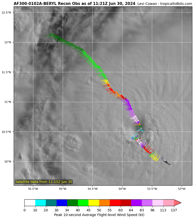
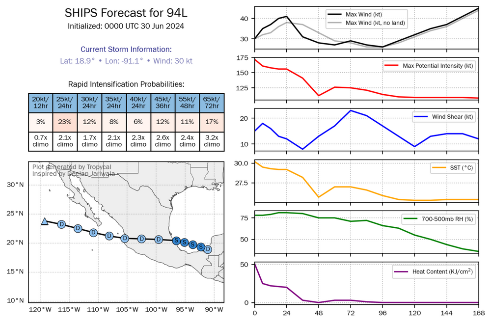
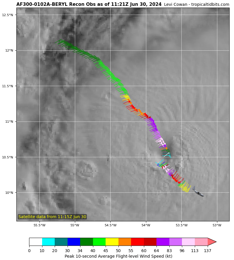
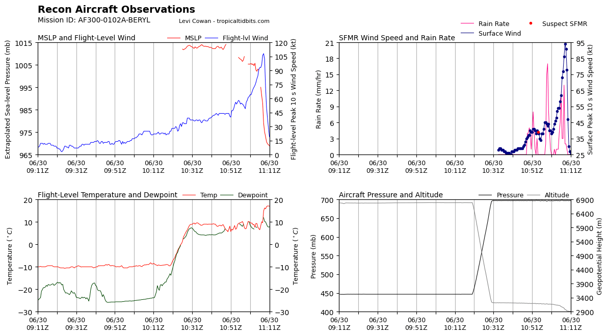
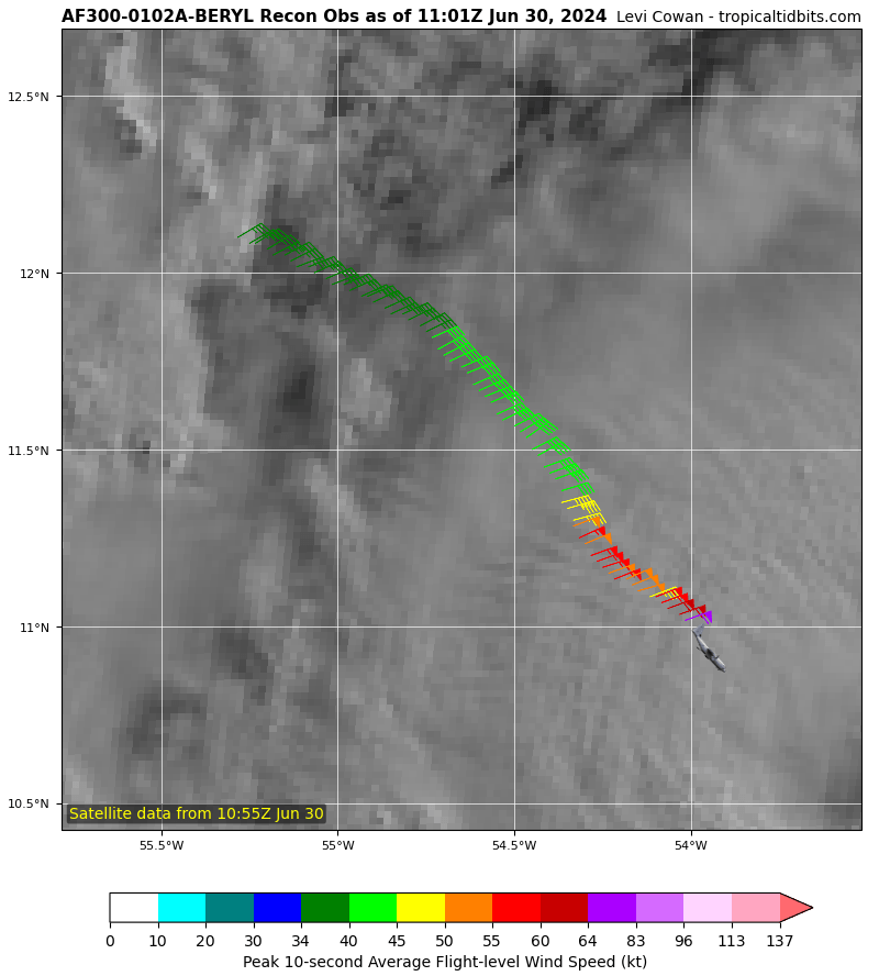
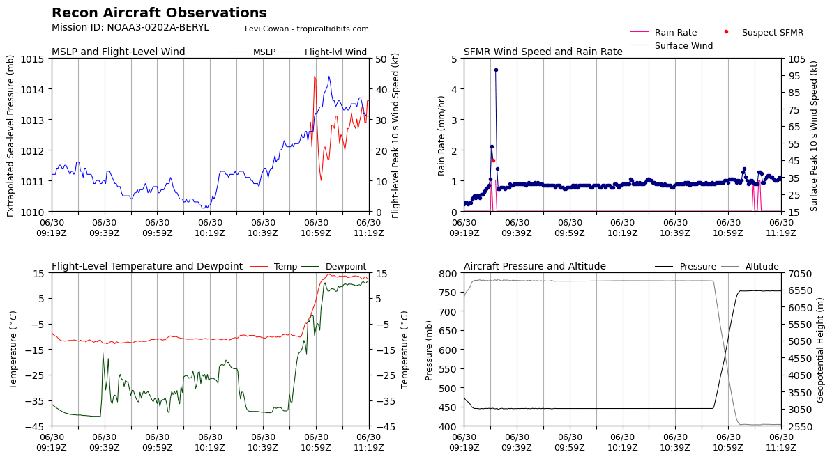
Peak Flight-Level Winds: 108kt at 11:08z
Peak SFMR: 94kt at 11:08z Minimum Extrap. Pressure: 968.7mb at 11:12z -
It’s over
pack it up boys
-
Didn’t reach the eyewall jfl
108 KT FL 94KT SFMR


-
-
1 hour ago, Jebman said:
That track is serious. If it verifies, Beryl will hit MY backyard.
Hopefully she does not.
-
1 minute ago, BlunderStorm said:
Just look at Beryl intensify on IR.Gyatt what a mogger. primed for RI
-
 1
1
-
 1
1
-
-
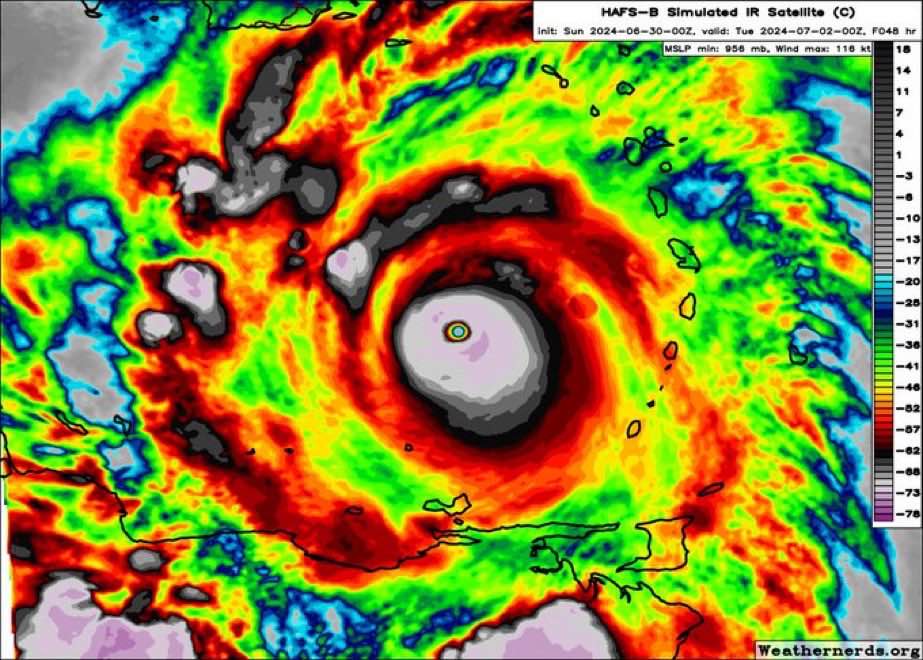
Gyatt this is brootal from HAFS B
-
 1
1
-
2
-
-
Just now, Ed, snow and hurricane fan said:
If this storm does wind up like some of the globals suggest, a US threat in the long range, the thread might get busy enough for storm mode, and some of the random posts or arguments over CC might get deleted.
cc?
-
54 minutes ago, Boston Bulldog said:
As an older Gen Z myself, can confirm I have a vague idea about what they're saying
thank YOU bhai
54 minutes ago, Boston Bulldog said:but can also confirm only the deepest corners of brainrot internet speak like this.
do you think I am a permarotter jfl
54 minutes ago, Boston Bulldog said:Get ready to learn Barrettese buddy, or maybe just touch grass.
YES! Also mirin the term Barrettese
54 minutes ago, Boston Bulldog said:Not quite sure what declaring everything "Joever" does for the overall discussion (it does make the thread a bit unreadable) but I do appreciate the enthusiasm for the field. We all end up on this site for the same reasons.
joever/jova means “over”
54 minutes ago, Boston Bulldog said:Regardless, what a show put on so far by Beryl so far. I am glad the medium term outlook beyond initial impacts in the Lesser Antilles is getting more shine on here. Shear awaits, and unfortunately it will impact the system after the Windwards. There is a cap on what the storm can do down the line, it's so difficult to have a Caribbean Cruiser thread the needle, especially in early July. My only pause is that the NHC forecast seems to be flaunting climatology towards the tail end of their forecast, though it makes total sense to not forecast rapid weakening at 96-120 hours. It's foolish to stamp your name on an RI forecast that far out, equally so to do the same for rapid weakening outside of the high latitudes.
What do you think is the maximum possible peak for Beryl?
-
18 minutes ago, SnowenOutThere said:
Global warming deserves to put people in hysterics. Have you seen the ssts that are under beryl right now? I’d have to wager they are probably playing a significant role in the current rapid intensification going on.
This.
-
45 minutes ago, Silver Meteor said:
global warming hysteria.
?
-
17 minutes ago, Jebman said:
This is going to be so Jova for the entire Caribbeancels and the entire GoMexcels. Its so hard to believe this is still only late JUNE!
EXACTLY. And gandy forbid what’s going to come in July, August and September
-
-
1 minute ago, WxWatcher007 said:
Beryl has a chance to really go to town in the next 24-36 hours. Folks in the islands need to be prepared for a significant hit.
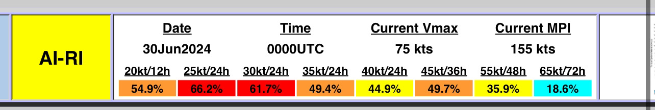
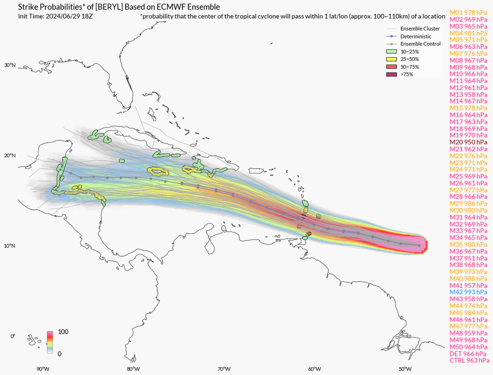
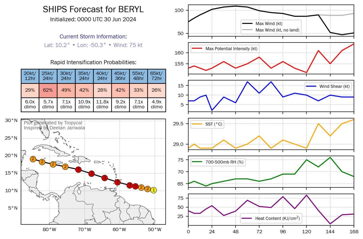
Hurricane Beryl Discussion Number   6
NWS National Hurricane Center Miami FL       AL022024
1100 PM AST Sat Jun 29 2024

Beryl continues to strengthen rapidly this evening. Cold convective
cloud tops between -70 to -80 C are now wrapping fully around the
center after earlier being confined to its southern semicircle.
After the prior advisory, a late arriving SSMIS microwave pass
revealed a small closed eyewall now exists. The latest subjective
and objective intensity estimates range between 65 to 80 kt and
based on the continued improved structure on satellite imagery, the
intensity is set at 75 kt, towards the upper end of those estimates.
As earlier mentioned, both the NOAA and Air Force Reserve Hurricane
Hunters will investigate Beryl tomorrow morning, which will provide
our first in-situ data to assess the hurricane.

Beryl has maintained a just north of due west fast motion this
evening, estimated at 280/17 kt. An extensive mid-level ridge
remains positioned poleward of the hurricane, and Beryl should
maintain a westward to west-northwestward motion at a similar speed
over the next couple of days. This track will take the hurricane
over the Windward Islands overnight on Sunday into Monday. A subtle
weakness in this ridging in the 24-48 hour period should help the
hurricane gain a bit of latitude before the ridge builds back in
over the southeastern U.S. by the middle of next week, likely
resulting in a turn back more westward by the end of the forecast
period. The NHC forecast track is just a touch left and slower
compared to the prior advisory, but remains very close to a blend of
the consensus aids HCCA and TVCN.

Unfortunately Beryl has all the ingredients favorable for continued
rapid intensification in the short-term. The light to moderate
easterly shear that had been affecting the system is subsiding,
while the hurricane remains embedded in a large area of deep-layer
moisture and over 28-29 C sea-surface temperatures. The small and
well-organized inner core likely means the hurricane should take
full advantage of these pristine conditions, and both the GFS and
ECMWF versions of SHIPS-RII show rapid intensification indices 7 to
10 times above climatology. Thus, the latest NHC intensity forecast
will explicitly show rapid intensification over the next day, making
Beryl a very dangerous Category 3 hurricane before it moves across
the Windward islands by tomorrow night. Once Beryl enters the
Caribbean, there could be a marked increase in westerly vertical
wind shear as a strong easterly low-level jet, common for this time
of year in the eastern Caribbean Sea, will keep Beryl moving quickly
westward against lighter upper-level upper-level easterlies
partially eroded by a deep-layer trough off the Eastern Seaboard.
Thus some weakening is forecast after 48 hours as Beryl moves
further into the Caribbean. The NHC intensity forecast remains close
to the reliable consensus aids and now shows a peak intensity of 110
kt in 36 hours, though a few of the regional-hurricane models do
peak Beryl stronger than shown here.


Key Messages:

1. Beryl is expected to be a dangerous major hurricane when it
reaches the Windward Islands late Sunday night or Monday, bringing
destructive hurricane-force winds and life-threatening storm surge.
Hurricane Warnings are in effect for much of the Windward Islands.

2. Heavy rainfall and localized flooding is expected across the
Windward Islands Sunday night and Monday.

3. Interests in the central and western Caribbean should monitor the
progress of this system.  Users are reminded that there is large
uncertainty at days 4 and 5 and to not focus on the specific details
of the track or intensity forecast.


FORECAST POSITIONS AND MAX WINDS

INIT  30/0300Z 10.4N  51.2W   75 KT  85 MPH
 12H  30/1200Z 10.8N  53.7W   90 KT 105 MPH
 24H  01/0000Z 11.5N  57.0W  105 KT 120 MPH
 36H  01/1200Z 12.3N  60.4W  110 KT 125 MPH
 48H  02/0000Z 13.4N  64.0W  110 KT 125 MPH
 60H  02/1200Z 14.6N  67.6W  105 KT 120 MPH
 72H  03/0000Z 15.6N  71.7W  100 KT 115 MPH
 96H  04/0000Z 17.0N  78.9W   85 KT 100 MPH
120H  05/0000Z 18.5N  85.0W   75 KT  85 MPH

$$
Forecaster Papin
sheeit this sounds ROUGH ngl
Unfortunately Beryl has all the ingredients favorable for continued
rapid intensification in the short-term. The light to moderate
easterly shear that had been affecting the system is subsiding,
while the hurricane remains embedded in a large area of deep-layer
moisture and over 28-29 C sea-surface temperatures. The small and
well-organized inner core likely means the hurricane should take
full advantage of these pristine conditions, and both the GFS and
ECMWF versions of SHIPS-RII show rapid intensification indices 7 to
10 times above climatology. Thus, the latest NHC intensity forecast
will explicitly show rapid intensification over the next day, making
Beryl a very dangerous Category 3 hurricane before it moves across
the Windward islands by tomorrow night. Once Beryl enters the
Caribbean, there could be a marked increase in westerly vertical
wind shear as a strong easterly low-level jet, common for this time
of year in the eastern Caribbean Sea, will keep Beryl moving quickly
westward against lighter upper-level upper-level easterlies
partially eroded by a deep-layer trough off the Eastern Seaboard.
Thus some weakening is forecast after 48 hours as Beryl moves
further into the Caribbean. The NHC intensity forecast remains close
to the reliable consensus aids and now shows a peak intensity of 110
kt in 36 hours, though a few of the regional-hurricane models do
peak Beryl stronger than shown here.
-
-
 94l might actually luck out jfl
-

..BERYL STILL RAPIDLY INTENSIFYING... ...EXPECTED TO BRING LIFE-THREATENING WINDS AND STORM SURGE TO THE WINDWARD ISLANDS AS A MAJOR HURRICANE...
FORECAST POSITIONS AND MAX WINDS

INIT  30/0300Z 10.4N  51.2W   75 KT  85 MPH
 12H  30/1200Z 10.8N  53.7W   90 KT 105 MPH
 24H  01/0000Z 11.5N  57.0W  105 KT 120 MPH
 36H  01/1200Z 12.3N  60.4W  110 KT 125 MPH
 48H  02/0000Z 13.4N  64.0W  110 KT 125 MPH
 60H  02/1200Z 14.6N  67.6W  105 KT 120 MPH
 72H  03/0000Z 15.6N  71.7W  100 KT 115 MPH
 96H  04/0000Z 17.0N  78.9W   85 KT 100 MPH
120H  05/0000Z 18.5N  85.0W   75 KT  85 MPH

$$
Forecaster Papin
-
1
-
-
24 minutes ago, nvck said:
You gotta be like hella online either tiktok or 4chan or maybe twitter to fully comprehend
I have been online since the AOL days
-
20% CHANCE TO TURN INTO A CATEGORY 5. IT'S SO JOVA FOR SAINTVINCENTCELS AND BARBADOSCELS

-
16 minutes ago, CheeselandSkies said:
That was like when Typhoon Manghkut broke the HWRF as the model turned it into Earth's version of the Great Red Spot; 777mb, >300kt.
Great red spot mogs Mahghkut to death
-
1
-
-
-
11 minutes ago, Ed, snow and hurricane fan said:
I'm on the Boomer/Gen X cusp, and I don't understand it all. he asks good questions.
Thank you bhai.
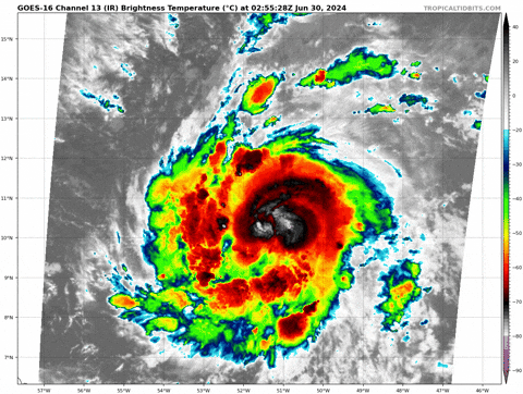
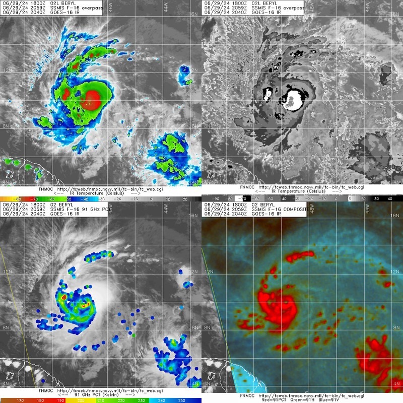
11 minutes ago, Ed, snow and hurricane fan said:CIMMS automatic Dvorak is impressed. Eye almost closed.
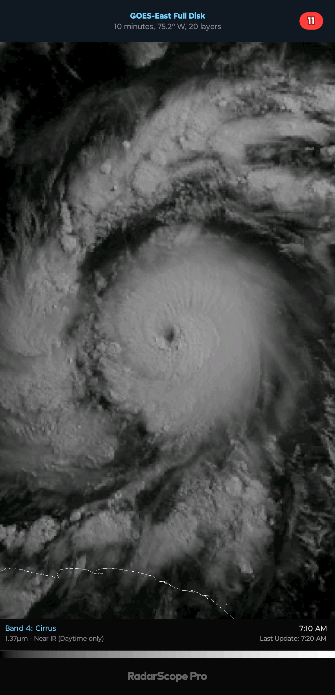
 Date :  29 JUN 2024    Time :   221021 UTC
      Lat :   10:09:08 N     Lon :   49:37:37 W


             Final T#  Adj T#  Raw T#
                4.4     4.4     4.3

 Center Temp : -71.7C    Cloud Region Temp : -70.1C

 Scene Type : UNIFORM CDO CLOUD REGION w/ MW EYE
What's the max Dvorak you think Beryl would peak at?
-
Just now, Maxwell03 said:
Ditto call it a cusper because I would not attribute that speech to millennials
1995 is a cusper?
-
7 minutes ago, Jebman said:
Barrett is just saying in millennialspeak, that if Beryl keeps on intensifying like she is and if she strikes the GoM, it will be extremely bad for everyone on the coast all along the GoM. VERY extremely bad. He is also saying that there were no major hurricanes to hit the Lesser Antilles in the past ~ 170 years or so. That was what Barrett meant when he remarked, Not a molecule.
I love millennialspeak, and I am a late baby boomer lmao
Well, baby boomer/Gen X cusp, I guess
Correct.
Also not a molecule means nada in this case

Hurricane Beryl - Hurricane Warning - Baffin Bay to San Luis Pass Texas
in Tropical Headquarters
Posted
PACK IT UP LADS IT’S OVER FOR THR CARIBBEAN
Location: 10.6°N 53.9°W
Moving: W at 21 mph
Min pressure: 968 mb
Max sustained: 100 mph