.webp.70c18861c39c8ef8c4811e598978da45.webp)

CurlyHeadBarrett
-
Posts
827 -
Joined
-
Last visited
Content Type
Profiles
Blogs
Forums
American Weather
Media Demo
Store
Gallery
Posts posted by CurlyHeadBarrett
-
-
5 hours ago, Boston Bulldog said:
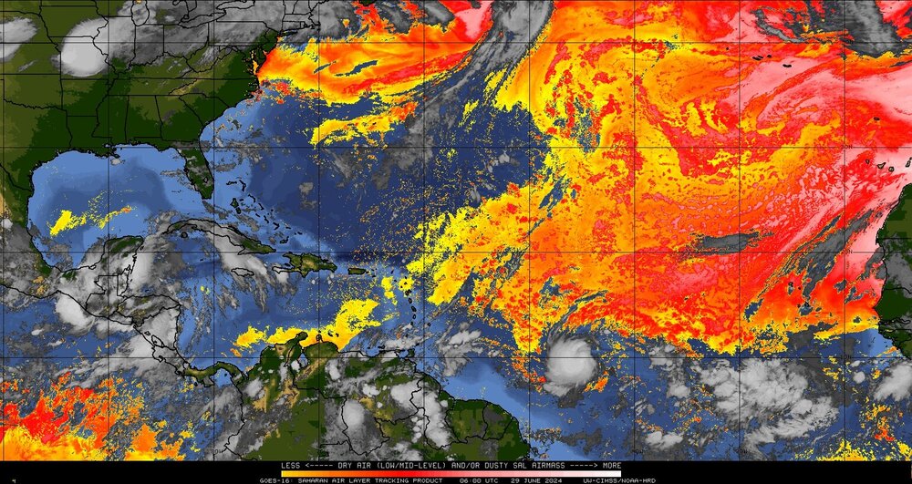
I would attribute the lack of banding structures to Beryl's young age AND the prominence of the Saharan Air Layer nearby. Hard to expand a moist convective envelope when the desert is a few kilometers away to the north. The MDR is dry, but favorable. There isn't much of a mechanism to push this SAL into the system...yet. If there was one thing that can stop this system from achieving the lofty heights the models currently show, it's the Saharan Dust in tandem with quickening easterlies. 96L may have less of it to deal with if Beryl takes a gulp of it...
Beryl might unironically mog the SAL
-
2 hours ago, Floydbuster said:
Good morning Beryl.

Beryl: Good morning, do I mog?
-
 1
1
-
-
Just now, WxWatcher007 said:
Officially Beryl now
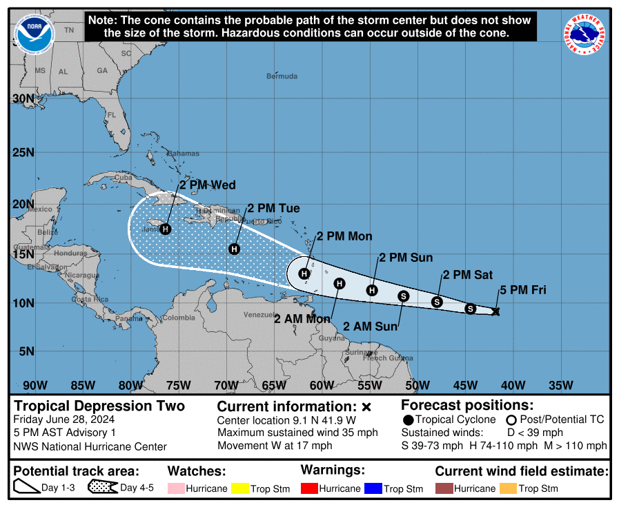
mogs me ngl

FORECAST POSITIONS AND MAX WINDS

INIT  29/0300Z  9.3N  43.6W   35 KT  40 MPH
 12H  29/1200Z  9.7N  46.2W   40 KT  45 MPH
 24H  30/0000Z 10.4N  49.7W   50 KT  60 MPH
 36H  30/1200Z 11.0N  53.1W   60 KT  70 MPH
 48H  01/0000Z 11.7N  56.5W   70 KT  80 MPH
 60H  01/1200Z 12.5N  60.0W   80 KT  90 MPH
 72H  02/0000Z 13.6N  63.6W   90 KT 105 MPH
 96H  03/0000Z 16.0N  71.0W   90 KT 105 MPH
120H  04/0000Z 17.8N  77.8W   80 KT  90 MPH

$$
Forecaster Kelly
-
19 minutes ago, Ed, snow and hurricane fan said:
AL, 02, 2024062900, , BEST, 0, 92N, 427W, 35, 1006, TS, 34, NEQ, 40, 0, 0, 40, 1011, 150, 40, 45, 0, L, 0, , 0, 0, BERYL, M, 0, , 0, 0, 0, 0, genesis-num, 008,
What a mogger
...DEPRESSION STRENGTHENS INTO TROPICAL STORM BERYL...
...EXPECTED TO STRENGTHEN INTO A HURRICANE AS IT APPROACHES THE
WINDWARD ISLANDS...
SUMMARY OF 1100 PM AST...0300 UTC...INFORMATION
-----------------------------------------------
LOCATION...9.3N 43.6W
ABOUT 1110 MI...1785 KM ESE OF BARBADOS
MAXIMUM SUSTAINED WINDS...40 MPH...65 KM/H
PRESENT MOVEMENT...W OR 275 DEGREES AT 18 MPH...30 KM/H
MINIMUM CENTRAL PRESSURE...1006 MB...29.71 INCHES -
41 minutes ago, Ed, snow and hurricane fan said:
2 oranges and a TD well on its way to Beryl. And it is June.
Ouch
-
2 minutes ago, WxWatcher007 said:
Given the improving presentation this looks like a tropical storm and if this organization continues hurricane watches will certainly be warranted at 11pm.
2 minutes ago, andyhb said: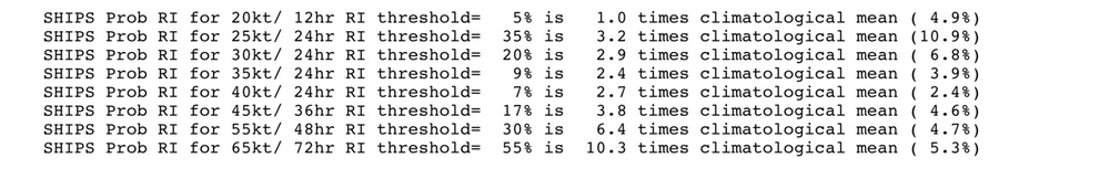
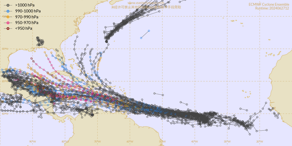
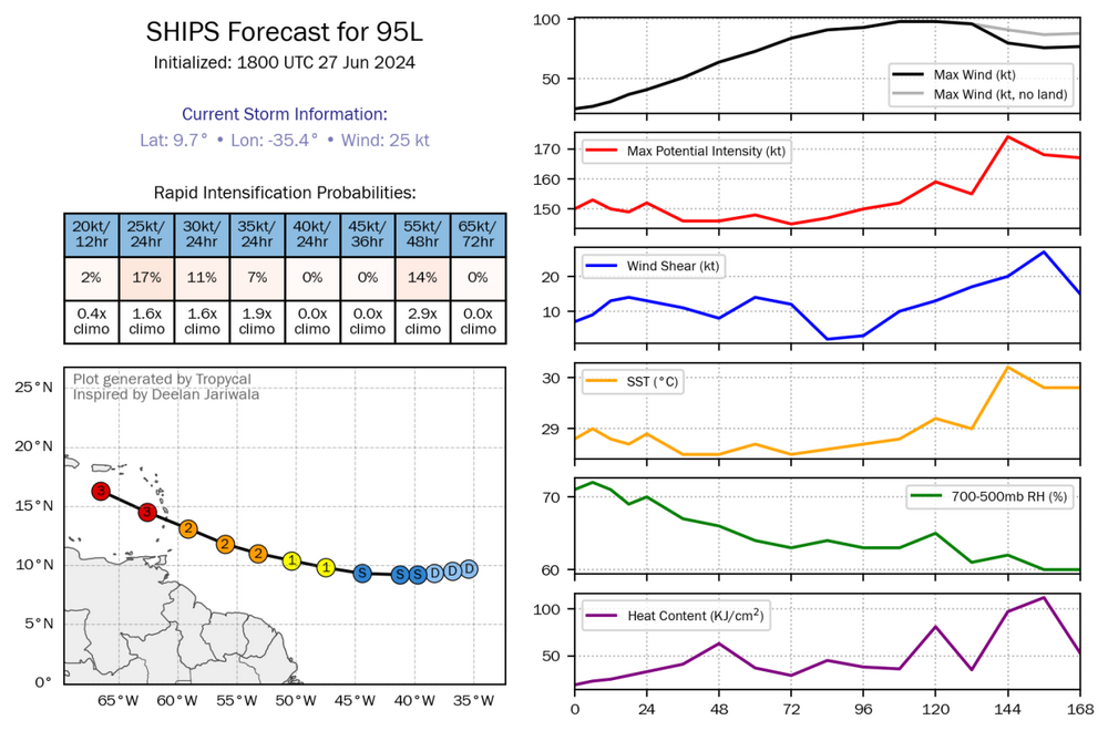
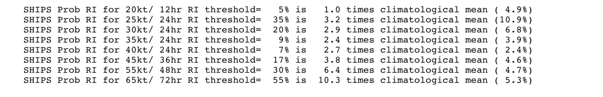
New SHIPS run continues with amazingly high probabilities of RI for this region this early in the season, especially the 65 kt/72 hour threshold. Can't be stressed enough that this part of the Atlantic and Caribbean is usually where TCs go to die this early in the year.
JFL at TROPICAL TIDBITS
Tropical Storm BERYL
As of 00:00 UTC Jun 29, 2024:
Location: 9.2°N 42.7°W
Maximum Winds: 35 kt Gusts: N/A
Minimum Central Pressure: 1006 mb
Environmental Pressure: N/A
Radius of Circulation: N/A
Radius of Maximum wind: 40 nm
34 kt Wind Radii by Quadrant:AL, 02, 2024062900, , BEST, 0, 92N, 427W, 35, 1006, TS, 34, NEQ, 40, 0, 0, 40, 1011, 150, 40, 0, 0, L, 0, , 0, 0, BERYL, M, 0, , 0, 0, 0, 0, genesis-num, 008,
-
 1
1
-
-
Dennis and Emily first official forecast for comparison
-
1
-
-
uptrending
mogger alert
-
52 minutes ago, andyhb said:
This cane season is really going to go to hell in a hand-basket, isn't it...
too many hurricanes on hurricane HGH and doing the hurricane equivalent of bonesmashing and mewing
-
18 minutes ago, Ed, snow and hurricane fan said:
70
WTNT42 KNHC 282033
TCDAT2

Tropical Depression Two Discussion Number   1
NWS National Hurricane Center Miami FL       AL022024
500 PM AST Fri Jun 28 2024

The low pressure system that NHC has been monitoring over the
central tropical Atlantic has developed sufficiently organized deep
convection in bands around the center.  In addition, visible
satellite images show that the circulation has tightened, and the
center now appears well-defined.  Thus, a tropical depression has
formed, and the initial intensity is set at 30 kt based on the
latest Dvorak classifications.  Development this far east in late
June is unusual, in fact, there have only been a few storms in
history that have formed over the central or eastern tropical
Atlantic this early in the year.

The depression is moving westward at 15 kt.  A strong subtropical
ridge to the north of the system should keep it moving relatively
quickly westward to west-northwestward during the next few days.
The system might gain a little more latitude toward the end of the
forecast period when it nears a weakness in the subtropical ridge.
There is a fair amount of spread in the model guidance, especially
in the day 3-5 time frame, due to differences in the strength of the
ridge and the aforementioned weakness. The NHC track forecast lies
near the consensus aids and is slightly south of the middle of the
guidance envelope.  Based on this forecast, the system is expected
to move across the Windward Islands Sunday night and Monday and
track across the eastern and central Caribbean Sea through the
middle of next week.

Typically, the atmospheric environment is unfavorable for
intensification in this portion of the Atlantic basin in late June.
However, the overall atmospheric and oceanic conditions appear
conducive for steady strengthening during the next few days.
Accordingly, the official forecast calls for strengthening and shows
the depression becoming a tropical storm tonight or early Saturday
and then a hurricane before it reaches the Windward Islands. It
should be noted that some of the model guidance is quite aggressive
and a fair amount are higher than the official forecast.  For
example, the hurricane regional models show the system becoming a
major hurricane and the GFS model shows the system deepening below
970 mb prior to reaching the Windward Islands.

Key Messages:

1. Tropical Depression Two is expected to strengthen and be a
hurricane when it reaches the Windward Islands late Sunday night or
Monday, bringing a risk of heavy rainfall, hurricane-force winds,
and dangerous storm surge and waves.

2. Hurricane and Tropical Storm Watches will likely be required for
portions of the Windward and southern Leeward Islands later tonight
or early Saturday.

3. Interests in the central and western Caribbean should monitor the
progress of this system.  Users are reminded that there is large
uncertainty at days 4 and 5 and to not focus on the specific
details of the track or intensity forecast.


FORECAST POSITIONS AND MAX WINDS

INIT  28/2100Z  9.1N  41.9W   30 KT  35 MPH
 12H  29/0600Z  9.4N  44.5W   35 KT  40 MPH
 24H  29/1800Z 10.1N  48.0W   40 KT  45 MPH
 36H  30/0600Z 10.7N  51.5W   50 KT  60 MPH
 48H  30/1800Z 11.3N  54.8W   65 KT  75 MPH
 60H  01/0600Z 12.0N  58.2W   75 KT  85 MPH
 72H  01/1800Z 13.0N  61.9W   85 KT 100 MPH
 96H  02/1800Z 15.5N  69.2W   90 KT 105 MPH
120H  03/1800Z 17.5N  76.4W   80 KT  90 MPH

$$
Forecaster Cangialosi

-
 1
1
-
 1
1
-
-
6 minutes ago, WxWatcher007 said:
A few reasons imo
1) the wave is situated pretty far south, and as a result it’s embedded in a much more moist environment

2) Although there is a significant amount of SAL, it has mostly passed the worst of it. This combined with favorable CCKW passage makes it easier for rising motion and convection across the basin. This is a key part in the anomalously favorable MDR pattern.

3) There isn’t enough shear and a northerly shear vector to impart the dry air into the system.

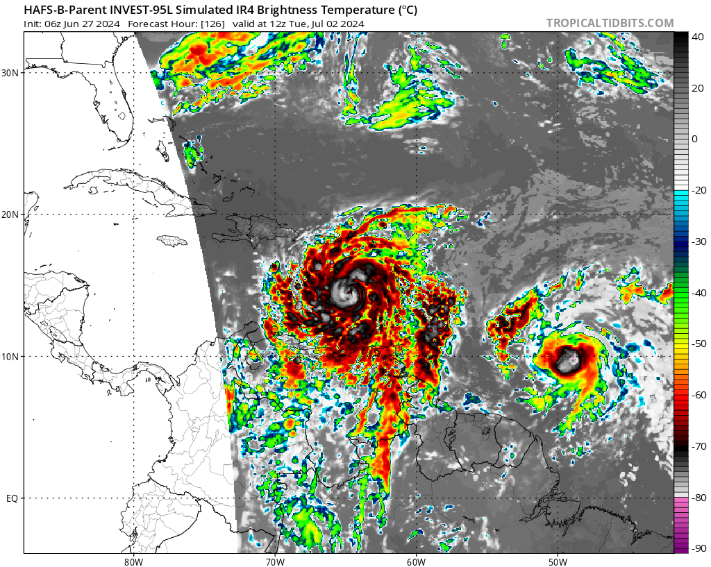
As a result, the environment looks good to excellent for development and maybe even quick intensification eventually, but as you can also see from the images above, there are some potential challenges ahead too.
The NHC telegraphing possible hurricane watches soon is a big deal.
It’s so jova if they put up hurricane watches in the first advisory
-
GET READY BHAIS
BERYL IS ABOUT TO MOG
2. Central Tropical Atlantic (AL95):
A low pressure system located about 1400 miles east-southeast of the
Windward Islands is becoming better defined and the associated
showers and thunderstorms are increasing in organization. If these
trends continue, a tropical depression will likely form later today.
This system is expected to move westward at 15 to 20 mph and
approach the Windward Islands by the end of the weekend, and
Hurricane or Tropical Storm Watches could be required for portions
of that region tonight or early Saturday. For more information,
including gale warnings, see High Seas Forecasts issued by the
National Weather Service.
* Formation chance through 48 hours...high...near 100 percent.
* Formation chance through 7 days...high...near 100 percent.
-
19 minutes ago, Retrobuc said:
I read earlier in the week about a large saharan dust layer, which usually makes development difficult. Why is that not the case here?
Conditions are just mogger for june
-
21 minutes ago, WxWatcher007 said:
Mogged by tutt
over for 95l if this verifies
-
7 hours ago, WxWatcher007 said:
Not directed at anyone—say this every year but this is the annual reminder to be cautious when looking at any of the spaghetti/hurricane models before there’s a true well-defined LLC. Errors can be particularly high and just propagate through a model forecast. Ensembles are the way to go for now.
No problem!
-
8 hours ago, Jebman said:
Wow is that REALLY a second storm behind the first?
Looks like it ngl
-
8 hours ago, Jebman said:
Yeah that would be very CEL for Barbados, if that storm gets to be like Jova.
*it would be very brutal for barbadoscels if that storm gets to be like Jova (cel is a suffix)
Jova is also alternate lingo for “over”
I hope 95L doesn’t become like Jova though
-
I asked AI to predict the peak intensity for 95L and it's not looking good, but I am too high inhib to post the full response here that states the peak intensity (they explicitly gave it). However, I can say this:
Key Factors Influencing Intensity
-
850 mb Zonal Wind Anomaly: Indicates low-level shear due to anomalously westerly winds. This could initially challenge development but is less impactful for a well-developed system like 95L/Beryl.
-
200 mb Zonal Wind Anomaly: Shows anomalously easterly winds aloft, which favor lower shear and promote anticyclonic flow, aiding in outflow and reducing upper-level shear.
-
Deep Layer Wind Shear: Predicted to be low along Beryl's path, which is conducive for strengthening, especially with the unusually warm sea surface temperatures (SSTs).
-
Sea Surface Temperatures (SSTs): Warm SSTs provide ample energy for intensification. Given the temperatures are above average, this will support Beryl’s strengthening.
-
200 mb Wind Speed and Streamlines: Presence of an upper-level anticyclone (ULAC) providing favorable conditions for development.
-
Model Guidance and Intensity Projections:
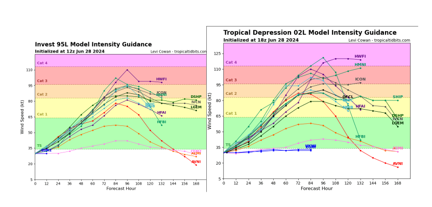
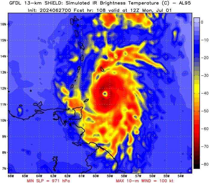
- GFDL SHiELD: Predicts significant strengthening with well-defined characteristics.
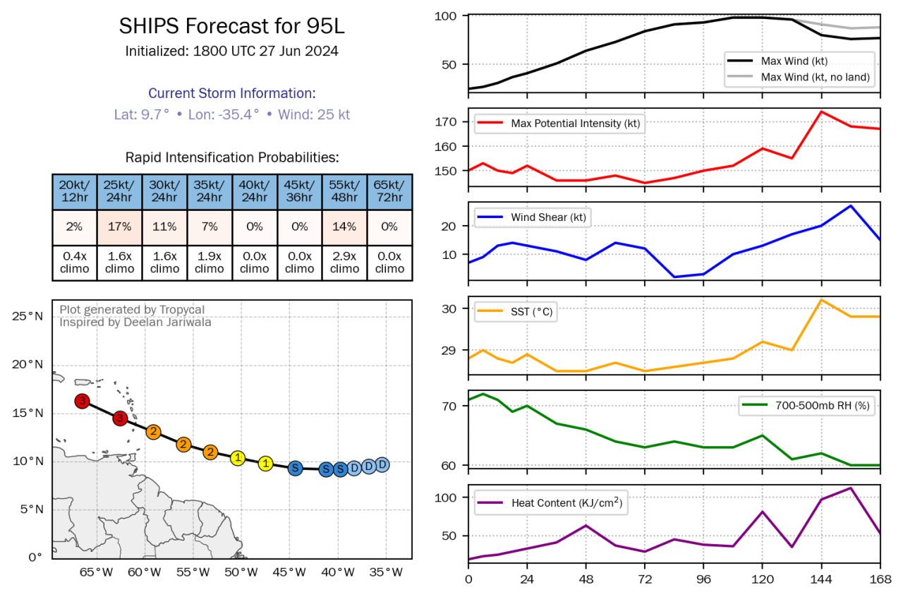
- SHIPS Forecast: Indicates rapid intensification potential with increasing maximum wind speed.
-
-
-
it's so jova for those in the path if this moggercane verifies. Hopefully the TUTT/trades/shear can mog 95L

-
Jova for barbadoscels

-
56 minutes ago, GaWx said:
Some of my relatives have a long ago planned cruise that starts over weekend from FL and goes to Yucatan/Caymans through 7/2. But then goes to Jamaica on 7/3, Bahamas 7/5, and then back to FL. I said all good thru 7/2 but Jamaica on 7/3 COULD get tricky and smaller chance of an issue in Bahamas+.
Any other opinions would be appreciated. Does that sound about right? TIA
Implications for the Cruise:
- Until July 2: The cruise through the Yucatan and Cayman Islands should generally be safe, with the storm expected to remain to the south.
- July 3 (Jamaica): There is a significant possibility of the storm impacting Jamaica around this date. The models show a potential for the system to be at hurricane strength, which could bring strong winds and heavy rain.
- July 5 (Bahamas): The Bahamas could experience effects from the storm depending on its path and intensity. If the storm continues its projected track, it may affect this area, but there is more uncertainty compared to the Jamaica forecast.
-
1
-
Eastern Tropical Atlantic (AL95):
A tropical wave located several hundred miles west-southwest of the
Cabo Verde Islands continues to produce showers and thunderstorms.
This activity is beginning to show signs of organization, and
environmental conditions are forecast to remain conducive. Thus,
further development of this system is anticipated, and a tropical
depression or tropical storm is likely to form over the next couple
of days while the system moves westward at 15 to 20 mph towards the
Windward Islands. Interests in the Lesser Antilles should monitor
the progress of this system.
* Formation chance through 48 hours...high...70 percent.
* Formation chance through 7 days...high...90 percent.-
1
-
-
12 minutes ago, Jebman said:
Better start hoisting Tropical Watches up all across the Caribbean Islands.
If I was down there, I'd get on a plane to northern Alberta, just to be safe.
I don't know why they're only doing upgrades for the CONUS


Hurricane Beryl - Hurricane Warning - Baffin Bay to San Luis Pass Texas
in Tropical Headquarters
Posted
JFL AT BERYL WHAT THE HELL IS THIS ALREADY
Location: 9.8°N 46.8°W
Moving: W at 21 mph
Min pressure: 999 mb
Max sustained: 60 mph