.webp.70c18861c39c8ef8c4811e598978da45.webp)

CurlyHeadBarrett
-
Posts
827 -
Joined
-
Last visited
Content Type
Profiles
Blogs
Forums
American Weather
Media Demo
Store
Gallery
Posts posted by CurlyHeadBarrett
-
-
46 minutes ago, Roger Smith said:
Okay noted in table.
Thanks!
-
On 6/17/2024 at 1:02 AM, CurlyHeadBarrett said:
33/15/8
srs
BTW I changed my username to CurlyHeadBarrett if you don't mind? Thanks in advance @roger smith
-
5 minutes ago, Jebman said:
We are setting more brand new historical markers.
all thanks to global warming.
Seasons like 2014/2013/2006 will be a thing of the past
-
7 minutes ago, Jebman said:
Fixed.
4 minutes ago, Jebman said:We are setting more brand new historical markers.
it's so jova for gomcels if this verifies
also not a single molecule:
-
 1
1
-
-
Just now, Ed, snow and hurricane fan said:
Toss up. 94L looks better on satellite than it ever has.
You never know 94L might be Chris and future 96L might be Debby
-
1
-
-
4 minutes ago, cardinalland said:
Seeing likely 2-3 storms in one week in the Atlantic in June is impressive. I imagine we'll see a lull after as the current kelvin wave is leaving the area, and once the next kelvin wave comes around it's off to the races...
Which storm names do you think we're gonna see?
-
11 minutes ago, Ed, snow and hurricane fan said:
94L to 50% and area E of Beryl now a 7 day cherry.
2. Eastern Tropical Atlantic:
An area of low pressure located several hundred miles southwest of
the Cabo Verde Islands is producing an area of disorganized showers
and thunderstorms.  Environmental conditions appear conducive for
additional development of this system, and a tropical depression
could form by the middle of next week while it moves generally
westward at 15 to 20 mph across the eastern and central tropical
Atlantic.
* Formation chance through 48 hours...low...30 percent.
* Formation chance through 7 days...high...70 percent.
Do you think this or 94L would snag Chris?
-
13 minutes ago, cardinalland said:
It's an interesting case study in the effectiveness of AI right now!
Yeah, only 4 in the US since 1950! But I would imagine there's a few more which made landfall as C3+ in other regions.
have you tried other LLMs? I heard claude mogs
-
1 minute ago, Windspeed said:
-
934mb/140 kt Cat 5 south of Haiti on the 12z HWRF jfl if this verifies I will turn into Hexum
-
1 hour ago, cptcatz said:
If it hits the islands as a major there's a good chance it will be retired. Here's a question for the history buffs: how many major hurricanes have made landfall and not retired? Idalia from last year fits that bill. Any others?
emily
-
Just now, Windspeed said:
24 hours from classification to hurricane aint too shabby...
Not at all
Beryl is on the hurricane version of dbol and hgh
-
20 minutes ago, cardinalland said:
I don't know of a database of all Atlantic major hurricane landfalls, but it's an interesting question for sure.
As for the Lesser Antilles, I used https://coast.noaa.gov/hurricanes/ to map all major hurricanes which tracked through the Lesser Antilles. Every single storm to pass through the Lesser Antilles as a major hurricane since 1954 has been retired *EDIT: except for Hurricane Omar of 2008.
Let's find a hurricane you're interested in.
Why does this phrase make me cage so hard IRL?
-
31 minutes ago, Jebman said:
If that obtains, we better start evaccing the entire Gulf Coast and all of the Florida Coast.
Because if Beryl does not get weakened, and it gets into that GoMex with all that warm shallow water, all of us in the South are pretty much fooked. Especially if Beryl turns out to go full on MOG on us.
Beryl is now a hurricane according to the NHC
Who put dianabol and HGH in the Atlantic Ocean?
-
3 minutes ago, cardinalland said:
Haha it's still wrong! Eloise was retired and Kate made landfall as a Category 2. These AIs really aren't all they're cracked up to be
6 minutes ago, CHSVol said:I asked it to reevaluate:
To accurately address your query, let's verify each hurricane:
1. **Hurricane Eloise (1975)**
2. **Hurricane Bret (1999)**
3. **Hurricane Kate (1985)**27 minutes ago, Jebman said:If that obtains, we better start evaccing the entire Gulf Coast and all of the Florida Coast.
Because if Beryl does not get weakened, and it gets into that GoMex with all that warm shallow water, all of us in the South are pretty much fooked. Especially if Beryl turns out to go full on MOG on us.
JFL
BERYL IS A HURRICANE NOW
IT'S JOVA FOR CARIBBEANCELS
 Hurricane Beryl
Satellite | Buoys | Grids | Storm Archive ...BERYL IS NOW A HURRICANE AND FORECAST TO INTENSIFY QUICKLY... ...EXPECTED TO BRING LIFE-THREATENING WINDS AND STORM SURGE TO THE WINDWARD ISLANDS AS A MAJOR HURRICANE... -
33 minutes ago, Normandy said:
Beryl will be gone after this year
You positive?
-
1
-
-
All of these are the same system

-
21 minutes ago, chubbs said:
It’s over for Caribbeancels, TUTTcels and SALcels, getting mogged by storms in June
14 minutes ago, Jebman said:Basin is already going full MOG on us.
Basin is set to produce prime moggers ngl.
-
27 minutes ago, WxWatcher007 said:
@CurlyHeadBarrett it’s very impressive to see this level of activity this early in that part of the basin.
Basin thinks it’s August 29
-
1 minute ago, WxWatcher007 said:
Yeah it’s definitely possible
Wow. This is mad ngl
-
6 minutes ago, WxWatcher007 said:
A number of models still try to get 94L to TS status briefly in the next 24-36 hours in the BoC before landfall. The last two invests in this area were close but ran out of time. We’ll see if this one gets there.
Regardless, it has been very active for the Mexico coast so far this season…
So debby and Chris might come?
-
4 minutes ago, WxWatcher007 said:
Forecast is now for a major hurricane.
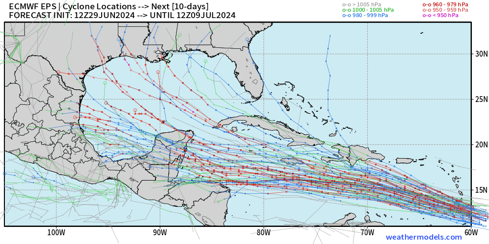
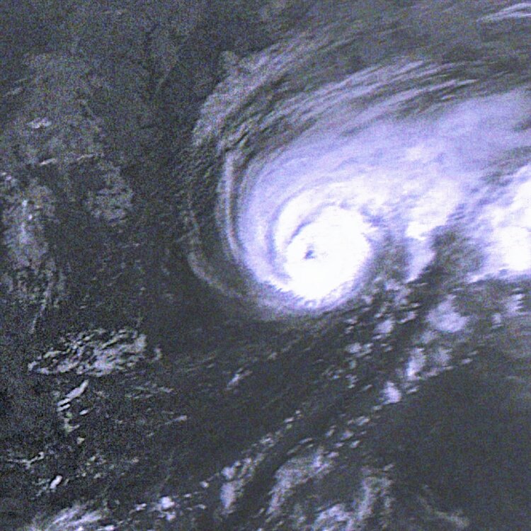
Tropical Storm Beryl Discussion Number   4
NWS National Hurricane Center Miami FL       AL022024
1100 AM AST Sat Jun 29 2024

Satellite images indicate that Beryl has been strengthening at a
quick pace.  The storm is now more symmetric with the low-level
center located beneath an expanding central dense overcast feature.
Showers and thunderstorms are also organized in curved bands on the
west side of the circulation.  The initial intensity is increased to
55 kt, in agreement with the Dvorak estimate from TAFB, and Beryl is
nearing hurricane strength.

Beryl has been wobbling around, but the general motion has been
westward at a fast 20 kt.  A strong subtropical ridge should keep
the storm moving generally westward at only a slightly slower
forward speed for the next few days.  This motion should take Beryl
across the Windward Islands late Sunday night and Monday, and then
across the eastern and central Caribbean Sea early next week.  By
the middle of next week, the cyclone might gain a little more
latitude as it feels some influence from a weakness in the ridge,
before another ridge builds to its northwest.  The NHC track
forecast has been nudged southward based on the trends in the latest
model runs.

The storm has been on a steady strengthening trend since it formed
yesterday, and now that its structure is more symmetric and compact,
it likely will have an opportunity to rapidly intensify given the
low wind shear conditions.  The new NHC intensity forecast
explicitly calls for rapid strengthening and shows Beryl becoming a
major hurricane before moving across the Windward Islands.  The
environment becomes a little less conducive after Beryl moves into
the Caribbean Sea, and some increase in shear will likely end its
strengthening phase and cause slow weakening toward the end of the
period.  This forecast shows more aggressive strengthening in the
short term and a slightly higher peak intensity than the previous
one, and is near the middle of the guidance envelope.


Key Messages:

1. Beryl is expected to rapidly strengthen and be a major hurricane
when it reaches the Windward Islands late Sunday night or Monday,
bringing destructive hurricane-force winds and life-threatening
storm surge.  A Hurricane Watch is in effect for much of the
Windward Islands.

2. Heavy rainfall and localized flooding is expected across the
Windward Islands Sunday night and Monday.

3. Interests in the central and western Caribbean should monitor the
progress of this system.  Users are reminded that there is large
uncertainty at days 4 and 5 and to not focus on the specific
details of the track or intensity forecast.


FORECAST POSITIONS AND MAX WINDS

INIT  29/1500Z 10.0N  47.8W   55 KT  65 MPH
 12H  30/0000Z 10.4N  50.5W   70 KT  80 MPH
 24H  30/1200Z 11.1N  53.8W   85 KT 100 MPH
 36H  01/0000Z 11.8N  57.3W   95 KT 110 MPH
 48H  01/1200Z 12.6N  60.8W  100 KT 115 MPH
 60H  02/0000Z 13.7N  64.3W  100 KT 115 MPH
 72H  02/1200Z 14.9N  68.3W  100 KT 115 MPH
 96H  03/1200Z 17.0N  75.5W   90 KT 105 MPH
120H  04/1200Z 18.7N  81.4W   80 KT  90 MPH

$$
Forecaster Cangialosi
Jfl at the major peak. It’s over
-
5 hours ago, tiger_deF said:
Beryl is looking fierce right now. I’d say a 45-50 mph tropical storm still intensifying at a fast clip.
What’s most intimidating is the total lack of other clouds around the system. Once the system fully stacks we are going to see some beautiful outflow.
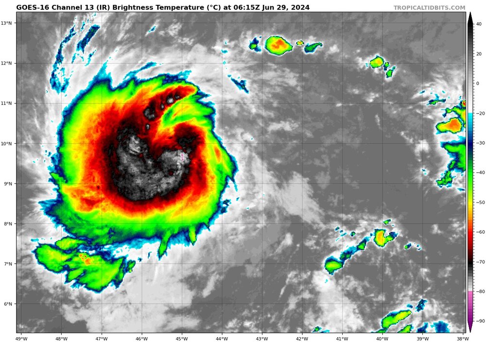
Jfl beryl is at a conservative (NHC own words) 60mph rn
-
Based on the various subjective and objective satellite
intensity estimates, the initial intensity is increased to a
possibly conservative 45 kt.
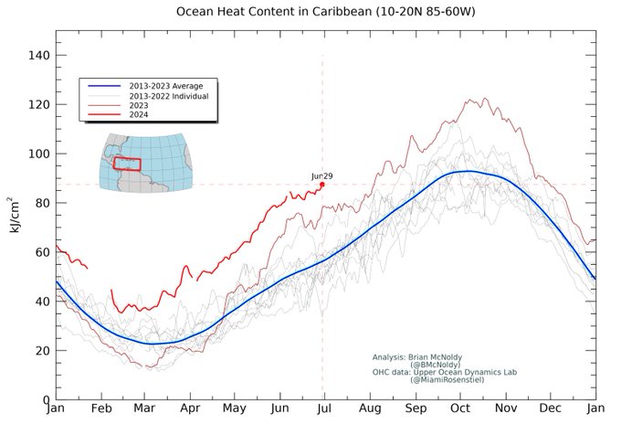
Atmospheric and oceanic conditions over the western tropical
Atlantic and the eastern Caribbean Sea are abnormally favorable for
strengthening, and the rapid intensification indices in the SHIPS
model are showing a significant chance of rapid intensification. The
new intensity forecast continues to call for bERyl to become a
hurricane before reaching the Windward Islands, and it now calls for
a peak intensity of 95 kt in 60-72 h.  This peak could be
conservative, as several of the intensity guidance models forecast
Beryl to become a major hurricane.


Hurricane Beryl - Hurricane Warning - Baffin Bay to San Luis Pass Texas
in Tropical Headquarters
Posted
I'm a millennial (28 pushing 29)