

jlewis1111
-
Posts
611 -
Joined
-
Last visited
Content Type
Profiles
Blogs
Forums
American Weather
Media Demo
Store
Gallery
Everything posted by jlewis1111
-
Richmond Metro/Hampton Roads Area Discussion
jlewis1111 replied to RIC Airport's topic in Mid Atlantic
Hopefully tonight and tomorrow's storm is just the appetizer for next weekend and we get our dessert -
Richmond Metro/Hampton Roads Area Discussion
jlewis1111 replied to RIC Airport's topic in Mid Atlantic
12z gfs Il take it -
Richmond Metro/Hampton Roads Area Discussion
jlewis1111 replied to RIC Airport's topic in Mid Atlantic
@stormtrackerAny possible way you can remove my daily post limitation please. Been here since 2010. Thank you. I would have messaged you but its turned off. Sorry to clutter this thread -
Richmond Metro/Hampton Roads Area Discussion
jlewis1111 replied to RIC Airport's topic in Mid Atlantic
maybe a tick south however we lost some snow accumulation on this run. If you compare 0z last night vs 12z today. I really dont pay attention to the 6z and 18z suites as they dont use fresh data -
Richmond Metro/Hampton Roads Area Discussion
jlewis1111 replied to RIC Airport's topic in Mid Atlantic
Because they use the nam and gfs for the forecast -
Richmond Metro/Hampton Roads Area Discussion
jlewis1111 replied to RIC Airport's topic in Mid Atlantic
Every model this am has the snow trending more south. Not sure what you guys are looking at. Compare the 12z gfs yday to todays 12z gfs and you will see what Im talking about. Euro is still south Icon south other models going toward the euro. -
Best post so far this morning. Tired of seeing people backyard posts about each model. Time for storm mode imo
-
Richmond Metro/Hampton Roads Area Discussion
jlewis1111 replied to RIC Airport's topic in Mid Atlantic
bro not for next weekend lol -
Richmond Metro/Hampton Roads Area Discussion
jlewis1111 replied to RIC Airport's topic in Mid Atlantic
Bro really? Dont be a weenie... Have you seen next weekend's storm? Stop -
Richmond Metro/Hampton Roads Area Discussion
jlewis1111 replied to RIC Airport's topic in Mid Atlantic
Why is the dc forum tripping over the NAM? We arent even in the Nam zone yet. -
January: Medium/ Long Range: May the Force be with Us....
jlewis1111 replied to Weather Will's topic in Mid Atlantic
Euro is most important today as other models have been trending towards it. Important to see if it holds serve or starts trending a dif direction. Last night you guys were hugging the gfs at midnight now you could careless cause its not good for your backyards. You guys are funny when it comes to snow. -
January: Medium/ Long Range: May the Force be with Us....
jlewis1111 replied to Weather Will's topic in Mid Atlantic
A Lot of weenies in here today. Grasping at whatever model is good for the backyard lol -
How high did it get with Helene?
-
That was before the storm made landfall Im sure it was much higher then that for a final Height
-
Once again the gfs looks like it will nail another storm with strength and direction. Not sure why you guys are even looking at the euro. It did crap with Helene. GFS is king til it isnt. Also with Helene GFS wasnt showing the sheer and weaking like other models were kinda the same story with this storm.
-
Like I said yday gfs is locked in and like others once again was showing wind sheer now that is dissapating near land like it did with Helene. Gfs has been a beast lately.
-
The GFS nailed down Helene a week out with a pressure of 938 and hitting a few miles west of where it actually hit. Not bad a week out. Euro had barely anything. Other models were showing wind sheer and ripping it apart before landfall. Lets see if the GFS scores again as once again It sniffed Milton out first too and has been zero in on Tampa area unfortunately.
-
I dont post much but will say this. GFS nailed Helene with size and location many days out. Also many models showed in the 3-4 day range out wind sheer and Helene weakening upon arrival at the coast. Did that happen? Nope.. Im all in on the GFS until it proves me wrong. Its been dead on lately Also the euro sucked with Helene.
-
Richmond Metro/Hampton Roads Area Discussion
jlewis1111 replied to RIC Airport's topic in Mid Atlantic
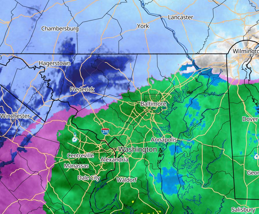
yup will be lucky if we get a inch. Even dc looks not so great. Radar looks like poop... Dry air winning? -
Jan 15-16 Storm Threat Thread: The Return of Hope??
jlewis1111 replied to stormtracker's topic in Mid Atlantic
You guys really have lost your minds. Putting up a storm thread for maybe a inch best. LOL wow what has this forum gone too -
Looks like the euro was the best model with what is actually happening today imo From this past week
-
-
DC the new Atlanta... Just how it is. Been watching this forum all week. So much hype for what nothing today. Maybe end of month will see however winters just suck now
-
Just like with Jim Cramer with stocks go with the opposite and do the same with winter forecasts. They are all usually end up wrong. Go with the opposite
-
Food for thought there has only been 5 August's with not tropical cyclones in the atlantic. They were all followed by el nino or neutral winters. None were La nina. Will see This past August now makes 6


