NoCORH4L
-
Posts
627 -
Joined
-
Last visited
Content Type
Profiles
Blogs
Forums
American Weather
Media Demo
Store
Gallery
Posts posted by NoCORH4L
-
-
18 minutes ago, etudiant said:
Exactly!
People know this and consequently prefer to risk their lives by riding out the storm, just to avoid losing all their possessions to criminals and vandals.
This is why I have minimal things of value lol.
If I was anywhere near the ocean.....PTFO.
-
 1
1
-
-
2 hours ago, understudyhero said:
I just checked out St. Armand’s Circle - all the first floor stuff got three feet of waves last hurricane.
These are places I have been going to for two decades and I doubt they open again after this storm
Probably for the better. Probably shouldn't be there to begin with, as terrible as that sounds.
-
HAFS-B: tons of weakening near landfall. Maybe cat 2 possible?
-
 1
1
-
-
1 hour ago, Pityflakes said:
Obviously too early but I'd be breathing a sign of relief in Tampa this am based on weakening and track trends. Even if they catch the eye wall, a broad eye of a Cat 2/3 struggling w/ dry air/structure isn't going to produce a devastating surge w/ a mostly offshore flow. Surge will be more wind than pressure driven; could see Siesta Key and areas south hitting the max potential though of 10-15 feet.
44 minutes ago, jm1220 said:I see posts mentioning the presentation is getting better again and it’s borderline Cat 5.
See above
-
 1
1
-
-
27 minutes ago, lilj4425 said:
I guess the government cancelled this one.
Lol nah I'm not like that. I'm just commenting on the general theme in the main thread. But ya now we're back to big time.
-
5 minutes ago, jm1220 said:
Who’s “everyone” saying “weakening badly” and who’s definitely saying it makes landfall S of Tampa, an area still populated with hundreds of thousands of people?
Everyone posting in the main thread. Yeah I mean it'll still be bad, but that's like saying a 3' snow storm is as bad for Albany as it is for NYC.
-
3 minutes ago, LongBeachSurfFreak said:
Before I go full on sarcasm, care to explain why you feel this way? I’m pretty sure a sting jet with gusts over 100mph well inland is a pretty big deal.
She's hurting, everyone saying weakening badly, and south of TBA. Makes it meh. People already saying CAT1 landfall in main thread.
-
 2
2
-
 2
2
-
 1
1
-
-
Turning into a nothingburger except the barrier islands
-
 1
1
-
 2
2
-
 3
3
-
 6
6
-
-
1 hour ago, LawdogGRNJ said:
Curious, why is the amount of wind shear that Milton has to go through to get to FL not forecast to weaken it dramatically?
Powerful storms create their own environment
-
4 hours ago, Random Chaos said:
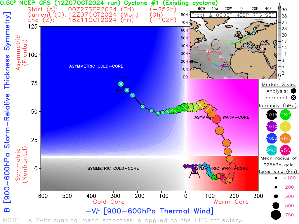
It's gone extratropical with a warm asymetric core. I find it fascinating that Europe is getting this storm. It's a rare season that sees anything hit there.
Here's the cyclone phase from GFS showing the core structure (source: https://moe.met.fsu.edu/cyclonephase/ )
Looks like some decent gusts too
-
I love the damage porn in canes, but at the same time I feel I shouldn't.......
-
Huh....why can't they just enter the eye wall?
-
21 minutes ago, Normandy said:
Milton putting on a clinic right now
Peaking too soon
-
Maybe the ERC happening now will cause it to max out sooner and weaken before LF
-
1 hour ago, jburns said:
It’s Helene. And yes, almost certainly.
Maybe they'll correct it to Helen, since Helene isn't a real name.
-
 5
5
-
 4
4
-
-
2 hours ago, CoastalWx said:
Saturday seems fine. Maybe a shower in nrn ORh county?
Yeah I should have specifically mentioned more for NNE. Not looking so great, clouds and showers from late Fri night to late Saturday afternoon for all the peepers.
-
 1
1
-
-
Will Helen be retired?
-
 2
2
-
-
Weekend, namely Saturday, starting to look like DooDoo
-
 3
3
-
-
People saying it's cutoff, it's not cutoff.....a major interstate is operational out of Ashville
-
 3
3
-
-
8 minutes ago, NorthHillsWx said:
Exceptional, catastrophic, unimaginable flooding ongoing in the western Carolina’s. Unreal
Pics?
-
Way way east
-
Good thing it's just gators and pelicans along the coast
-
 1
1
-
-
Just now, Damage In Tolland said:
Same thing around here. Lots of hideous browns and ugly brown / orange. Another sub par foliage season enroute. Things are way way ahead of schedule
I thought low water concentrates the sugars and enhances the vibrancy?
-
The weekend has really turned to crap north of the border. Showers all day on Saturday, especially in the mountains, and then through Sunday to the evening. Hate to see it.
-
 1
1
-
 1
1
-


Hurricane Milton Banter
in Tropical Headquarters
Posted
What is so valuable in a home you can't leave behind? A TV? An old china set in a hutch from Grandma?
Take the valuable jewelry, photo books, and important docs and leave. Maybe the chain saw and gas cans so you can clear your way back in after.