AstronomyEnjoyer
-
Posts
1,081 -
Joined
-
Last visited
Content Type
Profiles
Blogs
Forums
American Weather
Media Demo
Store
Gallery
Everything posted by AstronomyEnjoyer
-
 Neat! For the uninitiated...
 -
He said you guys in the royal sense, lol, not "royal you". I dunno, I understood his intent immediately.
-
Ha, I saw that. Originating in Lake Huron, jetting across that part of Ontario where they've drawn up the road grid all wonky, getting a boost over Lake Ontario, then exiting at the southern tip of Rhode Island. Behold, the power streamer!
-
Haha, some of you guys need to read more or something. Tip's style of writing is completely different from Weatherwiz's style. To give my favorite non-explanation - you can tell because of the way it is.
-
It was a Flop... February 2024 Disco. Thread
AstronomyEnjoyer replied to Prismshine Productions's topic in New England
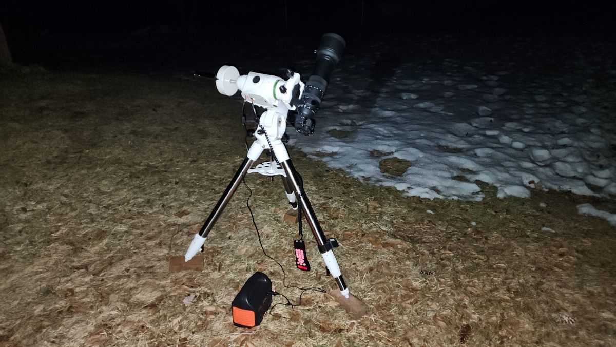
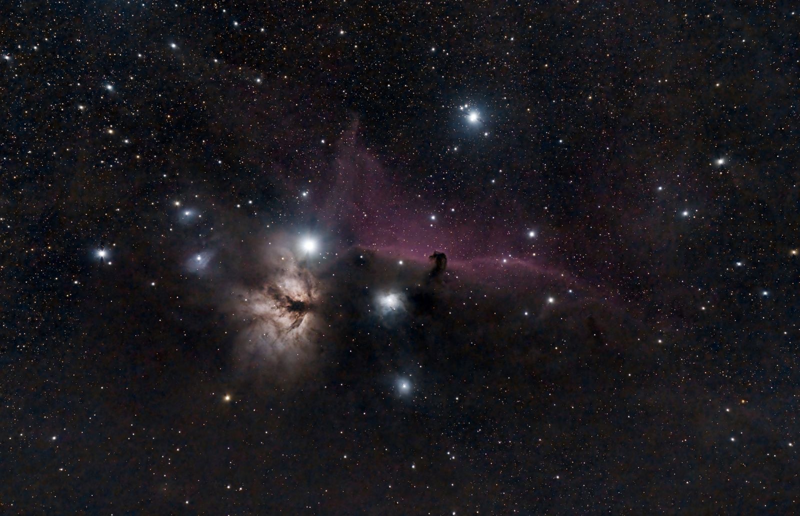
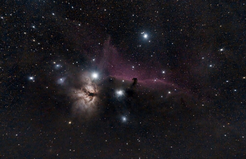
Clear weather tonight and I was able to set out some heavier equipment in the yard now that I've got a grass patch opening up. The setup and the shot.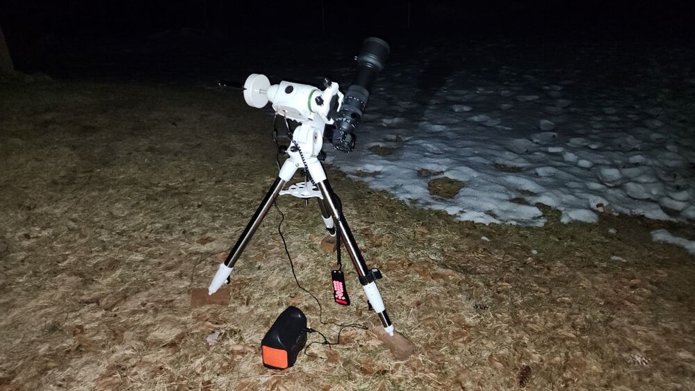
-
NWS is calling for 50 mph gusts here Wednesday night. More pinecones shall be flung all over the yard at a minimum I suppose. There's hundreds - if not thousands - to be picked up and/or mowed over already.
-
It was a Flop... February 2024 Disco. Thread
AstronomyEnjoyer replied to Prismshine Productions's topic in New England
Don't apologize! Your wife's health is infinitely more important than this forum. I hope everything works out well! -
It was a Flop... February 2024 Disco. Thread
AstronomyEnjoyer replied to Prismshine Productions's topic in New England
The GFS fantasy system is still there. As was discussed, it's the result of erroneous clown map generation which, for whatever reason, seems to plague vendor interpretations most frequently with the GFS (so yes, it ain't going to snow nearly as much as it is saying and never was, but it's still modeled as it was before for the most part). Here, I made a tool in Excel last night that allows you to input a few characteristics of a very simplified weather system in order to generate a QPF "map" along a geographic line. In this case, we put (in the yellow) a front moving at 50 kph with a width of 250km. The rate of precip. under the front is 0.05 in/hr. We then sample at the rate of one frame every 6 hours. As you can see from the total QPF output graph, there are regions along our line where the sampled total QPF drops to zero. A tiger stripe (or anti-stripe) is forming every 300km (or every 6 hours) as a result. This is happening because we are under-sampling. For total QPF, the vendor products usually manage to not do this, but because there is such a large error in assigning precip type to QPF, the tiger striping artifact is showing up for reasons very similar to my model's. I am going to add temperature to my model in order to more accurately produce the tiger stripe gradient artifact, but am too lazy right now. -
It was a Flop... February 2024 Disco. Thread
AstronomyEnjoyer replied to Prismshine Productions's topic in New England
The trigger shall be pulled on central AC at some point, but for now, I'll probably just suck up the few uncomfortable days. The house is fairly well shaded by trees in the afternoon during summer and triple pane windows help with insulation. If I end up with some type of window or floor unit it will be to help keep the humidity levels of the piano in check rather than for my own comfort, haha. I care more about it than me! -
It was a Flop... February 2024 Disco. Thread
AstronomyEnjoyer replied to Prismshine Productions's topic in New England
890 ft. Not usually too bad in all honesty. -
It was a Flop... February 2024 Disco. Thread
AstronomyEnjoyer replied to Prismshine Productions's topic in New England
No central AC, no window units here. Swamp-ass is coming for me. -
It was a Flop... February 2024 Disco. Thread
AstronomyEnjoyer replied to Prismshine Productions's topic in New England
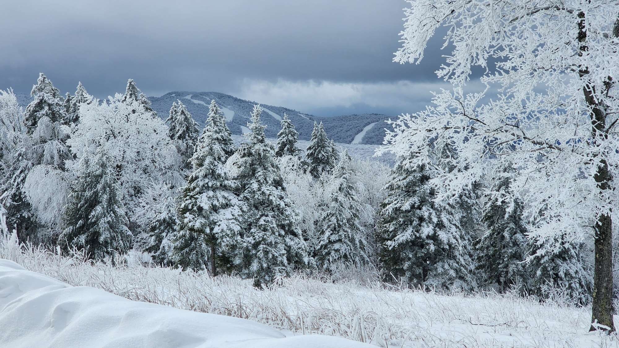
East slope of Sunapee from yesterday's walk. That field will be snow free by Thursday is my guess. -
It was a Flop... February 2024 Disco. Thread
AstronomyEnjoyer replied to Prismshine Productions's topic in New England
Yeah I know, haha. It always bothered me in the movie when Morgan Freeman's character calls 500 yards just shy of a half mile when it really is only 60 yards longer than a quarter mile. -
It was a Flop... February 2024 Disco. Thread
AstronomyEnjoyer replied to Prismshine Productions's topic in New England
Hey now, Andy Dufresne's shit pipe was 500 yards in the movie I'm pretty sure. -
It was a Flop... February 2024 Disco. Thread
AstronomyEnjoyer replied to Prismshine Productions's topic in New England
Hit a low of 7.6°. Pointless cold, go away. -
It was a Flop... February 2024 Disco. Thread
AstronomyEnjoyer replied to Prismshine Productions's topic in New England
Now that you've given me a handle on what the error is, I've been sitting here for the past half hour drawing spatial and time domain graphs trying to conceptualize precisely how the error is occurring, haha. I've even drawn up a little meteorological grid model to try to visualize what would happen to each forecast point as a front washes over. Bottom line is - that artifact drives me nuts. It's egregious as hell, and it seems like there should be a relatively easy way to ensure there is better handling on the assigning of precipitation type to QPF. However, I'm not so dumb that I don't realize that if it were really so easy to fix, folks much smarter than me would have already fixed it. Thanks for helping explain it though! -
It was a Flop... February 2024 Disco. Thread
AstronomyEnjoyer replied to Prismshine Productions's topic in New England
Wow, do these maps really take all QPF from prior frame to current frame and assume that it's all at current frame temp profiles?. I assumed they used some variety of interpolation between frames to try to get a crude approximation of what was what. That could still explain tiger striping artifacts in quick hitting storms with wild temp swings. -
It was a Flop... February 2024 Disco. Thread
AstronomyEnjoyer replied to Prismshine Productions's topic in New England
Mosquitos weren't bad at all last summer here. I traipsed around the woods often as well, and ended up never finding a tick on me (for what it's worth). The bugs that were popping up with above average frequency (and I still find them in the house on occasion) were Western Conifer Seed Bugs. They seem(ed) to be everywhere. -
It was a Flop... February 2024 Disco. Thread
AstronomyEnjoyer replied to Prismshine Productions's topic in New England
Planter boxes are freeing up! They will certainly be snow free at some point this coming week. But then I'll need to clean up the mess underneath the collapsed portable garage. Which I'm not looking foward to. At all. Maybe I can use the loader to pile the rest of the yard's snow on top of it so I don't have to think about it until June... -
It was a Flop... February 2024 Disco. Thread
AstronomyEnjoyer replied to Prismshine Productions's topic in New England
06z 3km NAM tries to give a bit of a coating to many Monday morning. Out there in range for the NAM though. -
It was a Flop... February 2024 Disco. Thread
AstronomyEnjoyer replied to Prismshine Productions's topic in New England
Moon and some brighter stars were shining through diffuse clouds last night. Clear tonight, but might actually go below my 2023/2024 winter low of 3.4°. -
It was a Flop... February 2024 Disco. Thread
AstronomyEnjoyer replied to Prismshine Productions's topic in New England
I remember leaving UML as the spring semester ended, and there was still a huge pile on the north side of the north parking garage were they had been pushing it off the structure. Always wondered how long that pile held out. -
1.9" new for a total of 4.8" in Feb. and 46.3" for the season. Unless this longshot anafront thing that keeps popping up on models happens (to some snowy extent) late next week, I'd say that's going to do it for February.
-
Someone has to mention Feb 23 obs
AstronomyEnjoyer replied to 40/70 Benchmark's topic in New England
Town came by at about 1:30pm to plow the half inch of snow that was left at that point. Big difference in how this looked this morning. -
Someone has to mention Feb 23 obs
AstronomyEnjoyer replied to 40/70 Benchmark's topic in New England
1.9" for the total. Couldn't quite make it to 2". It's now melting so fast that water is just about pouring off the roof - just getting absolutely nuked.