AstronomyEnjoyer
-
Posts
1,081 -
Joined
-
Last visited
Content Type
Profiles
Blogs
Forums
American Weather
Media Demo
Store
Gallery
Everything posted by AstronomyEnjoyer
-

Someone has to mention Feb 23 obs
AstronomyEnjoyer replied to 40/70 Benchmark's topic in New England
1.8" at last measurement. Starting to wind down here. My town seems to have had the good sense not to try and plow the dirt road I live on. I'm sure I've jinxed that now... -
Someone has to mention Feb 23 obs
AstronomyEnjoyer replied to 40/70 Benchmark's topic in New England
Is that a structural stone building I spy? Very cool. (Even if not, it's still very cool) -
Someone has to mention Feb 23 obs
AstronomyEnjoyer replied to 40/70 Benchmark's topic in New England
Heavy in this band pushing through. Great snow growth - this is fairly high ratio stuff all things considered. -
It was a Flop... February 2024 Disco. Thread
AstronomyEnjoyer replied to Prismshine Productions's topic in New England
Oh wow, you might make a run at 3". I'm only at 1.2" here. Figures that this would be a storm we bust "positive" on. -
Someone has to mention Feb 23 obs
AstronomyEnjoyer replied to 40/70 Benchmark's topic in New England
31.9° and 0.8" new. Looks like I'll be able to pass 1". Surprisingly passable snow too - decent growth and not terribly wet. Makes for a pretty morning. -
It was a Flop... February 2024 Disco. Thread
AstronomyEnjoyer replied to Prismshine Productions's topic in New England
Oh come on, you can do better than that! Don't waste your posts repeating what someone just said. *Edit* What I mean to say is, use those posts wisely. You get how many per day? (This is a trap, don't answer!) *Edit #2* Sorry man, just giving you a hard time. -
It was a Flop... February 2024 Disco. Thread
AstronomyEnjoyer replied to Prismshine Productions's topic in New England
00z GFS bringing some anafront fun at like 150 hours. It really puts the "clown" in clown map. Very real solution, GFS/Pivotal. -
It was a Flop... February 2024 Disco. Thread
AstronomyEnjoyer replied to Prismshine Productions's topic in New England
Latest HRRR (and a few others) tries to get that precipitation over Pennsylvania to us as the main event at around 5am... I'm using the term "main event" really loosely here. But yeah, the radar right now, sheesh. -
It was a Flop... February 2024 Disco. Thread
AstronomyEnjoyer replied to Prismshine Productions's topic in New England
Light snow has commenced up here. Bad kind of storm to be on the east slope really, but it's a bad storm in general. -
It was a Flop... February 2024 Disco. Thread
AstronomyEnjoyer replied to Prismshine Productions's topic in New England
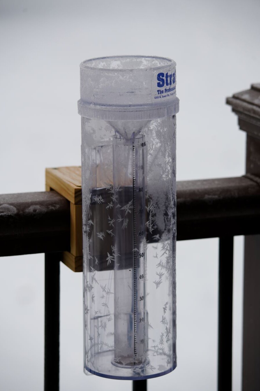
13.3° for the low this morning - Stratus is all frosted up. I don't know, I've got to be one of the biggest weenies around, but this cold weather sucks if it ain't gonna snow. I think maybe I'm starting to see the light. Bring on the warmth?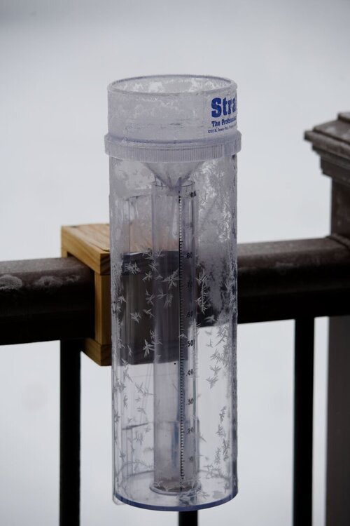
-
Someone has to mention Feb 23 obs
AstronomyEnjoyer replied to 40/70 Benchmark's topic in New England
17.6° with diffuse cloud cover here right now, has the feel of a good winter storm approaching... instead, slop is on the menu. Hoping we get enough to cover the ugly on existing snow piles but not enough that it's really ever able to accumulate on roads. That'd be a "win" in my book. -
It was a Flop... February 2024 Disco. Thread
AstronomyEnjoyer replied to Prismshine Productions's topic in New England
Snowpack is starting to get very disparate. 9 to 12 inches still in the flat part of the yard, but none on some of the south facing slopes. Gorgeous day though. -
Someone has to mention Feb 23 obs
AstronomyEnjoyer replied to 40/70 Benchmark's topic in New England
GYX snowfall map as of 30 mins of posting just in case anyone is browsing/lurking and didn't get the memo (we ain't got much of a storm comin'). -
It was a Flop... February 2024 Disco. Thread
AstronomyEnjoyer replied to Prismshine Productions's topic in New England
Low of 7.7° this morning. Will be interesting to see if Saturday night/Sunday morning beats that. Guess I need to take up ice fishing or something. -
It was a Flop... February 2024 Disco. Thread
AstronomyEnjoyer replied to Prismshine Productions's topic in New England
This smells like bait. -
This wasn't on my radar, so thanks for the heads up! Comets offer a unique challenge in astrophotography in that their apparent motion with respect to the field of background stars is rather rapid. This makes it difficult to integrate imaging data that was taken over several minutes or even hours as the comet will have visibly "moved" in that time. Hard to stack images on top of one another when they are literally impossible to align!
-
Someone has to mention Feb 23 obs
AstronomyEnjoyer replied to 40/70 Benchmark's topic in New England
Yeah, looks that way. We're down to hoping for a miracle at this point. -
Someone has to mention Feb 23 obs
AstronomyEnjoyer replied to 40/70 Benchmark's topic in New England
18z Euro Clown for the curious. Nice to see a coherent swath at least. -
Someone has to mention Feb 23 obs
AstronomyEnjoyer replied to 40/70 Benchmark's topic in New England
18z GFS. Decent front end thump (comparatively), but doesn't really get the coastal going until wide right. -
Someone has to mention Feb 23 obs
AstronomyEnjoyer replied to 40/70 Benchmark's topic in New England
Ah-ha! That's more like it ICON - give me a local jackpot (kinda) like you always do. -
It is indeed!
-
Lake Sunapee in the foreground and Killington 44.3 miles distant. Was hoping for better clarity today although it wasn't bad by any means. Did notice clouds off to the north. I suspected you guys up there were busy getting fake snow again. I waltz in here and my suspicions are confirmed.
-
Someone has to mention Feb 23 obs
AstronomyEnjoyer replied to 40/70 Benchmark's topic in New England
I took a photo of Okemo across the Connecticut River valley from a hill on Lake Sunapee today and you can actually see the lack of snow coverage down in the valley. The most obvious bare spot in this photo is right outside the Claremont "downtown" area. -
It was a Flop... February 2024 Disco. Thread
AstronomyEnjoyer replied to Prismshine Productions's topic in New England
Bottomed out at 3.4° this morning. Coldest it's been here this winter. -
Someone has to mention Feb 23 obs
AstronomyEnjoyer replied to 40/70 Benchmark's topic in New England
06z Euro at 90 hours has a better defined coastal low as well.