
Bob Chill
-
Posts
35,665 -
Joined
Content Type
Profiles
Blogs
Forums
American Weather
Media Demo
Store
Gallery
Posts posted by Bob Chill
-
-
4 minutes ago, WinterWxLuvr said:
Just at a glance but looks like the gfs, icon, and euro all just made big moves with this. Not saying huge but Def looks more significant
We are a really streaky area for whatever reason. Long droughts followed by multiple condensed events is far more common than smooth evenly spaced winters. Prob magical thinking but imho, getting a nice event last night is a sign that Fri will work out "ok". My expectations are it will never look worse than 1-3 in general leading in and even though boom ingredients are largely absent, maybe it finds a way anyway just cuz.
-
 10
10
-
-
Me thinks it gon b a lottle crunchy tomorrow morning.
-
10
-
-
4 minutes ago, Kmlwx said:
It always makes me feel better when YOU say something like this...but I will never be able to feel locked into snow here this many days out

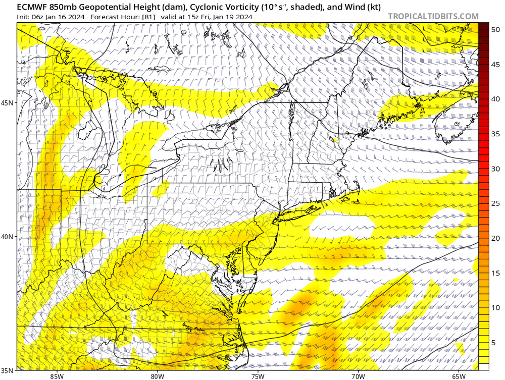
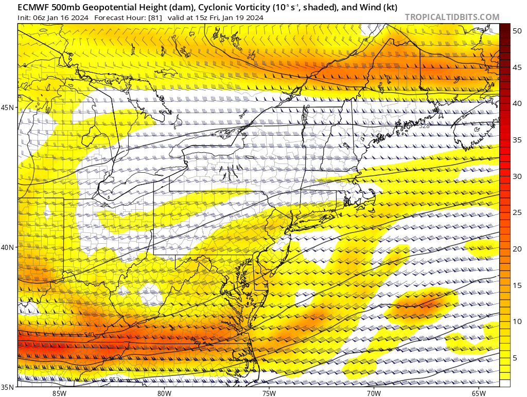
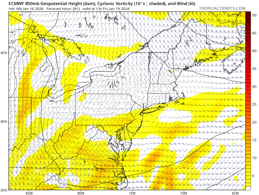
The upper level feature isn't a phantom. It's on all guidance in about the same place. The tricky part from what I see is the 850 low pass. For example, 6z euro has a decent vort pass:

But the 850 low runs overhead. Boom scenario will likely be north of that. But for right now it's an overhead pass so much of our area isn't in the vigorous zone. 850 circ is parked right in the WV panhandle. Run that over EZF and we can get a little more excited. Right now, gun to head, 1-3" with some modest upside.
-
10
-
-
55 minutes ago, WxUSAF said:
Euro and 6z gfs both in the 1-2” range. GGEM more. Maybe we can juice this up a bit as we get toward game time like with this event.
3-4 looks like max boom from what I'm seeing. Not sure there's enuff wiggle room for anything bigger. Good thing about the event is it will be instability driven moreso that lift/upglide. High ratio snow globe potential could bubble up as the upper level stuff moves overhead. If 12z globals all put down an inch or 2 today, we can prob bank on some amount of accum snow
-
15
-
-
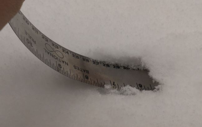
Gonna go with 4.7". This was a pure old school TN valley swiper. These types of storms make up the balance of "good memories" during the 70s and 80s. Cold 2-4/3-5 events were something we could count on a few times in any average or good winter. I hope everyone enjoyed it as much as me. Even though it was a "smallish" event, it was a special one for multiple reasons.
-
31
-
-
1 minute ago, lee59 said:
Just talked to someone in Rockville and they said more like 3 inches.
They didn't take the advanced measurement and stat pad course in college.
-
 9
9
-
-
Serious deathband. Over 6" already
-
3
-
22
-
-
Gettin deathband'd. Leveled up from light snow. 3" by 9pm? Stay tuned!
-
13
-
-
Doin pretty well. 2.2-2.3". Had the dog out in woods for an hour. No flashlight needed. Love that when it snows near cities.
Side roads were terrible. Insurance companies will have busy signals tomorrow lol
-
13
-
2
-
-
1 minute ago, stormtracker said:
PLENTY of options down here. Time for some Gelato Cookies.
It was a tough decision but I went with dosidos #22. May add in some fuel biscuits if things get really dicey
-
4
-
1
-
 1
1
-
-
3 minutes ago, stormtracker said:
Connecticut Ave starting to cave! This is a real storm now.
Cannabis delivery and shelter in place is the only option. Operation Vigilance
-
4
-
4
-
-
Finally over an inch. Feelin optimistic for 4". NW DC could easily get the same imho. This is a good setup with favorable stripe. Rare lol
-
14
-
-
Home from CT. Moco death band setting up early it appears. Getting the hazy look with light snow now. Awesome.
-
16
-
-
25 minutes ago, Scarlet Pimpernel said:
I think all models have been advertising a relax soon after whatever occurs Fri-Sat (i.e., the following week). But I also thought indications were that warmup/relax would be relatively short-lived and we'd be morphing back into a favorable look by the end of the month. I gave a quick glance at the GEFS mean the other day and that seemed to be the case, but I'll let others who have been following that chime in with better detail.
The relax is quite different than a pac jet type of pattern. That's happened so much recently that a "relax" is becoming synonymous with "continental Pac invasion" lol.
When cold retreats next week, flow will be slow and cold will mostly just decay and not be "replaced". What brings cold back on the ens is a very efficient way to go from warm/blah to a single front then cold enuff. Cold continental air from central Canada pushes down into the conus SE over the lakes into the east. Ens guidance unanimously agrees that the Epo and/or pna ridges remain favorable. Potentially for weeks. In this type of setup a -AO regime delivers the goods because of favorable ridge axis offsetting lack of a NAO block when the AO displaces the TPV to hudson bay or south. The look reminds me of Feb/Mar 2003.
Eta: I left out transient 50/50s would be the key piece for a big storm with the advertised look going into early Feb. We'll see about the NAO. So far it doesn't look to reload quickly
-
10
-
 2
2
-
-
3 minutes ago, Ji said:
From 2.8 to 2.83?CWG boom baby!

-
7
-
1
-
-
Clear skies and 23 in CT lol. Heading south in a few. Chasing the jackpot on this one. Gonna roll thru Columbia first and make sure @WxUSAFis jackin' and then drive thru the center of the death band to Rockville.
-
5
-
-
12 minutes ago, Deck Pic said:
If we had a 20-30" winter last year, we'd probably still follow this closely, but without the desperation
These types of events used to be a staple here. 70s-80s had plenty. Looking forward to it. Felt pretty good last week about a couple cold inches. Seems like a lock at this point.
-
14
-
-
14 minutes ago, Terpeast said:
In this case, yes.
Yessir. All storms must be looked at individually. Models have strengths and weaknesses. From what I've seen, no model is good at nailing volatile NS setups beyond 3 days. All the meaninful development happens inside of that range. Getting the lead in right AND all the fancy stuff is a seismic butt ton of math lol.
Climo and odds say a boom scenario is the least likely. Lots of history there. OTOH- we usually get some accum snowfall with setups like this. They aren't remembered because there's usually an underlying disappointment after "the mid range boom runs" lol.
My total wag is most of us are good for a cold couple inches. Exactly how is above my pay grade. Lol
-
6
-
-
8 minutes ago, SnowenOutThere said:
That's sorta surprising, would have expected a consensus to start forming by now instead of them growing more apart.
Problem is storm type. Volatile NS, thin margins, and development at our latitude. Far far different that the recent fail that lifted out of the gulf. If you were around in 2013-15 winters we had a lot of this stuff and it was never resolved until 72 hours at best. Some of the events those winters actually popped up at 72-96hr leads with no previous signal.
The goal posts haven't really changed. Somewhere between a complete whiff and a good storm. Any time you have a setup where models are developing snow basically overhead, don't get married to anything until that development is within 72 hours minimum. These snow events are very complicated from NWP perspective. They have a long history of being phantoms and booms. That said, this setup is our best of the season by far. But it won't be easy on the nerves if you track ops every 6 hours. One of them will almost always look worse or go the wrong way or show the fail option. Full agreement is a short range game
-
12
-
7
-
-
3 minutes ago, SnowenOutThere said:
And remember that the 10:1 ratios shown may be too low for this event too
You're not wrong but until 0:0 is off the table, all other ratios don't excite me too much. What we really need to figure out is how to get the 12:0 ratio then we don't have to care about precip anymore.
-
14
-
7
-
-
17 minutes ago, Maestrobjwa said:
You think it gets less NS dominant as we head get closer to the second half? (Sounds like the tpv getting set up in a less ideal spot was a bit of a chaos/bad luck thing? Lol)
Think of it the other way around. NS dominant pattern (as shown) is anomalous and likely won't last. The high latitudes are going thru an extreme event and that ripples downstream. Like PSU already said, the ns is the result of the proximity of the TPV. TPVs are massive and suck in and spit out both the NS and polar stream. Being so close is what is dominating the pattern. TPVs don't park over the lakes for long basically ever.
Something that I can see making Feb a NS month is what the CFS has been showing. A linked EPO/PNA ridge will almost always result in a NS dominant pattern here because the southern stream is knocked pretty far south. It's not common for a SS wave undercut those ridges and become a beast by itself. Almost always requires a NS feature. Feb 2003 is a good example. There wasn't a ton of blocking. On the means it looks like no blocking but it was there when it mattered. However, favorable storm track was +PNA driven. Jan/Feb 03 has been popping as an analog. Which would be good because it was cold for a long time in Feb/Mar 2003 due to the stable +PNA. Right now weekly and monthly guidance is showing just that for Feb. We'll see how it goes
-
3
-
2
-
-
16 minutes ago, WinterWxLuvr said:
At this point I just want any storm for Tuesday. I’ll take my chance with type. I’m far more concerned with suppression or basically a nonexistent system.
Most analogs leading into this period were kinda messy and/or some level of missed potential. Jan 04 is the biggest example but nearly all analogs had reasons to be optimistic and pessimistic. Seems to be working out that way in real time. The good thing is most analogs had multiple precip events and that did include all snow some years. My take starting a week ago has been to expect an active period with no clear signals for anything significant. Mixing and/or whiffs are very much on the table. Kinda like what we're seeing play out.
I'm really warming up to analog analysis. It identifies max potential and personality of how it got there and what happens after pretty accurately if you can sift thru historical data. I'm finding the most relevant analogs to be very helpful in seeing the forest thru the trees. I have my own personal algorithm for dealing with old analogs where some people hold the factual opinion that it was colder more often and snowed easier when the setups were less than ideal. Next week's depth of cold takes care of that this time but it's an important consideration if you like guessing right lol
-
3
-
1
-
-
11 hours ago, snowfan said:
Aenima is still one of the best albums I’ve listened to. Like Bob, my tastes have changed over time, but that album has a special place in my memory bank. Stinkfist = genius. Eulogy = epic.
Undertow is my fave. So raw and untamed. Made me drive fast a lot lol. Like any new band with a new sound that gets popular.... big production takes over and the gritty raw appeal just goes away. Aenima was still pretty raw and awesome but the change was in motion. Tool became very polished to my ear with Lateralus and 10k days. Lost me as a regular. Lots of bands do this.
Rush and RHCP are big examples. Early stuff had a massive following and later stuff did too.... just different people. Countless examples. I loved 311's first 2 releases. Burned them up but man did they fall apart... and become really popular... lol. I have a knack for finding new sounds that I love then watch business run the sound into the ground lol
-
3
-
-
10 minutes ago, CAPE said:
That's my understanding. And no perturbations like the other members.
We drill down too much on the regular lol. Hard not too though. I've changed my ways. I just quick scan beyond 5-6 days and come up with my range of potential outcomes then trim as leads shorten. I don't get excited about anything except a long track until it's locking into a predictable range of outcomes. Usually D4 at the longest. This has completely eliminated my need to spend any time contemplating anything specific that vanishes every 6 hours lol.
A good analogy is making stock investments. You find one you like. You track it for a while and get a feel for it in general and decide if it's worth investing in at all. Then you set your entry target. When that hits, it's time to act. I'm only committing to potential events that hit my entry target and my parameters are constantly getting tighter lol
ETA: for next week's deal I'll need nearly complete agreement that the western edge isn't going to whiff my yard. Could be under 48 hours b4 I feel confident in this one. Narrow storms with vertical tracks have become one of my least favorite to even look at. I'd rather watch a R/S line put me out of the game on a direct hit than fret over 75 miles of E-W wiggle that divides white yards from frozen mud.
-
4
-
Jan Medium/Long Range Disco 2: Total Obliteration is Coming
in Mid Atlantic
Posted
Train tracks are real. How and why and where they set up is beyond my abilities but they certainly happen all over the place. I never ignore my gut. I bust big like anyone but on the balance, my gut knows more than my conscious brain and I never ignore it. I'm feelin good for some snow on snow Friday.