
Bob Chill
-
Posts
35,665 -
Joined
Content Type
Profiles
Blogs
Forums
American Weather
Media Demo
Store
Gallery
Posts posted by Bob Chill
-
-
1 minute ago, stormtracker said:
I'm buzzed and having fun. This is great. Event starts in like 10 hours. I think Imma stay up. I can work all day on 0 hours of sleep, right?
Of course. Find some uncut Peruvian cocaine. Ur good for like 2 days easy and you don't have to waste any time eating or dumb stuff like that
-
 12
12
-
-
6 minutes ago, Terpeast said:
Also, LWX mentioned possible CSI. I've seen that before and that kind of snow can pile up in a real hurry
Pretty sure we had that with the Jan 19 storm. It was a weird overperformer iirc.
-
 2
2
-
-
Atmospheric train tracks are real. Even when we started losing north it jumped right back. Defied a common outcome. Why this time? Luck? Chaos? Or was it already lined up on the heels of the last one?
Had a heater feel to it. That's why I was bullish early. What an awesome week to be in MD. Heading to VA Monday for the heat wave. Lol.
-
19
-
-
Just now, stormtracker said:
Booooo
Well it's a lot better than NJ/PA. Enhances DC too. It's a nice run buts it's the 12k and I just cant...can't.... I mean I want to... but... I can't
-
3
-
 1
1
-
-
Nam has a really nice IVT axis. Targets MD and that's def nice ratios
-
12
-
-
4 minutes ago, WVsnowlover said:
If these trends continue, 1-3" might start to look a little conservative for anyone DC north.
You're prob in a better spot than me. Northern stream stuff has a way of underperforming around the beltways. Likely orographic effect and being in a shadow. Sometimes eastern zones do better than the cities because of this.
Part of this event is WAA driven so that's good. Upper level part usually favors western zones. My expectations of events like this are hedging low on modeled qpf and there isn't much to begin with. I'd consider 2-3" a win and anything more a boom. We'll see
-
3
-
 2
2
-
-
My climo is somewhere around 22". If tomorrow produces, my yard would be somewhere around 9". Sure wouldn't take much to hit mid 20s. Some good fortune and 30+ isn't crazy. No idea what Feb/Mar bring but being snowless seems the least likely outcome imho
-
14
-
-
Lookin good to me. Solid 1-3 locked in with a minor chance at a surprise. Instability driven snows after the low skips the coast could pick a random winner
-
20
-
-
2 minutes ago, Chris_B said:
Did they jinx it?
The BM model is known for taking dumps
-
1
-
1
-
11
-
-
Just now, Imgoinhungry said:
Which model did a better job with total precipitation last storm? Gfs or euro?
.The reliable ones all did well. Mesos did well too. Imo- euro was the most consistent inside of 72 hours and verified well. Others were more jumpy. Right now we're haggling over a tenth of an inch of qpf so subtle changes feel bigger than they really are.
-
1
-
-
Correlation is down at .74 so not great matches but still a weird D11+ set. Top analogs all have snow events centered. Some are rain first then snow a few days later. Looking at the height pattern I would not have guessed those results. Maybe a poor sample or maybe a sign the pattern can ramp quick once we get thru next week

-
5
-
-
3 minutes ago, stormtracker said:
looks like a 1-3 jobber
Most of the precip is the NS trailer and upper level driven. And it's light event so whether we get 1-3 (likely) or 3-6 (max boom imho) will depend on how juicy the northern stream is. We'll, assuming it doesn't skip north but I doubt that happens lol. Models don't generally don't dial in with qpf until its already forming to our west. Today's runs are boring and the most probable outcome. But things could easily juice back up at short leads. I won't write off a boom until 0z tomorrow runs
-
8
-
3
-
-
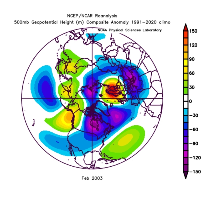
The primary differences between the current d15 ens means and Feb 2003 are the scandi ridge blocking 50/50s from running away and the SW conus had an open door for shortwaves. No guidance is showing a scandi ridge but we don't need that anyways. Just a modest-ao or nao can do the same thing. Plenty of hints that may happen. While the pattern as shown could start out dry, I don't think that will last.
My guess is the first carve end of month hits us flush with cooler air but the trough will carve/broaden in succession as the +PNA shifts and backs off. Just a guess. We'll see

-
12
-
-
18 minutes ago, Ji said:
EPS has us back in colder pattern by the end of the month but it dosent look especially wet initially
.png.256439071903470ed32dba953bb02f2a.png)
Looks like a weak clipper and/or collision pattern for us. The linked pna/epo ridge will shut off the northern stream. They'll still exist but NS shortwaves will originate over the ice cap lol. I don't think it will be a dry pattern in the deep south/east coast. Split flow off the CA coast will let stuff undercut the ridges in the west. No real blocking so storm track can end up anywhere but with cold air cycling down on a SE trajectory over the lakes, an undercutter can easily collide with this. Best analog I can think of is Feb 2003 lol
-
17
-
-
50 minutes ago, Ji said:
is there a slight can kick of when the pattern changes back? @Bob Chillalways say add a week to it--so that would take us to Feb 6 instead of January 30th....EPS still have above normal temps late Jan even though the pattern is clearly changing
From what I see, temps will keep us shut out for about a week. Then back to favorable temps by Feb 1st. Maybe a day or 2 before. But that's just temps. How quick something breaks right is just wild guessing for now. If we're on a true back half heater, we may not have to wait long.
-
9
-
-
@Ji JMA joined the party. Looks just like the euro at H5. Every global agrees on a favorable pass now.
-
21
-
1
-
-
Just now, EB89 said:
What’s the potential start time looking like at DCA?
Pre-dawn Friday as it stands now.
-
4
-
1
-
-
5 minutes ago, stormtracker said:
Man, I haven't see this bullish Bob Chill in a while. The Anti-Chuck. Love it.
A lot going for this to max out here. Euro has a weak surface low centered in SWVA. Causes surface and mid level winds to veer NE when it matters. This is near perfect for us. If slp were to be stronger and take the same track, 3-6" would come easy imho
-
7
-
3
-
-
WWA for the corridor is a lock imho. Models are dialed in. WSW has entered the chat after the euro run. That was a nice vort pass combined with a real nice column. We're on a heater
-
24
-
-
1 minute ago, stormtracker said:
Wide spread 2-4, entire subforum
If you don't start a thread I will
-
6
-
6
-
-
1 minute ago, stormtracker said:
It's a good run still. Vort pass is under us ( @Bob Chill ) confirm
Incremental step towards max potential imo. These NS deals are tricky with qpf leading in. Based on h5/h85 it looked good for us.
-
7
-
-
22 minutes ago, stormtracker said:
I got the Bob Chill endorsement for a thread now. I'm scared
We're 72 hours out and all reliable and unreliable models show some amount of snowfall. Maybe the storm will feel underappreciated and move to SNE because you DIDN'T start a thread
-
3
-
13
-
-
1 minute ago, stormtracker said:
So tempted to do a voodoo magic thread. Imma wait, calm down.
Just do it. It's unlikely to evaporate. Nobody is expecting a big hit except Ji. We can prob be civil running up to 3" and back to 1" every 6 hours lol
-
8
-
2
-
-
Nice column for Friday. No worries with SW mid-level flow as the (weak) low approaches. WAA snow along warm fronts with NS shortwaves is typically low ratio. Kinda globular lol. Maybe not this time. 10:1+ seems likely to me.
-
11
-

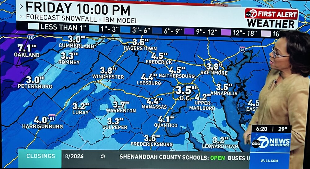
Jan 19th Storm OBS Thread
in Mid Atlantic
Posted
March 2015 had 2 events in one week pop up out of nowhere lol. Small but still. It was a wild month front to back