

Picard
-
Posts
499 -
Joined
-
Last visited
About Picard

Recent Profile Visitors
2,984 profile views


-
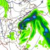
What model do you think performed best? It looked to me like the NAM picked up on the sharp cutoffs to the west and the 10" I have here are maybe a bit over what it's last couple of runs showed for western NJ, but definitely within the range.
-
Try resizing them on your phone before uploading. Android makes it pretty simple to do, and you can usually get them under 1 MB.
-
Measured 9 3/4" at 7:45 AM, but it's a little hard to measure. I had 4 3/4" at about 10:00 pm last night, so only received about 5" overnight. Currently lighter snow and 27. Congrats to the folks out east and down the shore!
-
2 3/4" new accumulation. 1" per hour rates.
-
there is reason to be a bit skeptical of the big totals west of 287. Especially because a couple models seem to have ticked east with the heaviest earlier today, and unless we get big time banding out here, 20+ is just a dream. I'm still thinking high single digit/low double digit totals are within reach.
-
Light to Moderate snows in Sparta, starting to stick everywhere.
-
Western parts of the area aren't far from of a 4-6 inch snowstorm if she were to wobble a bit further east, so it's really a nowcasting, watch the radar time. I am confident some areas will get 18+ and really jackpot, and it will be interesting to overlay actuals with the models when all is said and done.
-
Watching the models, +/- 30 miles will make a big difference up here between less than 6" or more than 12". Personally, I'm routing for 6-12" and watching the costal areas get dumped on. I'm actually OK with not getting 18-20" up this way, but we'll see. Not looking to jinx anything, just giving my personal take.
-
School has called a delay for tomorrow morning due to forecasted ice. Where is the precip coming from? It's mostly dissapating as it heads east.
-
0.6"
-
If the moisture column saturates in time to reach the ground before it's halfway over, and IF rates get heavy enough. Two big IFs, especially northern areas.
-
Doesn't look like much of anything coming north of 195, or is that because the radar is down?
-
The D2 drought category had been removed from northern NJ and eastern PA after the storm 2 1/2 weeks ago, only to be added right back with this update. Dryness continues.
-
Flurries have developed here.
-
Looks like we are going to stay socked into the clouds today up this way.

