
EstorilM
-
Posts
123 -
Joined
-
Last visited
Content Type
Profiles
Blogs
Forums
American Weather
Media Demo
Store
Gallery
Everything posted by EstorilM
-
Your daily rain record for 5yr is an inch? What about the summer storms that dump like 2+” and such??
-
PWS’s say 1.35” south of Leesburg, 1.25” near Middleburg. Didn’t most high-res models show 2-2.25? Don’t get me wrong, the rain is great - but it the models are (once again) off by this much, winter is going to be a huge PITA lol. It was about .90” till that last storm-wide band (NW to SE) came through a little while ago.
-
Due for it?! I got down to -2.4 degrees last year in Northern VA! We had some brutally cold stretches last year (with absolutely ZERO precip.) Actually, wasn't that most of last winter? lol
-
Hit 32.0 exactly this morning for the first time... today has this raw winter post-FROPA kinda look to it, with gusty winds and the lower sun angle (and shorter days) casting plenty of cloud shadows and making them seem darker in the process. Definitely one of those afternoons where you can tell it'll be cold tonight! Freeze warning for all of Loudoun.. I'm usually about 3-5 degrees cooler than forecast so we'll see.
-
Agreed - hardly any discussion about it. I guess we got burned on the last one though.
-
.12" near Leesburg per my PWS - shafted as usual. Was hoping for at least .25"
-
Still got your hopes up for a second, so it served its purpose. The weather Gods will allow our weekend activities to remain, as long as this shockingly boring and dry pattern continues (save for this trough / cold front thing tomorrow night / wed AM.)
-
I came in here just to ask this! It filled in like some late evening fog / humidity will sometimes (usually in clear air mode) but it’s in precipitation mode. It’s accurately showing the rain to the NW… nothing wrong with the radar it would seem, unless the software isn’t filtering out stuff like it usually does. There is motion / waves to it that reflects what moisture in the atmosphere would be doing - just not sure why it’s only visible around IAD / the radar. edit: They just now put it into clear air mode. My bet is they’re troubleshooting the filtering.
-
Yeah, what's the deal with that anyways? Getting kinda nervous about my camping trip already. I actually wanted a day or two of rain (it's kinda relaxing) but if it all turns to mud, I'm OUT lol.
-
Something must have changed with the 06Z runs or something. I'm going off-roading / camping in the George Washington National Forest starting on the 13th, and all of a sudden they're saying rain Friday, Saturday, Sunday, and Monday (12-15th!) I know that's still too far out to know, but for four days of rain, it has to be a larger system. I haven't had time to look at any models yet, but last night before I went to sleep, I think it had a chance of rain for Wednesday that week, but that was it. It really CAN'T be that weekend/early week because I'll still be on the trails and won't have the camp site set up yet. Saturday especially was just going to be a trail day - if it's raining Friday and Saturday that would be a bad idea with the mud and creek crossings.
-
We paid for it with that insane heat wave during most of June! I like the temperatures and all, but having a peak of like 5% chance of rain for the next week is a serious snooze fest. I'm going camping mid-September and it would be nice to have some variable weather, or maybe a thunderstorm once or twice, etc. I know it's a ways out, but that's starting to feel very unlikely lol.
-
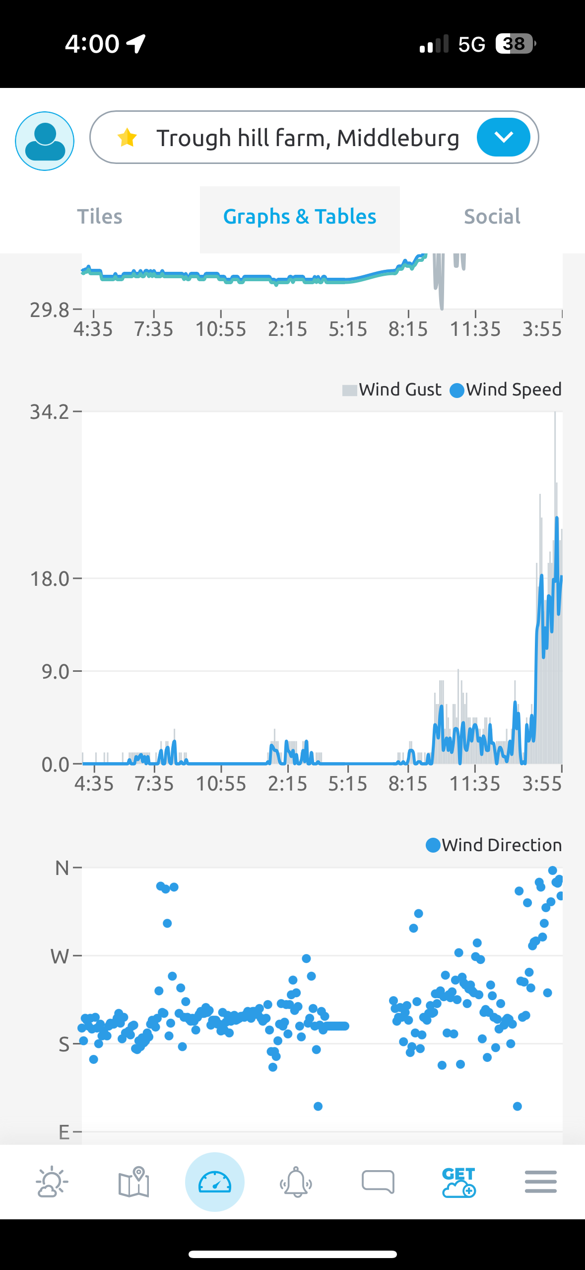
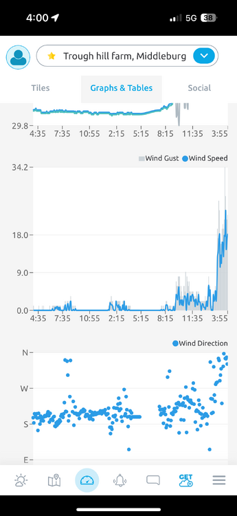
Just randomly gust to 35 after being basically dead calm all day. I knew the front was coming through but this is powerful - must have caught LWX off guard too, no mention of headlines in any recent disco and they issued the advisory after the winds hit.
-
Peak gust 34.2 a little bit ago - it was dead calm here at the farm, then BOOM. We have a clear shot of flat fields towards the valley at the base of the blue ridge, so it hits pretty quick and doesn’t let up. I’m a little surprised about the wind advisory being issued as the event is already taking place - kinda sounds like they got caught with their pants down on this one.
-
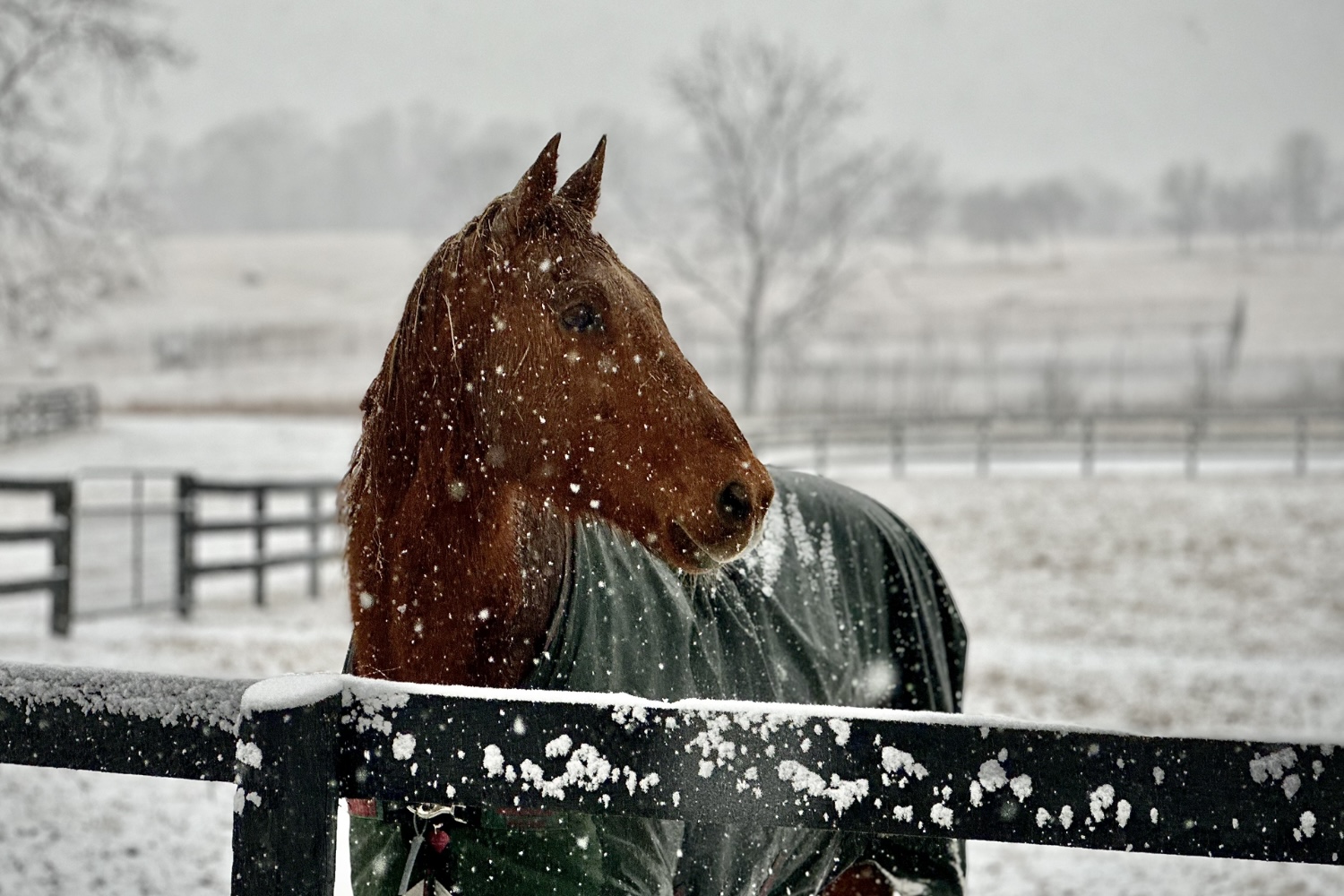
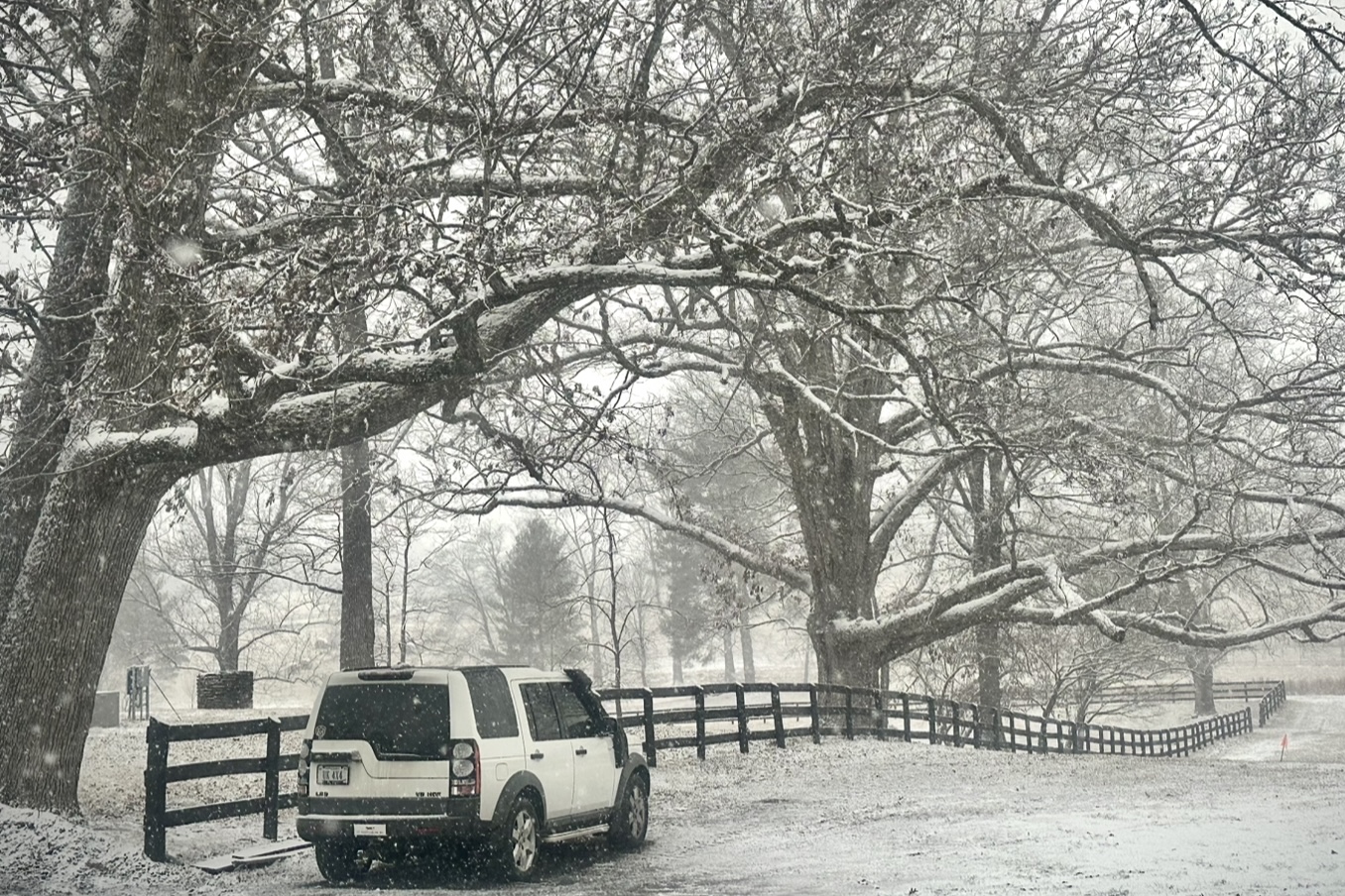
Back roads now covered (went from nothing to a coating in the last 15 minutes). The horses aren’t thrilled but the dogs definitely are lol.
-
Hey, you’re back!
-
Grass is pretty much covered now, really accumulating now with the lowering sun angle.

-
WTOP radio just said “looks like the DC area is going to be the jackpot for this winter storm”
-
Just transitioned to legit snow in Middleburg now, vis dropping, car said temps down to 29 degrees a minute ago to grab some lunch.
-
Temps down 5 degrees in 1.5hr down to 30.7 - nothing accumulating yet but this has some thump potential if the show isn’t supposed to start for another ~4hr or so.
-
Damn, weather radio just set off in the tractor - I didn’t realize the mountains were in an ice storm warning for up to 1/3” of ice (AFTER the WSW stuff). That’s no joke…
-
Mike Thomas’ adjustments last night (narrowing the jackpot zone) look pretty good, I think he had 5-8” for a narrow swath. I don’t hear him mentioned much, but he’s a pretty good local met for Fox 5 and posts a LOT of stuff on X (especially before/during events.) @MikeTFox5
-
Yup same, every few minutes the flakes get big (only for a second or two) then back to flurries, kinda interesting. Moving some hay around for horses with the tractor and it’s almost windshield wiper time. Ok, more like windshield “wipe” time. Actually as I’m typing the flurries just filled in a bunch, don’t have to look for it now - borderline snow. edit: Just checked RadarScope and STATE COLLEGE 110mi north has snow reports also? That’s crazy they filled in the same time as DC suburbs and it’s been snowing since sunrise in RIC lol.
-
I feel like most of this is going to fall well after most are already home from school though? (Like on a normal day) - weird. I’d totally understand canceling afterschool activities though.
-
Did anyone actually have an early dismissal today? I can kinda understand a delay tomorrow.
-
Temps dropped 1.5 degrees in about 25 min, south winds up a bit too (7g15) - sideways flurries filling in a bit.