
EstorilM
-
Posts
101 -
Joined
-
Last visited
About EstorilM

- Birthday 06/11/1984
Recent Profile Visitors


-
We already took the medals from them, can we just kinda... take their cold air as well? I guess the time to ask would have been yesterday lol.
-

Feb 22nd/23rd "There's no way..." Obs Thread
EstorilM replied to Maestrobjwa's topic in Mid Atlantic
I guess it depends when they measured, I work within walking distance to Sterling NWS/LWX and passed it this morning at 7am - I'd say closer to 1-1.5" but I guess that's kinda splitting hairs. -
Feb 22nd/23rd "There's no way..." Obs Thread
EstorilM replied to Maestrobjwa's topic in Mid Atlantic
Yup, I definitely said "no way" on what, Friday? Not a chance it meets criteria - advisory seemed appropriate factoring in temps. I mean the MODELS showed 5-8" of snow possibly falling out of the sky, but we've been through this a million times. The only element of this storm that surprised me (for my area) was just how many of the mets seemed to buy into the model hype without taking a step back for a moment. Then again, you get into even a 2 degree difference and I guess it's a slightly different story, but ground temps were warm too - AND that band never really set up through northern-western Loudoun regardless, so I don't think we even had the QPF there after the 3-4pm (brief) thump; that was the end of the real event for me (which was not how it was supposed to play out, nor what the WSW had either.) -
Feb 22nd/23rd "There's no way..." Obs Thread
EstorilM replied to Maestrobjwa's topic in Mid Atlantic
Got an inch south of Leesburg - marginal temps in a storm like this will always disappoint. I'm kinda impressed LWX bit onto the models too and had like 5-8 here lol. -
Feb 22nd/23rd "There's no way..." Obs Thread
EstorilM replied to Maestrobjwa's topic in Mid Atlantic
Hmm, got down to about 35 an hour ago, now up to 36.9! -
Feb 22nd/23rd "There's no way..." Obs Thread
EstorilM replied to Maestrobjwa's topic in Mid Atlantic
Down to 35.4, first wet flakes of the event just started mixing in (south of Leesburg.) -
Feb 22nd/23rd "There's no way..." Obs Thread
EstorilM replied to Maestrobjwa's topic in Mid Atlantic
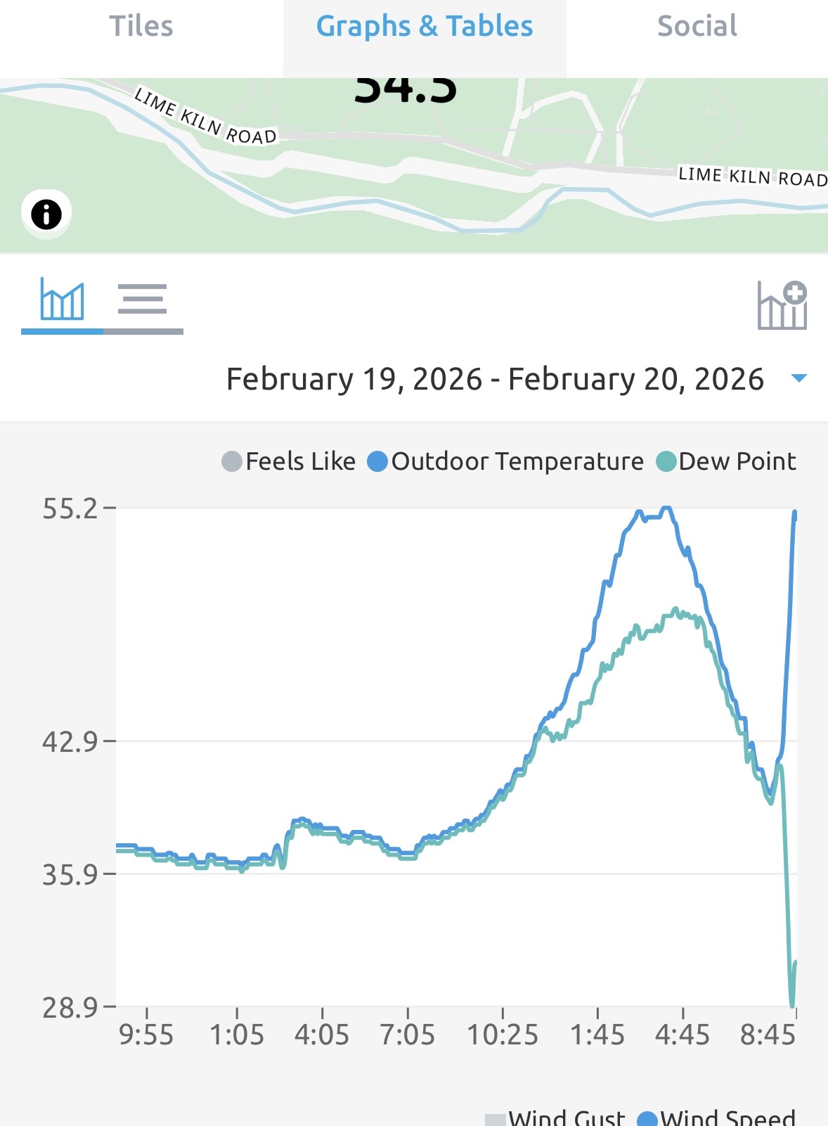
And the wait begins… look at the bright side, we don’t have to worry about virga!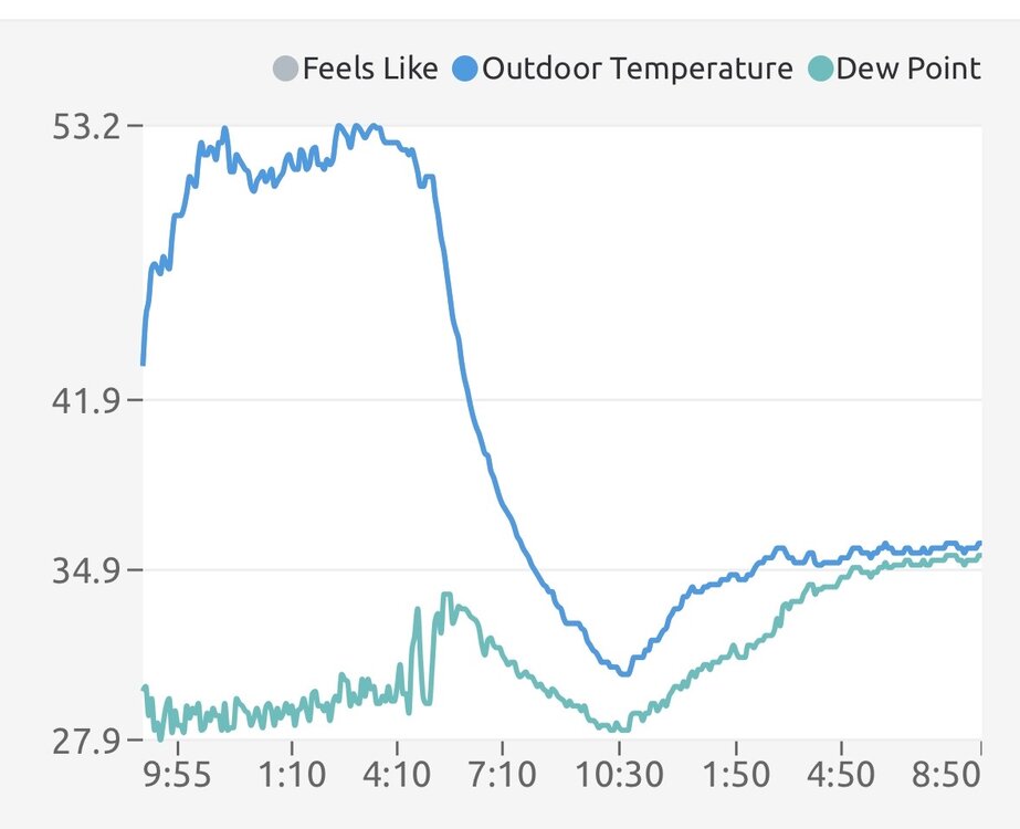
-
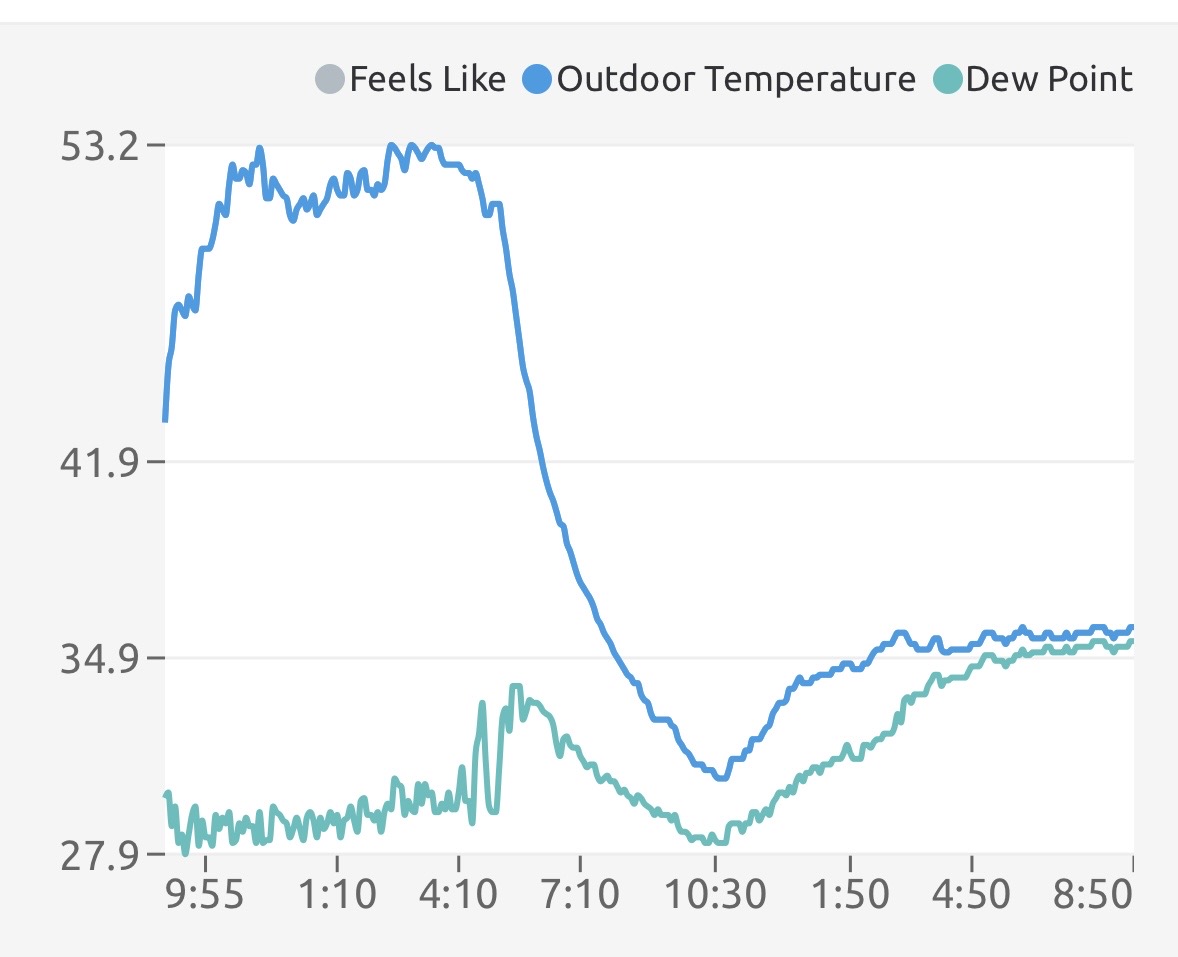
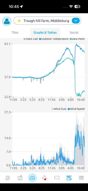
Yup I’m near the Blue Ridge mtns in Middleburg, not sure that’s close enough to have that impact though. The winds definitely jumped with the temp and dew point change, but the direction didn’t much (possible SW to WNW.) 14 deg temp change, 25 deg dew point change!
-
I just had the most bizarre thing happen. Glanced at my weather station and it said 55 degrees - I SWORE it showed 40 the last time I looked (when I got home around 730pm.) So I checked and sure enough, rose 15 degrees in less than an hour, after dark! I have another station at the farm a few miles away and it also showed a 15 degree jump.

-
Feb 22nd/23rd "There's no way..." Storm Thread
EstorilM replied to Maestrobjwa's topic in Mid Atlantic
Makes me miss Snobol lol -
Feb 22nd/23rd "There's no way..." Storm Thread
EstorilM replied to Maestrobjwa's topic in Mid Atlantic
Haha I just clicked refresh on that as well and saw it was "updated" but it doesn't seem like they even touched the stuff regarding the storm potential. -
Feb 22nd/23rd "There's no way..." Storm Thread
EstorilM replied to Maestrobjwa's topic in Mid Atlantic
Nah IMO with the temp profiles and this thing looking very coastal (I don't think we get the tilt early enough to bring it too far west of I-95) I think this is more of an advisory event for us unfortunately. Criteria for LWX is 5" - then again a watch means it only needs to be "possible" so... -
Feb 22nd/23rd "There's no way..." Storm Thread
EstorilM replied to Maestrobjwa's topic in Mid Atlantic
Based on their latest disco, I think they'll wait till the very last second for this one. Way too many stars need to align for this thing to be "dangerous" IMO. Sterling / LWX quote snippet sums up this whole mess perfectly: -
Feb 22nd/23rd "There's no way..." Storm Thread
EstorilM replied to Maestrobjwa's topic in Mid Atlantic
This has been my thought all along, which is why I haven't even looked at this thread till right now. We need the phase, the block, the trough to go negative, blah blah - even then temps are going to be close. I'm not being a "downer" but statistically the odds of everything coming to fruition are almost zero, and we literally need every element for this to be snow - otherwise it's (beneficial) rain, and / or wet snow melting on contact. I'm trying to stay grounded here; I've been blown up on social media for the last 24hr about a 3' monster snowstorm because of what the GFS showed lol. -
Nice - I was waiting for the update, they seemed all-in on the previous AFD as well (unusual for them.)